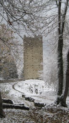
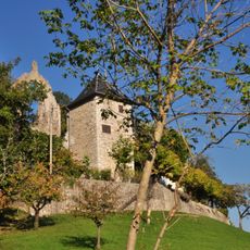
Château de Montmayeur, Medieval castle ruins in Villard-Sallet, France.
Château de Montmayeur is a castle ruin located at 800 meters elevation on the Montraillant ridge, controlling routes between Chambéry and Italy through the Maurienne valley. The site has a rectangular layout spanning roughly 250 meters with two surviving towers from the late medieval period.
The castle was first documented in 1173 and served as a strategic outpost for the Counts of Savoy. It became the seat of the Montmayeur family until the 15th century, when its importance as a stronghold gradually declined.
The rectangular enclosure contains two preserved towers from the late 14th century, showing how medieval military structures were built in the Savoy region. Walking through the ruins reveals the layout and design choices that made these fortifications effective for defense.
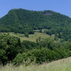
The ruin sits on a mountain ridge at elevation and requires a significant climb to visit. The best times to explore are during good weather when visibility across the surrounding mountains is clearest.
Archaeological excavations from 1992 to 1998 directed by Jean-Michel Poisson revealed substantial information about the castle's construction and its inhabitants across the centuries. These excavations uncovered details about how medieval occupants adapted and modified the structure over time.
Location: Villard-Sallet
GPS coordinates: 45.48990,6.12381
Latest update: December 9, 2025 20:20
Château de la Rochette
3.5 km
Abbaye du Betton
4.9 km
Pont Victor-Emmanuel
3.8 km
Pont Morens
5 km
Maison forte du Chanay
5.1 km
Pic de l'Huile
3.7 km
Val Coisin
1.7 km
Hôtel Nicolle de La Place
5.2 km
Église Saint-Jean-Baptiste de Saint-Jean-Pied-Gauthier
2 km
Église Saint-Jean-Baptiste de La Rochette
3.6 km
Église Saint-Pierre et Saint-Paul
4.3 km
Église Saint-Laurent d'Étable
3.3 km
Église Saint-Nicolas d'Arbin
4.9 km
Église de la Sainte-Vierge de Rotherens
2.1 km
Église Saint-Laurent de Cruet
4.7 km
Église de l'Assomption-de-Notre-Dame de Montmélian
5.1 km
Église Saint-Martin de Villard-d'Héry
2.9 km
Église de Saint-Pierre-de-Soucy
1.4 km
Église Notre-Dame-de-l'Assomption
3.9 km
Église Saint-Pierre de Coise
4.1 km
Église Sainte-Hélène de Sainte-Hélène-du-Lac
4.7 km
Église Saint-Michel de La Croix-de-la-Rochette
2.3 km
Église Saint-Michel de La Chavanne
4 km
Église Saint-Sixte de Planaise
3.1 km
Église Saint-Pierre de Villaroux
5.3 km
Pont Morens
5 km
War memorial of Montmélian
5.2 km
Chapelle Saint-Sébastien du Mont-Cenis
5.1 kmVisited this place? Tap the stars to rate it and share your experience / photos with the community! Try now! You can cancel it anytime.
Discover hidden gems everywhere you go!
From secret cafés to breathtaking viewpoints, skip the crowded tourist spots and find places that match your style. Our app makes it easy with voice search, smart filtering, route optimization, and insider tips from travelers worldwide. Download now for the complete mobile experience.
A unique approach to discovering new places❞
— Le Figaro
All the places worth exploring❞
— France Info
A tailor-made excursion in just a few clicks❞
— 20 Minutes