Ramparts of Saint-Malo

Log in to your account

AroundUs is a community-driven map of interesting places, built by curious explorers like you. It grows with every review, story, and photo you share.
Connect to save your favorite spots, contribute locations, and create personalized routes.
By continuing, you accept our Terms and Conditions and our Privacy Policy
Add to collection
Map
Suggest a change
Share

Ramparts of Saint-Malo, Medieval fortification system in Saint-Malo, France

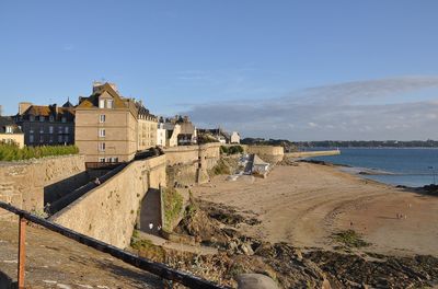
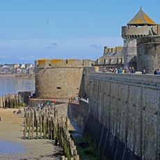
The Ramparts of Saint-Malo are granite walls stretching two kilometers around the old town, with eight gates, three secondary entrances, and several bastions forming a complete defensive ring. The structure encloses the historic center and allows visitors walking the top to view both the buildings inside and the bay and islands outside.

Construction began in the 12th century and the walls were rebuilt and reinforced after a major fire in 1661. The architect Garangeau shaped their current form through modifications in the 18th century.

The walls form a continuous path where locals walk daily and visitors sense the rhythm of a city built for defense and trade. This space shows how the fortifications shaped daily life and remain central to how people experience Saint-Malo.

Walking the entire circuit takes around one hour and staircases at each gate provide access to the top. The path is exposed to weather and can be slippery when wet, so sturdy shoes and caution are advisable.

The Bidouane Tower has an unusual horseshoe shape and once stored gunpowder and explosives during conflicts. From this point, visitors can see across the bay toward the islands and understand how the fort controlled the harbor.

Location: Saint-Malo

Address: place Chateaubriand

GPS coordinates: 48.65140,-2.02280

Latest update: December 6, 2025 16:03

Photos
Saint-Malo: sandy beaches, stone walls, coast paths

Saint-Malo is a seaside town where stone is everywhere. Strong city walls surround the old part. Gray granite streets lead down to the harbor. Sand beaches stretch along the walls. Walking on the walls, you see the bay and islands on the horizon. Fort National sits on its island, reachable at low tide, and Sillon beach offers a direct view of the sea from the town center. The Solidor tower and old gates like Porte Saint-Vincent remind us of the port’s long history. The photos show places that link the town to the sea. You can see beaches like Éventail, Bon-Secours, and La Hoguette, each with its own feel. The 12th-century walls are good for walking because they always give a view of the water. Parks like Jardin des Douves and the village of Aleth show how nature and history live side by side here. Even Rue du Jerzual in Dinan, outside Saint-Malo, shows old crafts and houses built into the hills.

Reviews

Real people, real opinions — but not verified.

Visited this place? Tap the stars to rate it and share your experience / photos with the community! Try now! You can cancel it anytime.

stephren
@stephren

Mar 31, 2025 15:00

A very nice walk on the ramparts!

« Ramparts of Saint-Malo - Medieval fortification system in Saint-Malo, France » is provided by Around Us (aroundus.com). Images and texts are derived from Wikimedia project under a Creative Commons license. You are allowed to copy, distribute, and modify copies of this page, under the conditions set by the license, as long as this note is clearly visible.

Discover hidden gems everywhere you go!

From secret cafés to breathtaking viewpoints, skip the crowded tourist spots and find places that match your style. Our app makes it easy with voice search, smart filtering, route optimization, and insider tips from travelers worldwide. Download now for the complete mobile experience.

Around Us App Screenshot

A unique approach to discovering new places

Le Figaro

All the places worth exploring

France Info

A tailor-made excursion in just a few clicks

20 Minutes