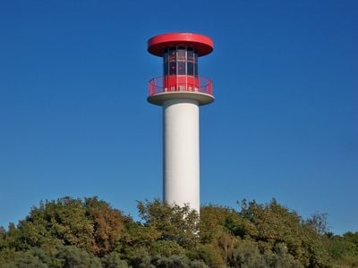
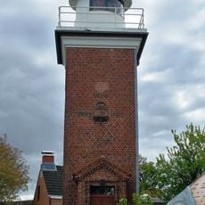
Heiligenhafen warning light, Concrete lighthouse in Schleswig-Holstein, Germany.
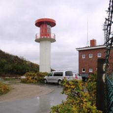
The Heiligenhafen warning light is a concrete tower reaching 20 meters tall with its light positioned 27 meters above the Baltic Sea surface. This utilitarian structure stands at the harbour entrance and continuously transmits navigation signals to passing vessels.
An earlier light mounted on a fish packing facility burned down in 1907, leading to the construction of this concrete tower in 1938. The present structure has served without major alteration since its completion in the late 1930s.
This navigation tower has guided mariners into Heiligenhafen harbour for nearly a century and remains a reference point embedded in the daily awareness of local seafarers. Fishermen and captains depend on its position as part of the area's maritime culture.
The tower stands directly at Heiligenhafen's harbour edge and is easily visible from the water and dock areas. You can view the structure from the outside, but access inside is restricted to authorized personnel only.
The tower broadcasts yellow and red flashing lights that pulse every 5 seconds, creating a distinctive visual code for maritime traffic. This two-colour signalling pattern sets it apart from other navigational lights along the coast.
The community of curious travelers
AroundUs brings together thousands of curated places, local tips, and hidden gems, enriched daily by 60,000 contributors worldwide.