Lac de la Landie

Log in to your account

AroundUs is a community-driven map of interesting places, built by curious explorers like you. It grows with every review, story, and photo you share.
Connect to save your favorite spots, contribute locations, and create personalized routes.
By continuing, you accept our Terms and Conditions and our Privacy Policy

Lac de la Landie

Add to collection
Map
Suggest a change
Share

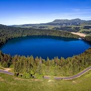
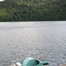
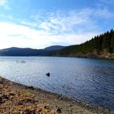
Lac de la Landie, lake in Égliseneuve-d'Entraigues, France

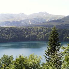
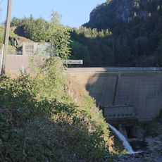
Lac de la Landie is a lake in Égliseneuve-d'Entraigues on the southern slopes of the Sancy massif, about three thousand three hundred feet (a thousand meters) above sea level and covering roughly 72 acres (29 hectares). The water is clear and cold even in summer, resting on a bed of basaltic rock with depths reaching about 66 feet (20 meters) in places.

The lake formed during the ice age when glaciers carved a large basin into the volcanic rock that later filled with water. From 2003 to 2016 the site was known as a fly fishing destination and remains an annual training ground for the French national team.

Access to the shore is free even though the lake is privately owned and swimming or fishing without permission is not allowed. A small stream flows through the lake and a peat bog area at the inlet offers a view of the wetland plants of the region.

The French national fly fishing team still trains here once a year, showing that the trout are particularly easy to observe and catch. The clarity of the water makes it possible to watch fish swim near the surface or along the bottom.

Location: Égliseneuve-d'Entraigues

Address: Lac de la Landie, 63850 Égliseneuve-d'Entraigues, France

GPS coordinates: 45.42194,2.76694

Latest update: December 4, 2025 11:22

Lakes of Auvergne-Rhône-Alpes: volcanic craters, glacier waters, mountain dams

The Auvergne-Rhône-Alpes area has lakes from very different beginnings. Large lakes that formed from glaciers, like Lake Bourget or Lake Annecy, appeared after the glaciers in the Alps melted. They have deep water surrounded by mountains. In the Massif Central, volcanic lakes sit in old craters, such as Lake Pavin, which is nearly 7,000 years old, and Lake Issarlès, which goes down more than 100 meters deep. Some lakes are high up in the mountains, like Lake Guéry at 1250 meters, while others are in flat land or in deep valleys. There are also several artificial lakes built in the 20th century to make electricity or manage water flow. Lake Monteynard was created in 1962 on the Drac river, and Lake Saint-Étienne-Cantalès, held back by a dam on the Cère river since 1945, are popular spots for swimming, sailing, and fishing. Each lake feels different: clear and cold mountain waters, wooded shores in Jura, changing colors in volcanic craters. Visitors can walk around these places, go by boat, or just enjoy the views from the banks.

Reviews

Visited this place? Tap the stars to rate it and share your experience / photos with the community! Try now! You can cancel it anytime.

« Lac de la Landie - lake in Égliseneuve-d'Entraigues, France » is provided by Around Us (aroundus.com). Images and texts are derived from Wikimedia project under a Creative Commons license. You are allowed to copy, distribute, and modify copies of this page, under the conditions set by the license, as long as this note is clearly visible.

Discover hidden gems everywhere you go!

From secret cafés to breathtaking viewpoints, skip the crowded tourist spots and find places that match your style. Our app makes it easy with voice search, smart filtering, route optimization, and insider tips from travelers worldwide. Download now for the complete mobile experience.

Around Us App Screenshot

A unique approach to discovering new places

Le Figaro

All the places worth exploring

France Info

A tailor-made excursion in just a few clicks

20 Minutes