·

Enable Location

We need your location to show you interesting places around you

Discover nearby places

Find interesting locations and hidden gems around you

Precise directions

Get accurate directions and distances to places

Your location is never shared with other users. It's only used when you tap the location button.

Celleno

Log in to your account

Start exploring — it's free

Trusted by 62,667 travelers worldwide

Continue with Google
Continue with Apple
or

We will send you a code to connect

By continuing, you accept our Terms and Conditions and our Privacy Policy

Check your inbox

We've sent a pincode in your inbox. Please enter the code below.

Celleno, Italian comune

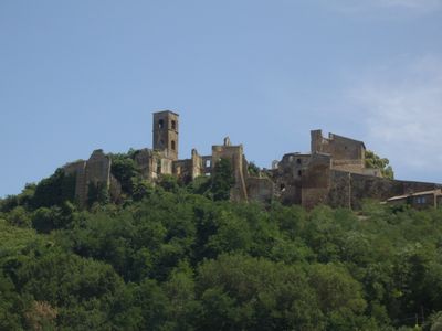
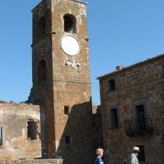
Celleno is an abandoned commune in the province of Viterbo built on a soft tufa stone hillside about 350 meters (1,150 feet) above sea level. The village consists of narrow streets, simple stone houses, the Castello Orsini surrounded by a moat, a church from around the year 1000, and remains of several smaller churches, while erosion of the hillside threatens the stability of the older buildings.

Etruscan settlement dates to the seventh century BC, though exact founding details remain unclear. Later the location became a strategic point under Roman control between Orvieto and nearby centers, until landslides and earthquakes in recent centuries caused the village to be abandoned.

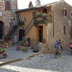
The name may derive from Etruscan origins or from underground caves carved into the rock. Today, visitors can walk through narrow streets and see simple stone houses that reveal how people once organized their daily lives in this hillside settlement.

The place is best reached by car from Viterbo using the provincial road S.P. 5 and following signs to the village. It is wise to check with the local town hall before visiting, as accessibility can vary depending on weather and damage, and not all areas may be open to the public.

Archaeological excavations uncovered a rare object called a glirarium, an ancient container used to keep small animals possibly for food or care, offering insight into daily life of ancient residents. Additionally, there are underground caves carved into the rock where ancient people stored wine and worked with tools.

The community of curious travelers

AroundUs brings together thousands of curated places, local tips, and hidden gems, enriched daily by 60,000 contributors worldwide.

Start exploring
Capital city
Celleno
Elevation above the sea
407 m
Shares border with
Bagnoregio, Viterbo
GPS coordinates
42.56083,12.13722
Latest update
February 7, 2026 09:31
« Celleno - Italian comune » is provided by Around Us (aroundus.com). Images and texts are derived from Wikimedia project under a Creative Commons license. You are allowed to copy, distribute, and modify copies of this page, under the conditions set by the license, as long as this note is clearly visible.

Discover hidden gems everywhere you go!

From secret cafés to breathtaking viewpoints, skip the crowded tourist spots and find places that match your style. Our app makes it easy with voice search, smart filtering, route optimization, and insider tips from travelers worldwide. Download now for the complete mobile experience.

Around Us App Screenshot

A unique approach to discovering new places

Le Figaro

All the places worth exploring

France Info

A tailor-made excursion in just a few clicks

20 Minutes

Around Us
Travel Guide & Maps
Download

Send to your phone

QR Code
1

Open the camera app on your mobile.

2

Point at the QR code with your camera. A notification will appear.

3

Tap the notification to open the link.