Enable Location

We need your location to show you interesting places around you

Discover nearby places

Find interesting locations and hidden gems around you

Precise directions

Get accurate directions and distances to places

Your location is never shared with other users. It's only used when you tap the location button.

Yoroi-jinja

Log in to your account

Start exploring — it's free

Trusted by 62,597 travelers worldwide

Continue with Google
Continue with Apple
or

We will send you a code to connect

By continuing, you accept our Terms and Conditions and our Privacy Policy

Check your inbox

We've sent a pincode in your inbox. Please enter the code below.

Yoroi-jinja

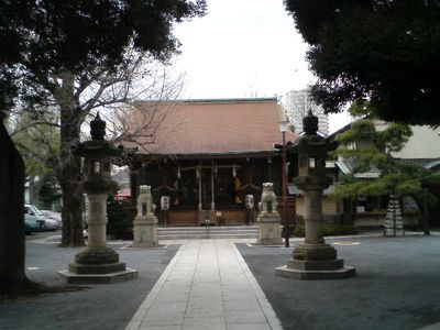
Yoroi-jinja, Shinto shrine in Japan

Yoroi-jinja is a small Shinto shrine in Shinjuku with a simple wooden structure and traditional roof. The well-kept grounds contain stone lanterns, small statues, and several subsidiary shrines, including Tenjin-sha dedicated to the god of learning.

This shrine was founded over a thousand years ago during Emperor Daigo's reign when the monk Jōsū built it to protect the nearby Enshō-ji Temple. Its history is linked to the warrior Taira no Masakado, whose armor is said by legend to be buried here.

The name Yoroi refers to armor and connects this place to legends of the samurai Taira no Masakado. Visitors come here to offer prayers for protection and to pay respect, showing how local traditions and ancient warrior stories remain alive in daily life today.

The shrine is easily accessible on foot from nearby train stations and sits in a lively area with shops close by. The compact grounds are easy to navigate, allowing for a quick visit, especially on weekdays when it is quieter.

An old tree called the Helmet Tree marks the spot where the helmet of Taira no Masakado is said by legend to be buried. After World War II, this warrior's spirit was moved back to the main hall at the request of local residents.

The community of curious travelers

AroundUs brings together thousands of curated places, local tips, and hidden gems, enriched daily by 60,000 contributors worldwide.

Start exploring
Location
Address
東京都新宿区北新宿3-16-18
GPS coordinates
35.70449,139.69171
Latest update
February 9, 2026 08:23
Around this place
Guam National Wildlife Refuge
United States of America

Guam National Wildlife Refuge

2509 km
Chugai' Pictograph Site
United States of America

Chugai' Pictograph Site

2462.9 km
Ypao Beach
United States of America

Ypao Beach

2523.5 km
Asan Invasion Beach
United States of America

Asan Invasion Beach

2525.3 km
Nanyo Kohatsu Kabushiki Kaisha Sugar Mill
United States of America

Nanyo Kohatsu Kabushiki Kaisha Sugar Mill

2461.8 km
Catholic Belltower
United States of America

Catholic Belltower

2359.9 km
Laulau Kattan Latte Site
United States of America

Laulau Kattan Latte Site

2459.2 km
South Finegayan Latte Stone Park
United States of America

South Finegayan Latte Stone Park

2518.9 km
Naton Beach
United States of America

Naton Beach

2522.8 km
Dungcas Beach Defense Guns
United States of America

Dungcas Beach Defense Guns

2524.7 km
Gongna Beach defenses
United States of America

Gongna Beach defenses

2521.5 km
Santa Remedios Church
United States of America

Santa Remedios Church

2356.5 km
Ipao Pillbox I
United States of America

Ipao Pillbox I

2523.2 km
Tarague Beach
United States of America

Tarague Beach

2512.5 km
Pau Pau Beach
United States of America

Pau Pau Beach

2356 km
NCS Beach
United States of America

NCS Beach

2519.6 km
Family Beach
United States of America

Family Beach

2525.1 km
Micro Beach
United States of America

Micro Beach

2358.1 km
Ritidian Beach
United States of America

Ritidian Beach

2508.6 km
Gabgab Beach
United States of America

Gabgab Beach

2527.4 km
Korean Air Flight KE801 1997-Crash Memorial
United States of America

Korean Air Flight KE801 1997-Crash Memorial

2527.7 km
Outhouse Beach
United States of America

Outhouse Beach

2525.2 km
Trinchera Beach
United States of America

Trinchera Beach

2525.7 km
Haputo Beach
United States of America

Haputo Beach

2516.4 km
Dungcas Beach
United States of America

Dungcas Beach

2524.7 km
Gongna Beach
United States of America

Gongna Beach

2522.2 km
Unai Baput
United States of America

Unai Baput

2365.4 km
Unai Makpe
United States of America

Unai Makpe

2354.3 km
Show the full map
« Yoroi-jinja - Shinto shrine in Japan » is provided by Around Us (aroundus.com). Images and texts are derived from Wikimedia project under a Creative Commons license. You are allowed to copy, distribute, and modify copies of this page, under the conditions set by the license, as long as this note is clearly visible.

Discover hidden gems everywhere you go!

From secret cafés to breathtaking viewpoints, skip the crowded tourist spots and find places that match your style. Our app makes it easy with voice search, smart filtering, route optimization, and insider tips from travelers worldwide. Download now for the complete mobile experience.

Around Us App Screenshot

A unique approach to discovering new places

Le Figaro

All the places worth exploring

France Info

A tailor-made excursion in just a few clicks

20 Minutes

Around Us
Travel Guide & Maps
Download

Send to your phone

QR Code
1

Open the camera app on your mobile.

2

Point at the QR code with your camera. A notification will appear.

3

Tap the notification to open the link.