Statfjord, Oil and gas field in North Sea, Norway and United Kingdom
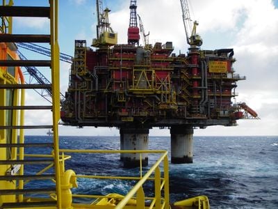
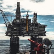
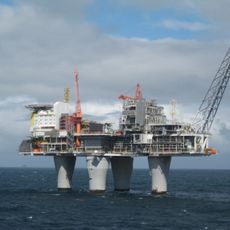
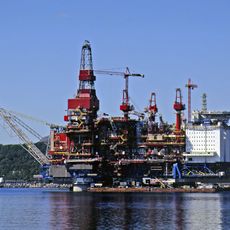
The Statfjord field covers 580 square kilometers along the British-Norwegian border in the North Sea at a water depth of 145 meters.
Mobil discovered Statfjord in 1974, and Statoil, now Equinor, assumed control of operations on January 1, 1987, marking a shift in North Sea petroleum management.
The field development represents a milestone in Norwegian-British cooperation, with Norway holding 85 percent and the United Kingdom 15 percent of ownership rights.
Three concrete production platforms, Statfjord A, B, and C, extract oil and gas from reservoirs located between 2,500 and 3,000 meters beneath the seabed.
On January 16, 1987, Statfjord achieved the highest daily production rate for any European oil field outside Russia, exceeding 700,000 barrels per day.
Inception: 1979
GPS coordinates: 61.25556,1.85389
Latest update: March 4, 2025 04:44
Offshore oil platforms are extraction facilities operating up to 2,450 meters below sea level. From the North Sea to the Sea of Okhotsk, from the Gulf of Mexico to the Brazilian coasts, these structures play a significant role in global energy production. Troll A in Norway rises 472 meters from the seabed, while Berkut in Russia supports 200,000 tonnes of structure weight against Arctic conditions. Each installation adapts to specific constraints based on its location. Hibernia off Newfoundland has withstood iceberg impacts since 1997, whereas Thunder Horse in the Gulf of Mexico produces 250,000 barrels daily at nearly 2000 meters depth. In Brazil, Petrobras' P-51 operates at 1800 meters below water, and the Ekofisk complex in the North Sea comprises 30 interconnected platforms. These examples demonstrate the diversity of technologies used for oil and gas extraction in various marine environments.
Troll A
117.9 km
Brent Spar
25 km
Unst Bus Shelter
155 km
Muckle Flugga Lighthouse
153.4 km
Utvær Lighthouse
144.7 km
Huney
155.1 km
Ytterøyane Lighthouse
154.6 km
Lunde Formation
32.9 km
Bulandet Chapel
148.4 km
Værlandet Chapel
154 km
Olsund Bridge
149.5 km
Utvær
145.4 km
Viking longhouse at Haroldswick
154.1 km
Balta Sound Lighthouse
154 km
Hermaness SSSI
155.6 km
Skaw, radar station
150 km
Unst, Baltasound, Buness House
155.9 km
Haroldswick Methodist Church
152.7 km
Unst Heritage Centre
153.9 km
Lighthouse Shore Station, Burrafirth, Unst
155.1 km
Ordaal, Unst
156 km
Slipway, Lighthouse Shore Station, Burrafirth, Unst
155.1 km
The Skidbladner
154.1 km
Unst, Hagdale, Chromate Quarry, Horse Mill
154.3 km
Skaw Röst
148.4 km
Hermaness National Nature Reserve
155.5 km
Muckle Heog,two chambered cairns,Baltasound
155 km
Gullfax Platform
26.6 kmReviews
Visited this place? Tap the stars to rate it and share your experience / photos with the community! Try now! You can cancel it anytime.
Discover hidden gems everywhere you go!
From secret cafés to breathtaking viewpoints, skip the crowded tourist spots and find places that match your style. Our app makes it easy with voice search, smart filtering, route optimization, and insider tips from travelers worldwide. Download now for the complete mobile experience.
A unique approach to discovering new places❞
— Le Figaro
All the places worth exploring❞
— France Info
A tailor-made excursion in just a few clicks❞
— 20 Minutes