Chest opened
+${chestReward.xp} XP
Explorer
NOUVEAU ×${chestReward.collectible.quantity}
tapez pour fermer
Chest locked

Open chests in the app

Around Us is built for your phone — chests unlock when you walk, explore and capture nearby places.

Enable Location

We need your location to show you interesting places around you

Discover nearby places

Find interesting locations and hidden gems around you

Precise directions

Get accurate directions and distances to places

Your location is never shared with other users. It's only used when you tap the location button.

Tyne and Wear Metro

Log in to your account

Start exploring — it's free

Trusted by 73,016 travelers worldwide

Continue with Google
Continue with Apple
or

We will send you a code to connect

By continuing, you accept our Terms and Conditions and our Privacy Policy

Check your inbox

We've sent a pincode in your inbox. Please enter the code below.

Tyne and Wear Metro
Discussion Reviews 1 Photos
3.7k Popularity

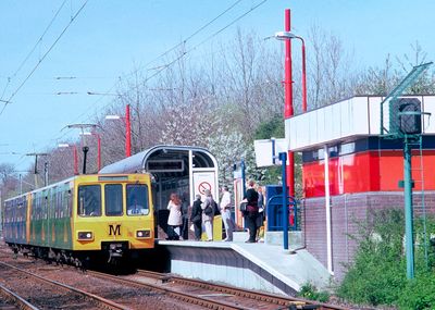
Tyne and Wear Metro, Light rail system in Newcastle upon Tyne, GB

The Tyne and Wear Metro is a light rail network in North East England that links five districts and serves around 60 stations. The line runs partly above ground, partly on raised viaducts, and partly underground, including a stretch beneath central Newcastle.

The Metro opened in January 1980, built partly along old railway corridors that were converted and upgraded for passenger service. The network grew in stages over the following years, with Sunderland joining the line in 2002.

The Metro connects cities like Newcastle, Gateshead and Sunderland with beaches, shopping streets and football grounds, all reachable without a car. On match days, the trains fill with fans travelling alongside everyday commuters, giving the journey a particular energy.

Trains run throughout the day with shorter waiting times during morning and evening rush hours. Stations are clearly signed and the network is straightforward to follow, as there are only a few lines to keep track of.

Newcastle Airport station was one of the first in the UK where a metro line ran directly to a scheduled domestic airport. Passengers can travel from the city centre to the terminal without changing trains.

The community of curious travelers

AroundUs brings together thousands of curated places, local tips, and hidden gems, enriched daily by 60,000 contributors worldwide.

Start exploring
Location
Inception
1980
Official opening
August 11, 1980
Part of
Tyne and Wear Passenger Transport Executive
GPS coordinates
55.00000,-1.62000
Latest update
March 3, 2026 14:01
Reviews
Share your experience

No review yet

Discussions
Start a discussion...

No discussion yet

« Tyne and Wear Metro - Light rail system in Newcastle upon Tyne, GB » is provided by Around Us (aroundus.com). Images and texts are derived from Wikimedia project under a Creative Commons license. You are allowed to copy, distribute, and modify copies of this page, under the conditions set by the license, as long as this note is clearly visible.

Discover hidden gems everywhere you go!

From secret cafés to breathtaking viewpoints, skip the crowded tourist spots and find places that match your style. Our app makes it easy with voice search, smart filtering, route optimization, and insider tips from travelers worldwide. Download now for the complete mobile experience.

Around Us App Screenshot

A unique approach to discovering new places

Le Figaro

All the places worth exploring

France Info

A tailor-made excursion in just a few clicks

20 Minutes

Around Us
Travel Guide & Maps
Download

Send to your phone

QR Code
1

Open the camera app on your mobile.

2

Point at the QR code with your camera. A notification will appear.

3

Tap the notification to open the link.