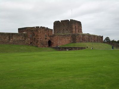
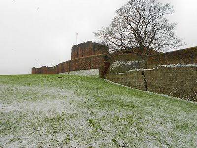
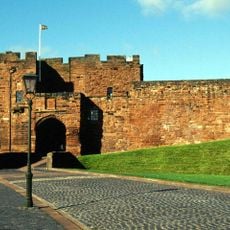
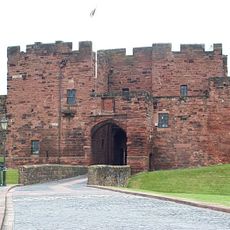
Carlisle Castle, Medieval castle in Carlisle, England
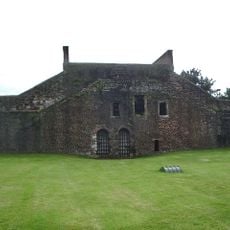
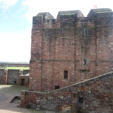
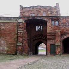
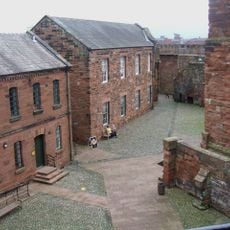
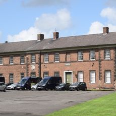
Carlisle Castle is a fortress in northwestern England featuring massive stone walls, a Norman keep, and defensive towers positioned around its fortified compound. The grounds contain various buildings from different periods, showing how the stronghold evolved over centuries.
William II founded the original fortress in 1092 after defeating local leader Dolfin, building it on the remains of a Roman fort. The structure played a key role in border conflicts between England and Scotland over many centuries.
The castle walls hold medieval scratches and carvings left by prisoners during conflicts between England and Scotland. These marks tell stories of people held here who etched their thoughts into the stone.
The site is open to visitors and offers guided tours plus information about medieval military architecture. It is helpful to check ahead before arriving to see if interior spaces are available, as certain areas may sometimes be closed.
The fortress endured an eight-month parliamentary siege in 1644 during the English Civil War, leading to the surrender of Royalist forces. This event left marks on the structure and history of the place that visitors can still trace today.
Location: Carlisle
Inception: 1093
Architectural style: Norman architecture
Website: https://english-heritage.org.uk/visit/places/carlisle-castle
GPS coordinates: 54.89720,-2.94167
Latest update: December 17, 2025 11:19
Tullie House Museum and Art Gallery
235 m
Market Hall
356 m
Statue of Queen Victoria
230 m
West City Walls and Tile Tower adjoining at south-west
138 m
Outer Bailey Half Moon Battery, Flanking Wall And Bridge
1 m
Inner Bailey Keep
44 m
Methodist Central Hall
294 m
De Irebys Tower And Outer Bailey Wall
45 m
3 And 5, Fisher Street
210 m
Wall, Gates And Railings In Front Of Tullie House
254 m
4 And 5, Paternoster Row
266 m
Captains Tower And Inner Bailey Walls
16 m
No 3 And Adjacent Outbuildings
271 m
6, Paternoster Row
266 m
Bridge Over Outer Moat
56 m
1 and 3, Abbey Street
186 m
Inner Bailey Palace Range Including Part Of Queen Mary's Tower
67 m
Outer Bailey Arnhem Block
66 m
Abbey Court
276 m
4, 6 And 8, Fisher Street
186 m
21, Castle Street
261 m
9, Fisher Street
244 m
Outer Bailey Arroyo Block, Gym And Regimental Association Club
78 m
15A, Abbey Street
269 m
17 And 19, Abbey Street
278 m
7, Paternoster Row
266 m
11, Fisher Street
270 m
City Boundary Stone At Ny 3993 5645
300 mVisited this place? Tap the stars to rate it and share your experience / photos with the community! Try now! You can cancel it anytime.
Discover hidden gems everywhere you go!
From secret cafés to breathtaking viewpoints, skip the crowded tourist spots and find places that match your style. Our app makes it easy with voice search, smart filtering, route optimization, and insider tips from travelers worldwide. Download now for the complete mobile experience.
A unique approach to discovering new places❞
— Le Figaro
All the places worth exploring❞
— France Info
A tailor-made excursion in just a few clicks❞
— 20 Minutes