Old Sarum, Archaeological site and Norman castle in Salisbury, England
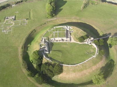
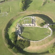
Old Sarum is an archaeological site and Norman castle in Salisbury, England, with extensive earthworks and foundations on a hilltop. The cathedral outline lies within the inner rampart, while the castle remains occupy the highest point and overlook the surrounding plain.
The fort began in the fourth century before Christ as a hillfort and was later settled by Roman troops. After the Norman conquest, the new rulers built a royal castle here and moved the bishop's seat from Sherborne, before everything relocated to New Salisbury in the thirteenth century.
The name Sarum comes from a medieval shortening of the Latin Sarisburia and remains in use today. Visitors find here traces of the separation between castle and church, visible in distinct areas on the hill that speak of the tension between secular and spiritual power.
The path leads uphill over grassy ground, so sturdy shoes are recommended, especially in wet weather. Information panels on site explain the meaning of visible structures and help with orientation between the different areas.
The site remained a parliamentary constituency into the nineteenth century, even though no residents lived here anymore. These so-called rotten boroughs were notorious for allowing individual landowners to effectively appoint members of Parliament, until electoral reform ended the practice.
Location: Salisbury
Operator: English Heritage
Website: https://english-heritage.org.uk/visit/places/old-sarum
GPS coordinates: 51.09333,-1.80472
Latest update: December 4, 2025 23:05
Old Sarum Castle
88 m
Little Durnford Manor
2 km
Raymond McEnhill Stadium
1.8 km
Salisbury Law Courts
2.3 km
St Lawrence, Stratford-sub-Castle
743 m
St Francis's Church, Salisbury
1.3 km
Boscombe Down Aviation Collection
1.5 km
Statue of Sidney Herbert
1.5 km
Emmanuel Free Evangelical Church
2.3 km
Milestone Immediately West Of Church Of St Francis Of Assisi
1.3 km
Little Thatches Old Forge Cottage
665 m
Stratford-sub-Castle War Memorial
767 m
Post Office And Shop
664 m
Prebendal House
744 m
Orchard House
781 m
Church Close
865 m
Boundary Wall To East Of Parsonage Farmhouse, Along Garden By Road
648 m
Parsonage Farmhouse
673 m
Forecourt Wall To Marwarden Court And St Lawrence Reading Road
756 m
Dean's Farmhouse
812 m
Milestone About 300 Metres North Of Longhedge Farm
2.1 km
142 And 144, Castle Street
2.3 km
Milford Hall
2.1 km
Milestone, Devizes Road, Bemerton; opp. No 224
1.9 km
Milepost, Bishopdown
2.2 km
Milestone, Devizes Road, Bemerton Heath; 250m S Fugglestone Red roundabout
1.5 km
Milestone, Amesbury Road; 100m S Stratford turn
612 m
Cottage Approximately 173 Yards To North Of Old Laundry On Same Side Of Road
782 mVisited this place? Tap the stars to rate it and share your experience / photos with the community! Try now! You can cancel it anytime.
Discover hidden gems everywhere you go!
From secret cafés to breathtaking viewpoints, skip the crowded tourist spots and find places that match your style. Our app makes it easy with voice search, smart filtering, route optimization, and insider tips from travelers worldwide. Download now for the complete mobile experience.
A unique approach to discovering new places❞
— Le Figaro
All the places worth exploring❞
— France Info
A tailor-made excursion in just a few clicks❞
— 20 Minutes