Pembroke Dock

Log in to your account

AroundUs is a community-driven map of interesting places, built by curious explorers like you. It grows with every review, story, and photo you share.
Connect to save your favorite spots, contribute locations, and create personalized routes.
Continue with Google
Continue with Apple
Continue with X
Continue with Facebook
Continue with email
By continuing, you accept our Terms and Conditions and our Privacy Policy
Create an account
Add to collection
Map
Suggest a change
Share

Pembroke Dock, Naval port town in Pembrokeshire, Wales.

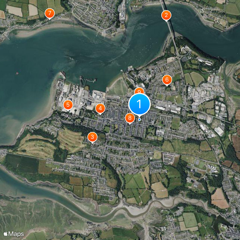
Pembroke Dock is a harbor town on the southern shore of Milford Haven, featuring a grid-pattern street layout with industrial and maritime buildings positioned near the waterfront. The place retains structures from its days as a naval center, with various buildings spread along the coast reflecting different periods of development.

The town was founded in 1814 when a Royal Navy Dockyard was established where a small fishing settlement once stood. The shipyard became a major production center for naval vessels and royal yachts until shipbuilding gradually declined during the 20th century.

The town's name reflects its Norman heritage and deep connection to the sea. Locals take pride in the maritime past, and reminders of the shipyard era remain visible in the waterfront's character and the conversations of residents who recall the busier decades.

The town connects to Ireland via a ferry service and has a railway station with trains to major Welsh cities. The waterfront is best explored at low tide when more of the harbor and its structures become visible to visitors.

During World War II the town hosted one of the largest Allied flying boat bases in the world, from which hundreds of missions were launched against enemy vessels. Remnants of bunkers and reinforced structures from that military period can still be spotted in various parts of the town.

Location: Pembrokeshire

GPS coordinates: 51.69222,-4.93990

Latest update: December 20, 2025 13:12

Photos
Around this place
Cleddau Bridge
United Kingdom

Cleddau Bridge

1.6 km
Defensible Barracks, Pembroke Dock
United Kingdom

Defensible Barracks, Pembroke Dock

838 m
Dockyard Chapel
United Kingdom

Dockyard Chapel

633 m
Paterchurch Tower
United Kingdom

Paterchurch Tower

1.2 km
Pembroke Dock Military Cemetery
United Kingdom

Pembroke Dock Military Cemetery

696 m
St Tudwal's Church
United Kingdom

St Tudwal's Church

2.2 km
Church of Saint John The Evangelist, Bush Street (S Side)
United Kingdom

Church of Saint John The Evangelist, Bush Street (S Side)

167 m
Pembroke Dock Library
United Kingdom

Pembroke Dock Library

341 m
Pembroke Dock Heritage Centre
United Kingdom

Pembroke Dock Heritage Centre

644 m
The War Memorial, Bush Street (S Side)
United Kingdom

The War Memorial, Bush Street (S Side)

145 m
Meyrick Street Methodist Chapel
United Kingdom

Meyrick Street Methodist Chapel

239 m
North East Martello Tower, Front Street (n Side)
United Kingdom

North East Martello Tower, Front Street (n Side)

680 m
United Kingdom

The Graving Dock Including Bollards And Cpstans (formerly Listed With 13 Building Slips And Carr Jet

1.2 km
United Kingdom

The Port Hotel , The Dockyard

920 m
United Kingdom

The Defensible Barracks Presely View (w End)

881 m
The South West Martello Tower, Fort Road (w End)
United Kingdom

The South West Martello Tower, Fort Road (w End)

1.4 km
Former Guard House, The Dockyard
United Kingdom

Former Guard House, The Dockyard

906 m
United Kingdom

No 2, The Terrace, The Dockyard

850 m
United Kingdom

Dockyard Gates, The Dockyard

888 m
United Kingdom

No 1, The Terrace (formerly Listed Together With The Commodore Club)

878 m
United Kingdom

The Old Storehouse (formerly Listed As Main Stores Of R Hayes Investments Ltd), The Dockyard

956 m
United Kingdom

Dovecote In Field To Nw Of Priory Farmhouse

1.8 km
United Kingdom

Forecourt, Railings, Piers And Gates, Meyrick Street (w Side)

219 m
United Kingdom

No 3, The Terrace, The Dockyard

839 m
United Kingdom

Long Stable Range To S, The Dockyard

922 m
United Kingdom

Piers And Lodges (formerly Listed With Dockyard Wall), The Dockyard

904 m
United Kingdom

Barracks Platform, Presely View (w Side)

881 m
United Kingdom

Dry-moat Walls, Presely View (w End)

881 m
Show the full map
Reviews

Visited this place? Tap the stars to rate it and share your experience / photos with the community! Try now! You can cancel it anytime.

« Pembroke Dock - Naval port town in Pembrokeshire, Wales » is provided by Around Us (aroundus.com). Images and texts are derived from Wikimedia project under a Creative Commons license. You are allowed to copy, distribute, and modify copies of this page, under the conditions set by the license, as long as this note is clearly visible.

Discover hidden gems everywhere you go!

From secret cafés to breathtaking viewpoints, skip the crowded tourist spots and find places that match your style. Our app makes it easy with voice search, smart filtering, route optimization, and insider tips from travelers worldwide. Download now for the complete mobile experience.

Around Us App Screenshot

A unique approach to discovering new places

Le Figaro

All the places worth exploring

France Info

A tailor-made excursion in just a few clicks

20 Minutes