Castrum Gariannonum, Roman military fort in Norfolk, England
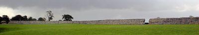
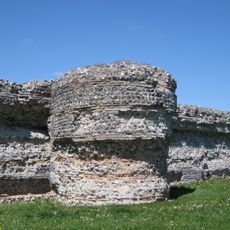
Castrum Gariannonum is a Roman military fort on the eastern coast of England that contains defensive walls, barracks, and storage buildings positioned strategically to monitor sea routes. The site shows several well-preserved foundations and structures that archaeologists continue to examine and research.
The fortress was built in the 2nd century AD and was part of the Saxon Shore defensive system created to protect against sea raids. It remained in operation until the Romans withdrew in the early 5th century.
The fort displays Roman building methods through its regular layout and architectural forms, visible also at other fortifications across Britain. Visitors can observe these standardized structures and understand how the Romans organized their military posts.
The site is located near Caister-on-Sea and is mostly visible as ruins today, with only foundations and excavated structures remaining to see. Visitors should wear sturdy footwear since the ground is uneven and excavation work continues.
The fort housed a specialized cavalry unit called the Equites Stablesiani, which was particularly important for defense against sea attacks. This unit shows how the Romans adapted their troop deployment to the specific threats of the region.
The community of curious travelers
AroundUs brings together thousands of curated places, local tips, and hidden gems, enriched daily by 60,000 contributors worldwide.