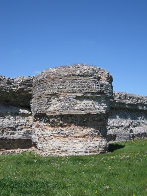
Burgh Castle Roman Site, Roman fortress ruins in Norfolk, England
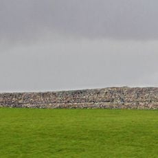
Burgh Castle is a Roman fortress in Norfolk whose three remaining walls reach up to 4.5 meters (15 feet) high and feature original defensive towers along their edges. The ruins spread across a large area and show the typical construction of a late Roman coastal fort with protective structures.
The fortress was built in the late 3rd century to protect the Roman coast from sea raiders and was part of a chain of defensive posts along the eastern shore. After the Romans withdrew, the site was later used by Christian communities.
The site shows signs of early Christian use that emerged from excavations, revealing how the fortress became a refuge after its Roman period ended. Visitors can observe how religious communities repurposed the abandoned walls for their own needs.
The site is freely accessible and offers simple paths for exploring the ruins, with the surroundings flat and open. Visitors should bring weather-resistant clothing as the location is near water and can be windy.
One of the four original walls has disappeared into the marshland of Breydon Water, giving the site an incomplete yet engaging appearance. This missing wall tells its own story of erosion and the passage of time.
Location: Burgh Castle
Part of: Burgh Castle Roman fort, vicus, pre-Conquest monastery and Norman motte and bailey castle
Website: https://english-heritage.org.uk/visit/places/burgh-castle
GPS coordinates: 52.58260,1.65150
Latest update: December 9, 2025 18:42
Castrum Gariannonum
75 m
Berney Arms Windmill
1 km
Halvergate Marshes
2.5 km
Lockgate Mill
2.7 km
Lound Windmill
4.8 km
Mutton's Mill
3.8 km
Berney Marshes RSPB reserve
1.1 km
Lound Lakes
4.9 km
Church of St Peter
5.2 km
Church of St Andrew
5 km
Church of St Peter and St Paul
433 m
Church of St Andrew
4.8 km
Church of St John the Baptist
5.1 km
Church of St Edmund
4.4 km
Church of All Saints
2 km
Church of St Nicholas
2.9 km
Fritton Old Hall
4.4 km
Saint Mary Magdalene
4.5 km
Browston Hall Hotel
3.8 km
Toft Monks (Detached) Windpump
4.5 km
Cadges Mill 160 Metres North East Of Seven Mile House
3.1 km
Polkey's Mill
3.2 km
Kerrisons Level Drainage Mill
4.1 km
Milepost In Front Of Number 245 (Number 245 Not Included)
5.2 km
Caldecott Mill At Tg 465021
2.7 km
Milepost, High Street, Gorleston, by No. 246
5.2 km
Milepost, Beccles Road, Gorleston, S of Whitehorse Roundabout, opp. Jet garage
4.9 km
Milestone, entrance to Upper Warden Lodge
4.9 kmVisited this place? Tap the stars to rate it and share your experience / photos with the community! Try now! You can cancel it anytime.
Discover hidden gems everywhere you go!
From secret cafés to breathtaking viewpoints, skip the crowded tourist spots and find places that match your style. Our app makes it easy with voice search, smart filtering, route optimization, and insider tips from travelers worldwide. Download now for the complete mobile experience.
A unique approach to discovering new places❞
— Le Figaro
All the places worth exploring❞
— France Info
A tailor-made excursion in just a few clicks❞
— 20 Minutes