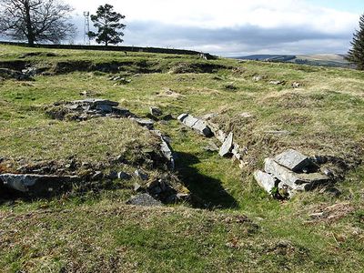
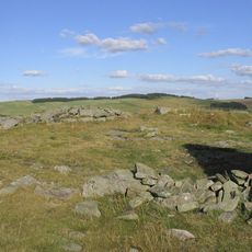
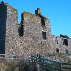
Torwoodlee Broch, Iron Age broch in Caddonfoot, Scotland.
Torwoodlee Broch is a circular stone fortress with a diameter of roughly 23 meters and walls about 5.5 meters thick. The entrance was positioned to shelter from westerly winds, and the interior contained several chambers including a guard room near the entrance.
The fortress dates to the Iron Age and was later used by Romans during the 1st century AD. Archaeological digs in 1891 revealed Roman objects such as pottery, glass, and a coin of Emperor Titus.
The name reflects the ancient woodland that once covered this area and shaped settlement patterns. Visitors can still sense how the surrounding terrain influenced where and how people chose to build.
The site appears as low stone remains today since the walls stand less than 0.5 meters high. Wear sturdy shoes because the terrain is hilly and the large stones are uneven.
An internal chamber near the entrance served as a guard post to watch over access to the fortress. Notably, a separate chamber contained the remains of an ancient staircase that led to higher levels within the structure.
Location: Scottish Borders
Location: Caddonfoot
GPS coordinates: 55.63683,-2.85062
Latest update: December 14, 2025 14:26
Bow Castle Broch
3.3 km
Galashiels Baptist Church
3 km
Torwoodlee House
803 m
St Andrew's Arts Centre (Former Ladhope Free Church), Bridge Street
3.3 km
High Tweed Mill, Former High Tweed Mill, King Street
2.3 km
Bank Of Scotland, 3-7 Channel Street, Galashiels
3.4 km
Workshop & House, Union Street, Galashiels
3.1 km
Walkways And Railings, Steps, 74, 75, 76 Kirk Brae Including Boundary Walls
3 km
Kinloss Abbey and Burial Ground, Abbot's Lodging
723 m
Galashiels, High Street, Head Post Office
3.4 km
Harrow Inn Public House, 22 High Street, Galashiels
3.3 km
2 Channel Street
3.4 km
The Pirns, Former High Tweed Mill, King Street
2.2 km
Gates, St Andrew's Arts Centre (Former Ladhope Free Church), Bridge Street
3.3 km
1-5 Roxburgh Street, Galashiels
3.1 km
2 High Street
3.4 km
4-8 High Street
3.4 km
12 High Street
3.4 km
Boundary Walls And Railings, Former Schoolhouse, 67 Gala Park
3.3 km
Galashiels, High Street, West Relief Church
3.3 km
British Linen Bank, 46-48 High Street, Galashiels
3.3 km
69, 72 (Inclusive) Kirk Brae
3 km
73, 77 (Inclusive) Kirk Brae
3 km
Buckholm Tower
1.8 km
High Mill, Botany Mill
3.1 km
Botany Lane Block
3.1 km
Roxburgh Street Block
3.2 km
Galashiels, Botany Lane, Glasite Chapel
3.2 kmVisited this place? Tap the stars to rate it and share your experience / photos with the community! Try now! You can cancel it anytime.
Discover hidden gems everywhere you go!
From secret cafés to breathtaking viewpoints, skip the crowded tourist spots and find places that match your style. Our app makes it easy with voice search, smart filtering, route optimization, and insider tips from travelers worldwide. Download now for the complete mobile experience.
A unique approach to discovering new places❞
— Le Figaro
All the places worth exploring❞
— France Info
A tailor-made excursion in just a few clicks❞
— 20 Minutes