Enable Location

We need your location to show you interesting places around you

Discover nearby places

Find interesting locations and hidden gems around you

Precise directions

Get accurate directions and distances to places

Your location is never shared with other users. It's only used when you tap the location button.

Port of Hull

Log in to your account

Start exploring — it's free

Trusted by 67,715 travelers worldwide

Continue with Google
Continue with Apple
or

We will send you a code to connect

By continuing, you accept our Terms and Conditions and our Privacy Policy

Check your inbox

We've sent a pincode in your inbox. Please enter the code below.

Port of Hull
Discussion Reviews 1 Photos
26.5k Popularity

Port of Hull, Maritime port in Kingston upon Hull, United Kingdom

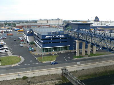
The Port of Hull is a modern port facility at the mouth of the Humber Estuary that stretches for several miles and handles different types of cargo. The landscape is defined by large container yards, grain silos, timber storage areas, and modern terminals where ships are loaded and unloaded throughout the day.

The site began in the 13th century as a wool port founded by monks from Meaux Abbey, and was acquired and renamed Kingston upon Hull by King Edward I in 1293. This renaming marked its rise to prominence as a trading city and made it a crucial center for English exports abroad.

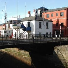
The port retains the name that King Edward I gave it in 1293, and its docks and warehouses shape how locals see their city's identity. Generations have built their lives around the water and trade that flows through this place.

The port sits on the banks of the Humber and is best explored on foot, particularly the publicly accessible areas along the docks. Visitors should note that many working areas are restricted and you should stay on designated public paths.

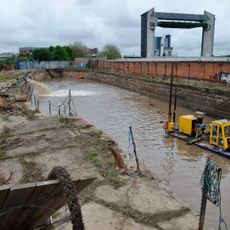
A section of the old docks has been transformed into Green Port Hull, where offshore wind turbines for North Sea wind farms are now manufactured. This shift shows how the port has evolved from traditional cargo handling to clean energy production.

The community of curious travelers

AroundUs brings together thousands of curated places, local tips, and hidden gems, enriched daily by 60,000 contributors worldwide.

Start exploring
GPS coordinates
53.73800,-0.33200
Latest update
December 20, 2025 15:01
Around this place
The Deep
United Kingdom

The Deep

117 m
Hull Minster
United Kingdom

Hull Minster

442 m
Tidal Surge Barrier, River Hull
United Kingdom

Tidal Surge Barrier, River Hull

228 m
World Trade Centre Hull & Humber
United Kingdom

World Trade Centre Hull & Humber

385 m
Humber Street Gallery
United Kingdom

Humber Street Gallery

210 m
Dinostar
United Kingdom

Dinostar

214 m
Statue of Andrew Marvell on North Side of South Church Side
United Kingdom

Statue of Andrew Marvell on North Side of South Church Side

473 m
Equestrian statue of William III
United Kingdom

Equestrian statue of William III

358 m
Minerva Hotel
United Kingdom

Minerva Hotel

195 m
Hepworths Arcade
United Kingdom

Hepworths Arcade

500 m
Public Toilets To North Of King William Iii Statue
United Kingdom

Public Toilets To North Of King William Iii Statue

367 m
Former Corporation Pier Station
United Kingdom

Former Corporation Pier Station

145 m
Humber Dock And Swing Bridge And Lock At South Entrance
United Kingdom

Humber Dock And Swing Bridge And Lock At South Entrance

325 m
9 1/2 10 10 1/2 And 11, King Street
United Kingdom

9 1/2 10 10 1/2 And 11, King Street

497 m
The Market Hall And Bob Carvers Fish And Chip Restaurant
United Kingdom

The Market Hall And Bob Carvers Fish And Chip Restaurant

495 m
Wool Exchange
United Kingdom

Wool Exchange

445 m
K1 Telephone Kiosk In Market Hall
United Kingdom

K1 Telephone Kiosk In Market Hall

491 m
Former Pilot Office
United Kingdom

Former Pilot Office

110 m
Building Between Kings Market And Wool Exchange
United Kingdom

Building Between Kings Market And Wool Exchange

434 m
Electric Street Lamp At South West Corner Of Holy Trinity Churchyard
United Kingdom

Electric Street Lamp At South West Corner Of Holy Trinity Churchyard

462 m
Electric Street Lamp At North West Corner Of Holy Trinity Churchyard
United Kingdom

Electric Street Lamp At North West Corner Of Holy Trinity Churchyard

495 m
Central Dry Dock/ Sand Southend Wharf
United Kingdom

Central Dry Dock/ Sand Southend Wharf

174 m
Kings Market
United Kingdom

Kings Market

422 m
Public Conveniences, Nelson Street
United Kingdom

Public Conveniences, Nelson Street

164 m
Statue of William de-la-Pole
United Kingdom

Statue of William de-la-Pole

88 m
Former Fish Street Day Schools
United Kingdom

Former Fish Street Day Schools

468 m
Kingston Upon Hull Naval Memorial
United Kingdom

Kingston Upon Hull Naval Memorial

202 m
Old Grammar School Museum
United Kingdom

Old Grammar School Museum

452 m
Show the full map
Reviews
Share your experience

No review yet

Discussions
Start a discussion...

No discussion yet

« Port of Hull - Maritime port in Kingston upon Hull, United Kingdom » is provided by Around Us (aroundus.com). Images and texts are derived from Wikimedia project under a Creative Commons license. You are allowed to copy, distribute, and modify copies of this page, under the conditions set by the license, as long as this note is clearly visible.

Discover hidden gems everywhere you go!

From secret cafés to breathtaking viewpoints, skip the crowded tourist spots and find places that match your style. Our app makes it easy with voice search, smart filtering, route optimization, and insider tips from travelers worldwide. Download now for the complete mobile experience.

Around Us App Screenshot

A unique approach to discovering new places

Le Figaro

All the places worth exploring

France Info

A tailor-made excursion in just a few clicks

20 Minutes

Around Us
Travel Guide & Maps
Download

Send to your phone

QR Code
1

Open the camera app on your mobile.

2

Point at the QR code with your camera. A notification will appear.

3

Tap the notification to open the link.