Enable Location

We need your location to show you interesting places around you

Discover nearby places

Find interesting locations and hidden gems around you

Precise directions

Get accurate directions and distances to places

Your location is never shared with other users. It's only used when you tap the location button.

Struell Wells

Log in to your account

Start exploring — it's free

Trusted by 62,470 travelers worldwide

Continue with Google
Continue with Apple
or

We will send you a code to connect

By continuing, you accept our Terms and Conditions and our Privacy Policy

Check your inbox

We've sent a pincode in your inbox. Please enter the code below.

Struell Wells

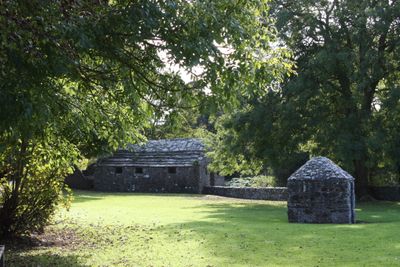
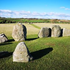
Struell Wells, Holy wells archaeological site near Downpatrick, Northern Ireland.

Struell Wells is an archaeological site with four stone-built wells and bathhouses located in a secluded valley near Downpatrick. A fast-flowing stream runs partially underground through the complex, creating a natural water system that serves the separate facilities for men and women, along with the remains of an unfinished church.

The wells predate Saint Patrick's era, though the first documented reference appeared in 1306. The structures visible today date from around 1600, showing how the site evolved and was formalized over centuries.

Pilgrims traditionally gathered at the wells on Saint John's Eve and the Friday before Lammas, seeking physical and spiritual healing. The site became a place where visitors performed specific rituals at different wells, each associated with different parts of the body.

The site is maintained by the Northern Ireland Environment Agency and offers free public access. The valley terrain can be damp, so sturdy footwear is advisable when walking through the grounds.

The site features specialized wells including the Mother Well for drinking and an eye well, each used for different healing purposes. This distinction between wells reveals a detailed system of healing beliefs that developed at this location.

The community of curious travelers

AroundUs brings together thousands of curated places, local tips, and hidden gems, enriched daily by 60,000 contributors worldwide.

Start exploring
GPS coordinates
54.32380,-5.67671
Latest update
December 12, 2025 12:02
Around this place
Castle Ward
United Kingdom

Castle Ward

7.9 km
Down Cathedral
United Kingdom

Down Cathedral

3 km
Downpatrick and County Down Railway
United Kingdom

Downpatrick and County Down Railway

3 km
Inch Abbey
United Kingdom

Inch Abbey

3.8 km
Jordan's Castle
United Kingdom

Jordan's Castle

8.4 km
Quoile Castle
United Kingdom

Quoile Castle

3.2 km
Kilclief Castle
United Kingdom

Kilclief Castle

8 km
Downpatrick Courthouse
United Kingdom

Downpatrick Courthouse

2.8 km
Audleystown Court Cairn
United Kingdom

Audleystown Court Cairn

7.6 km
Bright Castle
United Kingdom

Bright Castle

5.5 km
Quoile Bridge
United Kingdom

Quoile Bridge

3.9 km
Down Arts Centre
United Kingdom

Down Arts Centre

2.6 km
The Meadow, Downpatrick
United Kingdom

The Meadow, Downpatrick

2.9 km
Ballynoe Stone Circle
United Kingdom

Ballynoe Stone Circle

4.9 km
Down County Museum
United Kingdom

Down County Museum

2.9 km
St. Patrick's Memorial C Of I Church, Saul Strangford Downpatrick Co.down
United Kingdom

St. Patrick's Memorial C Of I Church, Saul Strangford Downpatrick Co.down

2.2 km
Christ Church Drumroe Road Ballyculter Upper Strangford Downpatrick Co.down
United Kingdom

Christ Church Drumroe Road Ballyculter Upper Strangford Downpatrick Co.down

6.8 km
Southwell Charity School And Almshouses English St. Downpatrick Co.down
United Kingdom

Southwell Charity School And Almshouses English St. Downpatrick Co.down

2.9 km
Eclipse Cinema
United Kingdom

Eclipse Cinema

3 km
Marlborough House 64 Killough Road Ballymote Middle Downpatrick Co Down Bt30 8bl
United Kingdom

Marlborough House 64 Killough Road Ballymote Middle Downpatrick Co Down Bt30 8bl

2.4 km
Gatehouse New County Gaol Downpatrick Co.down
United Kingdom

Gatehouse New County Gaol Downpatrick Co.down

2.8 km
Old Castle Ward
United Kingdom

Old Castle Ward

8.4 km
27 English St. Downpatrick Co.down
United Kingdom

27 English St. Downpatrick Co.down

2.9 km
25 English St. Downpatrick Co.down
United Kingdom

25 English St. Downpatrick Co.down

2.9 km
Downpatrick First (non-subscribing) Presbyterian Church Stream Street Downpatrick Co Down Bt30 6dd
United Kingdom

Downpatrick First (non-subscribing) Presbyterian Church Stream Street Downpatrick Co Down Bt30 6dd

2.3 km
Percival-maxwell Tomb Inch Parish Churchyard Inch Downpatrick Co.down
United Kingdom

Percival-maxwell Tomb Inch Parish Churchyard Inch Downpatrick Co.down

3.8 km
Flour Or Corn Mill Castleward House Castleward Strangford Downpatrick Co.down
United Kingdom

Flour Or Corn Mill Castleward House Castleward Strangford Downpatrick Co.down

8.4 km
Court House, English St. Downpatrick Co.down
United Kingdom

Court House, English St. Downpatrick Co.down

2.8 km
Show the full map
« Struell Wells - Holy wells archaeological site near Downpatrick, Northern Ireland » is provided by Around Us (aroundus.com). Images and texts are derived from Wikimedia project under a Creative Commons license. You are allowed to copy, distribute, and modify copies of this page, under the conditions set by the license, as long as this note is clearly visible.

Discover hidden gems everywhere you go!

From secret cafés to breathtaking viewpoints, skip the crowded tourist spots and find places that match your style. Our app makes it easy with voice search, smart filtering, route optimization, and insider tips from travelers worldwide. Download now for the complete mobile experience.

Around Us App Screenshot

A unique approach to discovering new places

Le Figaro

All the places worth exploring

France Info

A tailor-made excursion in just a few clicks

20 Minutes

Around Us
Travel Guide & Maps
Download

Send to your phone

QR Code
1

Open the camera app on your mobile.

2

Point at the QR code with your camera. A notification will appear.

3

Tap the notification to open the link.