Enable Location

We need your location to show you interesting places around you

Discover nearby places

Find interesting locations and hidden gems around you

Precise directions

Get accurate directions and distances to places

Your location is never shared with other users. It's only used when you tap the location button.

Gisborough Priory

Log in to your account

Start exploring — it's free

Trusted by 62,539 travelers worldwide

Continue with Google
Continue with Apple
or

We will send you a code to connect

By continuing, you accept our Terms and Conditions and our Privacy Policy

Check your inbox

We've sent a pincode in your inbox. Please enter the code below.

Gisborough Priory

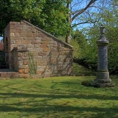
Gisborough Priory, Augustinian monastery ruins in Guisborough, England

Gisborough Priory is a monastery site in Guisborough whose remains include a massive Gothic east window that rises from the ground. The ruins show thick stone walls and architectural details from centuries of construction and use as a religious house.

The priory was founded in 1119 and grew to become a significant Augustinian monastery in England. A major fire in 1289 destroyed the church and caused the loss of important manuscripts and valuable objects.

Medieval education at the priory included a dedicated master who taught music and religious studies to children from impoverished families.

The site is open to visitors year-round and can be explored at your own pace through the ruins. Wear sturdy shoes as the ground is uneven and the location can be quite exposed to wind.

The 1289 fire that destroyed the second priory church started from a plumber's error, resulting in the loss of theological manuscripts and precious artifacts.

The community of curious travelers

AroundUs brings together thousands of curated places, local tips, and hidden gems, enriched daily by 60,000 contributors worldwide.

Start exploring
Location
Inception
12 century
Architects
Robert de Brus, 1st Lord of Annandale
GPS coordinates
54.53620,-1.04722
Latest update
January 25, 2026 19:18
Around this place
Gisborough Hall
United Kingdom

Gisborough Hall

725 m
Hutton Hall
United Kingdom

Hutton Hall

2.4 km
Guisborough Town Hall
United Kingdom

Guisborough Town Hall

276 m
Ruther Cross
United Kingdom

Ruther Cross

1.7 km
Church of St Nicholas
United Kingdom

Church of St Nicholas

107 m
Old Church of St Andrew
United Kingdom

Old Church of St Andrew

3.8 km
Church of St Andrew
United Kingdom

Church of St Andrew

3.7 km
Guisborough War Memorial
United Kingdom

Guisborough War Memorial

143 m
Slapewath Viaduct
United Kingdom

Slapewath Viaduct

1.9 km
Fairworld Cinema
United Kingdom

Fairworld Cinema

438 m
Boundary Stone, Circa 475 Metres East Of Aysdalegate Farmhouse
United Kingdom

Boundary Stone, Circa 475 Metres East Of Aysdalegate Farmhouse

4 km
Tocketts Mill
United Kingdom

Tocketts Mill

2.2 km
Upleatham War Memorial
United Kingdom

Upleatham War Memorial

3.6 km
Hob Cross Approximately 875 Metres To South Of Tidkinhow Farmhouse At Ngr Nz645 133
United Kingdom

Hob Cross Approximately 875 Metres To South Of Tidkinhow Farmhouse At Ngr Nz645 133

3.9 km
The Black Swan
United Kingdom

The Black Swan

313 m
St Mary's Priory gatehouse
United Kingdom

St Mary's Priory gatehouse

148 m
Explosives Magazine For Skelton Shaft Iron Mines
United Kingdom

Explosives Magazine For Skelton Shaft Iron Mines

2.4 km
Guide Post
United Kingdom

Guide Post

1.1 km
Market Cross And Drinking Fountain
United Kingdom

Market Cross And Drinking Fountain

249 m
Priory Dovecote, To West Of St Mary's Priory Ruins
United Kingdom

Priory Dovecote, To West Of St Mary's Priory Ruins

151 m
Guibal Fanhouse At Skelton Shaft Iron Mine
United Kingdom

Guibal Fanhouse At Skelton Shaft Iron Mine

2.1 km
Boundary Stone Approximately 550 Metres South West Of Tidkinhow Farmhouse At Ngr Nz643 137
United Kingdom

Boundary Stone Approximately 550 Metres South West Of Tidkinhow Farmhouse At Ngr Nz643 137

3.5 km
Boundary Stone Approximately 1225 Metres To South Of Highcliff Farmhouse At Ngr Nz605 121
United Kingdom

Boundary Stone Approximately 1225 Metres To South Of Highcliff Farmhouse At Ngr Nz605 121

4 km
Boundary Stone, Circa 350 Metres South East Of Aysdalegate Farmhouse
United Kingdom

Boundary Stone, Circa 350 Metres South East Of Aysdalegate Farmhouse

3.9 km
Gisborough Priory Augustinian monastery: late Saxon settlement, cemetery, monastic precinct and dovecote
United Kingdom

Gisborough Priory Augustinian monastery: late Saxon settlement, cemetery, monastic precinct and dovecote

90 m
Estate Office, Former Joiner's Workshop To West Of Home Farmhouse
United Kingdom

Estate Office, Former Joiner's Workshop To West Of Home Farmhouse

2.8 km
Dunsdale War Memorial
United Kingdom

Dunsdale War Memorial

3 km
Milestone, Birk Brow Road(bottom)
United Kingdom

Milestone, Birk Brow Road(bottom)

3.3 km
Show the full map
« Gisborough Priory - Augustinian monastery ruins in Guisborough, England » is provided by Around Us (aroundus.com). Images and texts are derived from Wikimedia project under a Creative Commons license. You are allowed to copy, distribute, and modify copies of this page, under the conditions set by the license, as long as this note is clearly visible.

Discover hidden gems everywhere you go!

From secret cafés to breathtaking viewpoints, skip the crowded tourist spots and find places that match your style. Our app makes it easy with voice search, smart filtering, route optimization, and insider tips from travelers worldwide. Download now for the complete mobile experience.

Around Us App Screenshot

A unique approach to discovering new places

Le Figaro

All the places worth exploring

France Info

A tailor-made excursion in just a few clicks

20 Minutes

Around Us
Travel Guide & Maps
Download

Send to your phone

QR Code
1

Open the camera app on your mobile.

2

Point at the QR code with your camera. A notification will appear.

3

Tap the notification to open the link.