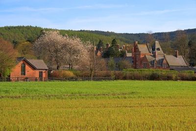
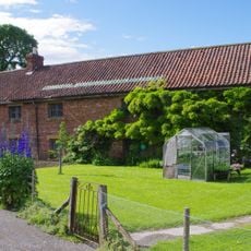
Hutton Hall, Victorian country house in Guisborough, England
The red brick building features stone dressings, slate roofs, and a seven-bay south facade with a conservatory on the east side.
Alfred Waterhouse constructed this Grade II listed building in 1866 for Joseph Pease, a Quaker industrialist and member of parliament.
The estate included 113 hectares of parkland with a kitchen garden, fernery, shrubbery, waterfalls, streams, and bridges designed by James Pulham.
The property maintains 13.5 acres of its original estate, with the Middlesbrough to Guisborough railway line forming the northern boundary.
During the Spanish Civil War, the hall served as accommodation for Spanish nuns and Basque refugees, with 20 children arriving in July 1937.
Location: Guisborough
GPS coordinates: 54.52220,-1.07570
Latest update: March 5, 2025 23:09
Gisborough Priory
2.4 km
Guisborough Town Hall
2.2 km
Ruther Cross
698 m
Church of St Nicholas
2.4 km
Guisborough War Memorial
2.3 km
Fairworld Cinema
2 km
St Mary's Priory gatehouse
2.3 km
Pair Of Boundary Stones, Approximately 2025 Metres To South Of Home Lowcross At Ngr Nz599 123
2.1 km
The Black Swan
2.2 km
Market Cross And Drinking Fountain
2.2 km
Boundary Stone, Approximately 1700 Metres To South Of Home Farmhouse, Hutton Lowcross At Ngr Nz595 126
1.9 km
Boundary Stone, Approximately 330 Metres South West Of Pinchinthorpe Hall At Ngr Nz74137
2.6 km
Boundary Stone, Approximately 1350 Metres To South Of Highcliff Farmhouse At Ngr Nz604 120
2.5 km
Boundary Stone, Approximately 1950 Metres To South Of Home Farmhouse Hutton Lowcross At Ngr Nz595 124
2.1 km
Boundary Stone Approximately 1300 Metres To South Of Highcliff Farmhouse At Ngr Nz603 121
2.4 km
Boundary Stone Approximately 1600 Metres To South Of Home Farmhouse, Hutton Lowcross At Ngr Nz593 127
1.8 km
Priory Dovecote, To West Of St Mary's Priory Ruins
2.3 km
Boundary Stone, Approximately 1310 Metres To South Of Highcliff Farmhouse At Ngr Nz605 121
2.5 km
Boundary Stone Approximately 400 Metres To South Of Highcliff Farmhouse At Ngr Nz606 119
2.6 km
Boundary Stone Approximately 1260 Metres To South Of Highcliff Farmhouse At Ngr Nz605 121
2.4 km
Boundary Stone, Approximately 1630 Metres To South West Of Home Farmhouse Hutton Lowcross At Ngr Nz588 129
1.9 km
Boundary Stone, Approximately 1300 Metres To South West Of Highcliff Farmhouse At Ngr Nz600 123
2.2 km
Boundary Stone, Approximately 1990 Metres To South Of Home Farmhouse, Hutton Lowcross At Ngr Nz592 123
2.2 km
Boundary Stone Approximately 1225 Metres To South Of Highcliff Farmhouse At Ngr Nz605 121
2.3 km
Boundary Stone Approximately 1940 Metres To South Of Home Farmhouse Hutton Lowcross At Ngr Nz595 124
2.1 km
Boundary Stone, Approximately 1430 Metres To South Of Highcliff Farmhouse At Ngr Nz605 119
2.6 km
Gisborough Priory Augustinian monastery: late Saxon settlement, cemetery, monastic precinct and dovecote
2.3 km
Estate Office, Former Joiner's Workshop To West Of Home Farmhouse
416 mReviews
Visited this place? Tap the stars to rate it and share your experience / photos with the community! Try now! You can cancel it anytime.
Discover hidden gems everywhere you go!
From secret cafés to breathtaking viewpoints, skip the crowded tourist spots and find places that match your style. Our app makes it easy with voice search, smart filtering, route optimization, and insider tips from travelers worldwide. Download now for the complete mobile experience.
A unique approach to discovering new places❞
— Le Figaro
All the places worth exploring❞
— France Info
A tailor-made excursion in just a few clicks❞
— 20 Minutes