Enable Location

We need your location to show you interesting places around you

Discover nearby places

Find interesting locations and hidden gems around you

Precise directions

Get accurate directions and distances to places

Your location is never shared with other users. It's only used when you tap the location button.

Binevenagh

Log in to your account

Start exploring — it's free

Trusted by 62,490 travelers worldwide

Continue with Google
Continue with Apple
or

We will send you a code to connect

By continuing, you accept our Terms and Conditions and our Privacy Policy

Check your inbox

We've sent a pincode in your inbox. Please enter the code below.

Binevenagh, Mountain and Area of Outstanding Natural Beauty in County Londonderry, Northern Ireland.

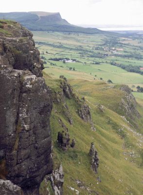
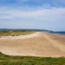
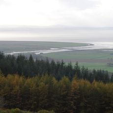
Binevenagh is a mountain and Area of Outstanding Natural Beauty in County Londonderry with steep cliffs overlooking Lough Foyle and the Magilligan peninsula. The summit reaches 385 meters and forms the western edge of the Antrim Plateau with a distinctive ridge formation.

The geological formation emerged around 60 million years ago through volcanic activity that created the distinctive plateau structure of the region. These volcanic events shaped not only the landform but also the rock composition of the entire area.

The name comes from Irish 'Binn Fhoibhne', meaning Foibhne's peak, showing how the landscape has been connected to local Celtic heritage for generations. This place name reflects how communities have always identified themselves through the natural features around them.

Access to the summit starts from Leighery Road, where a parking area near a sharp bend leads to forest trails climbing toward the top. Visitors should wear sturdy footwear and be prepared for changing weather, as the elevation brings conditions that can shift rapidly.

An artificial lake at the summit serves as a trout fishery, creating an unexpected calm spot on the mountain top. The slopes also function as launch sites for the Ulster Gliding Club, where gliders take flight from this location.

The community of curious travelers

AroundUs brings together thousands of curated places, local tips, and hidden gems, enriched daily by 60,000 contributors worldwide.

Start exploring
Elevation above the sea
385 m
GPS coordinates
55.11421,-6.91638
Latest update
December 10, 2025 15:46
Around this place
Mussenden Temple
United Kingdom

Mussenden Temple

9 km
Downhill House
United Kingdom

Downhill House

8.7 km
Roe Valley Country Park
United Kingdom

Roe Valley Country Park

10 km
Portstewart Strand
United Kingdom

Portstewart Strand

12.4 km
Northburgh Castle
Ireland

Northburgh Castle

10.8 km
Liffock House
United Kingdom

Liffock House

9.3 km
Portstewart Town Hall
United Kingdom

Portstewart Town Hall

14.7 km
Roe Valley Arts & Cultural Centre
United Kingdom

Roe Valley Arts & Cultural Centre

7.3 km
Roe Estuary Nature Reserve
United Kingdom

Roe Estuary Nature Reserve

4.6 km
Macosquin Abbey
United Kingdom

Macosquin Abbey

12.8 km
Cooly Skull House
Ireland

Cooly Skull House

12.4 km
Inishowen Lighthouse
Ireland

Inishowen Lighthouse

12.5 km
Inishowen Maritime Museum and Planetarium
Ireland

Inishowen Maritime Museum and Planetarium

10.8 km
Warren Point Lighthouse
Ireland

Warren Point Lighthouse

10.9 km
Limavady Baptist Church
United Kingdom

Limavady Baptist Church

7.7 km
Moville Lighthouse
Ireland

Moville Lighthouse

10.8 km
St Finian's Church of Ireland, Redcastle
Ireland

St Finian's Church of Ireland, Redcastle

14.3 km
Cooly Graveyard
Ireland

Cooly Graveyard

12.4 km
Inishowen East Lighthouse
Ireland

Inishowen East Lighthouse

12.5 km
Church of St Pius X, Moville
Ireland

Church of St Pius X, Moville

11.4 km
St Mary's Church, Ballybrack
Ireland

St Mary's Church, Ballybrack

11.3 km
Roe Valley Hospital (former Workhouse) Benevenagh Avenue Limavady Co Londonderry Bt49 Oaq
United Kingdom

Roe Valley Hospital (former Workhouse) Benevenagh Avenue Limavady Co Londonderry Bt49 Oaq

7.6 km
Glebe Bridge
Ireland

Glebe Bridge

12 km
Ballykelly Presbyterian Church Main Street Ballykelly Limavady Co Londonderry Bt49 9hs
United Kingdom

Ballykelly Presbyterian Church Main Street Ballykelly Limavady Co Londonderry Bt49 9hs

10 km
Mausoleum Downhill Demesne Castlerock Co. Londonderry
United Kingdom

Mausoleum Downhill Demesne Castlerock Co. Londonderry

8.6 km
Presbyterian Church Church St./enfield St. Portstewart Co.londonderry
United Kingdom

Presbyterian Church Church St./enfield St. Portstewart Co.londonderry

14.9 km
Martello Tower Point Road Magilligan Limavady Co Londonderry
United Kingdom

Martello Tower Point Road Magilligan Limavady Co Londonderry

9.2 km
Walled Garden & Dovecote / Ice-house Downhill Demesne Seacoast Road Castlerock Co. Londonderry Bt51 4rp
United Kingdom

Walled Garden & Dovecote / Ice-house Downhill Demesne Seacoast Road Castlerock Co. Londonderry Bt51 4rp

8.5 km
Show the full map
« Binevenagh - Mountain and Area of Outstanding Natural Beauty in County Londonderry, Northern Ireland » is provided by Around Us (aroundus.com). Images and texts are derived from Wikimedia project under a Creative Commons license. You are allowed to copy, distribute, and modify copies of this page, under the conditions set by the license, as long as this note is clearly visible.

Discover hidden gems everywhere you go!

From secret cafés to breathtaking viewpoints, skip the crowded tourist spots and find places that match your style. Our app makes it easy with voice search, smart filtering, route optimization, and insider tips from travelers worldwide. Download now for the complete mobile experience.

Around Us App Screenshot

A unique approach to discovering new places

Le Figaro

All the places worth exploring

France Info

A tailor-made excursion in just a few clicks

20 Minutes

Around Us
Travel Guide & Maps
Download

Send to your phone

QR Code
1

Open the camera app on your mobile.

2

Point at the QR code with your camera. A notification will appear.

3

Tap the notification to open the link.