Brimham Rocks

Log in to your account

AroundUs is a community-driven map of interesting places, built by curious explorers like you. It grows with every review, story, and photo you share.
Connect to save your favorite spots, contribute locations, and create personalized routes.
By continuing, you accept our Terms and Conditions and our Privacy Policy

Brimham Rocks, Protected rock formation in North Yorkshire, England
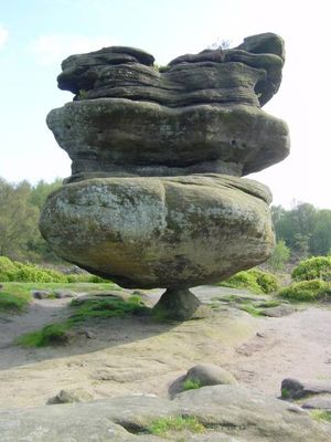
Brimham Rocks features numerous sandstone formations shaped by natural erosion, creating a landscape of stacked stones across 454 acres of moorland terrain.

The rock formations originated 325 million years ago during the Carboniferous period when river-deposited sands in a delta environment formed the Lower Brimham Grit.

Early antiquarians in the 18th century believed the rocks were carved by druids, leading to naming conventions such as Druid's Idol for certain formations.

The site remains open daily from 9 AM until dusk, with parking fees of £6.50 for four hours or £10 for a full day for non-National Trust members.

The protected area contains Yorkshire's largest colonies of bog asphodel and provides habitat for multiple deer species, including red, roe, and sika deer.

Location: North Yorkshire

Website: https://nationaltrust.org.uk/brimham-rocks

GPS coordinates: 54.08083,-1.68556

Latest update: May 27, 2025 06:52

Notable rock formations worldwide

Geological formations created by natural processes over millions of years. These stones and rocks display various shapes: arches, monoliths, spheres, and pillars. From Australia's Uluru to Norway's Kjeragbolten, these formations document Earth's history.

Around this place
Show the full map
Pateley Playhouse
United Kingdom

Pateley Playhouse

4.8 km
Church of St Jude
United Kingdom

Church of St Jude

3.5 km
Church of the Holy Trinity
United Kingdom

Church of the Holy Trinity

2.9 km
The Royal Oak Public House
United Kingdom

The Royal Oak Public House

3.3 km
Dacre Hall
United Kingdom

Dacre Hall

4.4 km
Summer Bridge  Summer Bridge Over River Nidd
United Kingdom

Summer Bridge Summer Bridge Over River Nidd

2.8 km
Ruins of St Mary's Church
United Kingdom

Ruins of St Mary's Church

4.4 km
Braisty Woods Farmhouse
United Kingdom

Braisty Woods Farmhouse

1.7 km
Milestone, High Street/Ripley Bank, Pateley Bridge
United Kingdom

Milestone, High Street/Ripley Bank, Pateley Bridge

4.6 km
Glasshouses Mill
United Kingdom

Glasshouses Mill

3.5 km
Mile Post Approximately 150 Metres East Of Junction With Sawley Moor Lane
United Kingdom

Mile Post Approximately 150 Metres East Of Junction With Sawley Moor Lane

3.6 km
Lacon Cross
United Kingdom

Lacon Cross

4.1 km
Summerbridge House And Attached Walls And Railings
United Kingdom

Summerbridge House And Attached Walls And Railings

2.8 km
Mile Post Approximately 20 Metres To North Of Cliff Top House
United Kingdom

Mile Post Approximately 20 Metres To North Of Cliff Top House

1.7 km
Milestone, Low Laithe
United Kingdom

Milestone, Low Laithe

2.1 km
Pump
United Kingdom

Pump

3.2 km
Knox Hall
United Kingdom

Knox Hall

2 km
Pump At Junction Of Ripon Road
United Kingdom

Pump At Junction Of Ripon Road

4.8 km
Gate Hill Farmhouse
United Kingdom

Gate Hill Farmhouse

3.1 km
58 And 58A, High Street
United Kingdom

58 And 58A, High Street

4.8 km
The Pateley Club
United Kingdom

The Pateley Club

4.8 km
Brimham Lodge
United Kingdom

Brimham Lodge

2.7 km
Sundial In Graveyard Approximately 15 Metres South Of Providence Chapel
United Kingdom

Sundial In Graveyard Approximately 15 Metres South Of Providence Chapel

4.4 km
Bewerley Grange
United Kingdom

Bewerley Grange

4.7 km
Milestone, Summerbridge, nr Flying Dutchman PH; at jct with Hartwith Bank
United Kingdom

Milestone, Summerbridge, nr Flying Dutchman PH; at jct with Hartwith Bank

2.7 km
Mile Post Approximately 50 Metres To The South Of Blazefield
United Kingdom

Mile Post Approximately 50 Metres To The South Of Blazefield

3.3 km
Milestone, W of Stripe Lane
United Kingdom

Milestone, W of Stripe Lane

4.5 km
Milestone, Wilsill, The Raikes
United Kingdom

Milestone, Wilsill, The Raikes

2.6 km
Show the full map

Reviews

Visited this place? Tap the stars to rate it and share your experience / photos with the community! Try now! You can cancel it anytime.

« Brimham Rocks - Protected rock formation in North Yorkshire, England » is provided by Around Us (aroundus.com). Images and texts are derived from Wikimedia project under a Creative Commons license. You are allowed to copy, distribute, and modify copies of this page, under the conditions set by the license, as long as this note is clearly visible.

Discover hidden gems everywhere you go!

From secret cafés to breathtaking viewpoints, skip the crowded tourist spots and find places that match your style. Our app makes it easy with voice search, smart filtering, route optimization, and insider tips from travelers worldwide. Download now for the complete mobile experience.

Around Us App Screenshot

A unique approach to discovering new places

Le Figaro

All the places worth exploring

France Info

A tailor-made excursion in just a few clicks

20 Minutes