See the monuments around you in AROpen chests in the app
Around Us is built for your phone — point your camera at the streets and discover the monuments and places around you in augmented reality.Around Us is built for your phone — chests unlock when you walk, explore and capture nearby places.
Geological formations develop over millions of years through natural processes including erosion, weathering, and tectonic activity. These rocks and stone structures take various forms – arches, monoliths, spheres, and pillars – shaped by wind, water, and time. They document Earth's geological history and provide insight into the forces that have sculpted our planet. From the red sandstone formations of the Australian outback to the granite arches of Central Europe, these sites demonstrate the diversity of geological processes across different climates and landscapes.
The collection includes locations such as Uluru in Australia's Northern Territory, a 1,142-foot (348-meter) sandstone monolith of cultural significance to the Anangu people. In Rogaland, Norway, Kjeragbolten is a boulder wedged between two cliff faces. Pravčická Brána in the Czech Republic's Ústí nad Labem region is Europe's largest natural sandstone arch with a span of 85 feet (26 meters). Other examples include the Moeraki Boulders in New Zealand, nearly spherical stones along the beach, and El Capitan in California, a 2,900-foot (900-meter) granite wall. These formations serve both geological research and as destinations for travelers interested in exploring natural landforms.
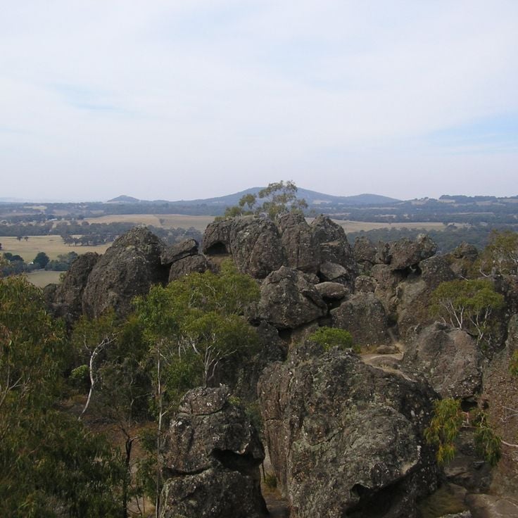
Hanging Rock is a volcanic formation from the Ordovician period with characteristic columns and projections rising 345 feet (105 meters) above the plain. This rock group formed through erosion processes that exposed harder rock layers while softer material eroded away. The formation documents volcanic activity that shaped this region of Australia approximately 450 million years ago and represents geological evidence created by natural processes over extended timeframes.
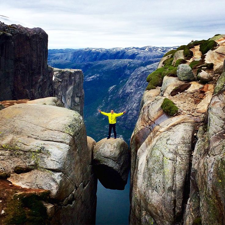
This round granite boulder measuring five meters (16 feet) in diameter has rested at 984 meters (3,228 feet) elevation between two rock faces in the Lysefjord since the last Ice Age, representing one of the most unusual geological formations in Scandinavia where the position of the stone documents glacial movements that occurred during the retreat of glaciers approximately 50,000 years ago, making Kjeragbolten a significant example of the natural processes that have shaped Norwegian fjord landscapes over millions of years.
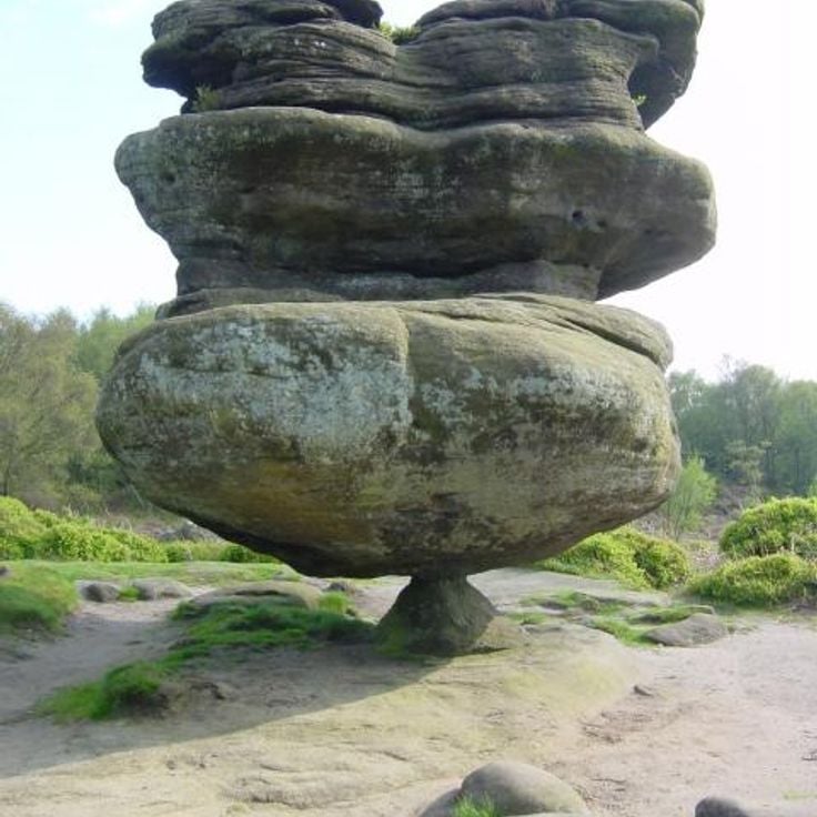
This Millbrook sandstone block weighs 200 tons (180 metric tonnes) and balances on a base measuring only 12 inches (30 centimeters) across at Brimham Moor. The formation represents one of several geological structures created by natural erosion processes over millions of years, documenting this Yorkshire region's geological history through its unusual shape and weight distribution.
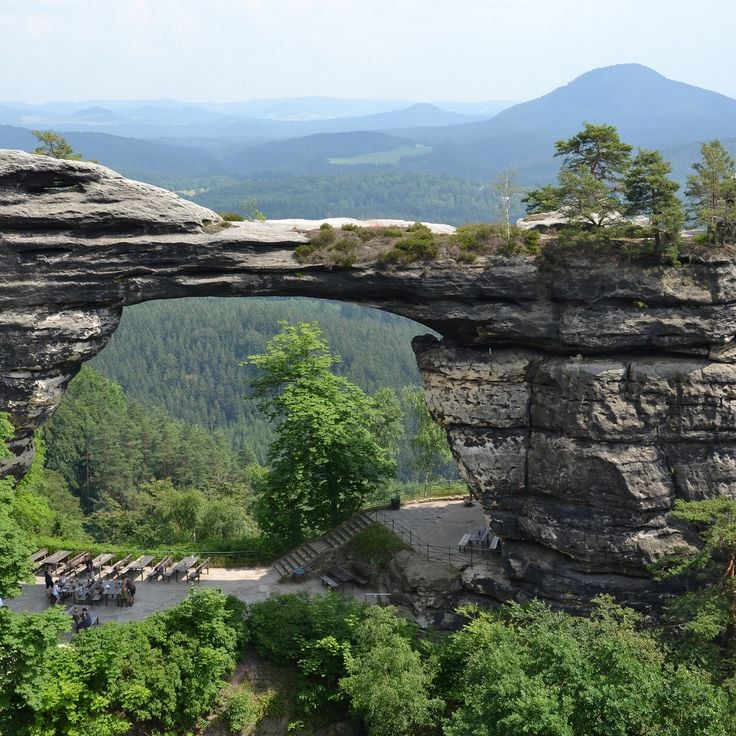
Pravčická Brána is a sandstone arch in the Bohemian Switzerland National Park with a span of 87 feet (26.5 meters), a height of 52 feet (16 meters), and a thickness of 26 feet (8 meters). This natural formation emerged through millions of years of erosion and stands as the largest sandstone arch in Europe within a forested rock landscape. The geological monument documents the region's history and attracts visitors from various countries.
This natural stone pillar rises 165 feet (50 meters) from the sea off the coast of Saba and consists of volcanic rock. Lot's Wife formed through millions of years of erosion processes, as seawater and wind removed surrounding material and shaped this freestanding monolith. The formation documents the island's volcanic history and clearly displays the layering and texture of solidified magma. The rock shows characteristic fractures and weathering patterns typical of exposed volcanic formations in maritime environments.
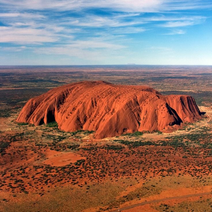
This sandstone monolith rises 1,140 feet (348 meters) above the central Australian plain and extends 2.2 miles (3.6 kilometers) in length. The formation displays distinct layers of arkosic sandstone that deposited approximately 550 million years ago. The rock changes color throughout the day and under different weather conditions, ranging from rust red to darker tones. Its surface features grooves, caves and depressions formed through erosion. This geological formation documents tectonic processes that tilted the sedimentary rock from horizontal layers into its current near vertical position.
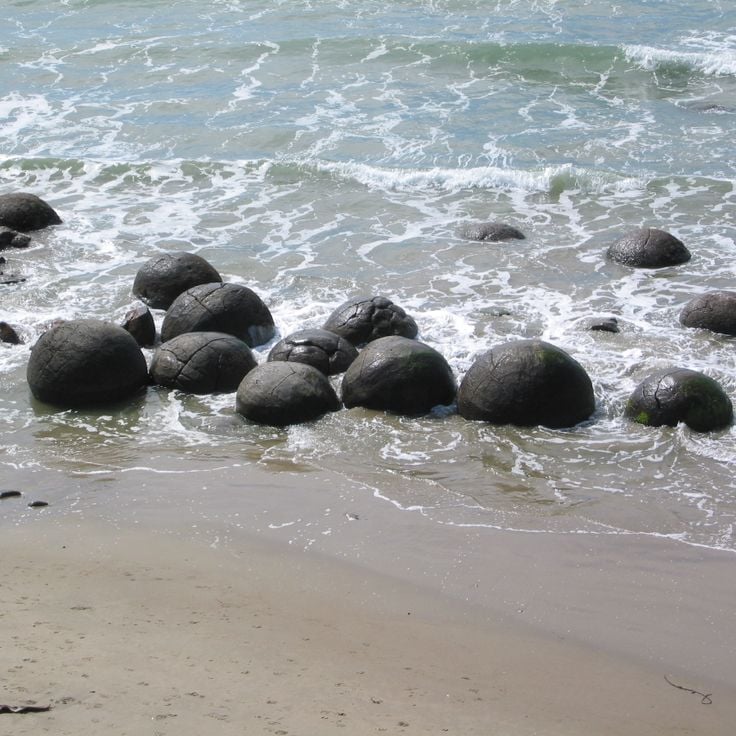
The Moeraki Boulders are spherical rock formations composed of hardened mud and limestone, reaching up to 6.5 feet (2 meters) in diameter. These geological structures formed through sedimentary deposits on the ocean floor approximately 60 million years ago and were exposed by coastal erosion in Otago. The Maori call them Eel-Pots and connect them to legends about stranded canoes.
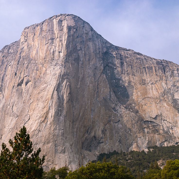
This vertical granite wall rises 3,000 feet (900 meters) above Yosemite Valley and stands as one of North America's most prominent rock formations. El Capitan formed roughly 100 million years ago through magmatic activity and was carved into its present shape by glacial movements during the last ice age. The wall features multiple climbing routes of varying difficulty and serves as a proving ground for extreme climbers testing their skills on one of the world's most demanding monoliths.
These granite boulders lie scattered across the Northern Territory desert, documenting millions of years of geological processes. The rounded stones formed through weathering and erosion, as softer surrounding rock gradually wore away. Some formations balance in seemingly precarious positions atop smaller rocks, while others rest individually on the red desert surface. The formations display various sizes ranging from roughly three feet to twenty feet (one to six meters) in diameter. The area extends several square miles along the Stuart Highway between Alice Springs and Tennant Creek.
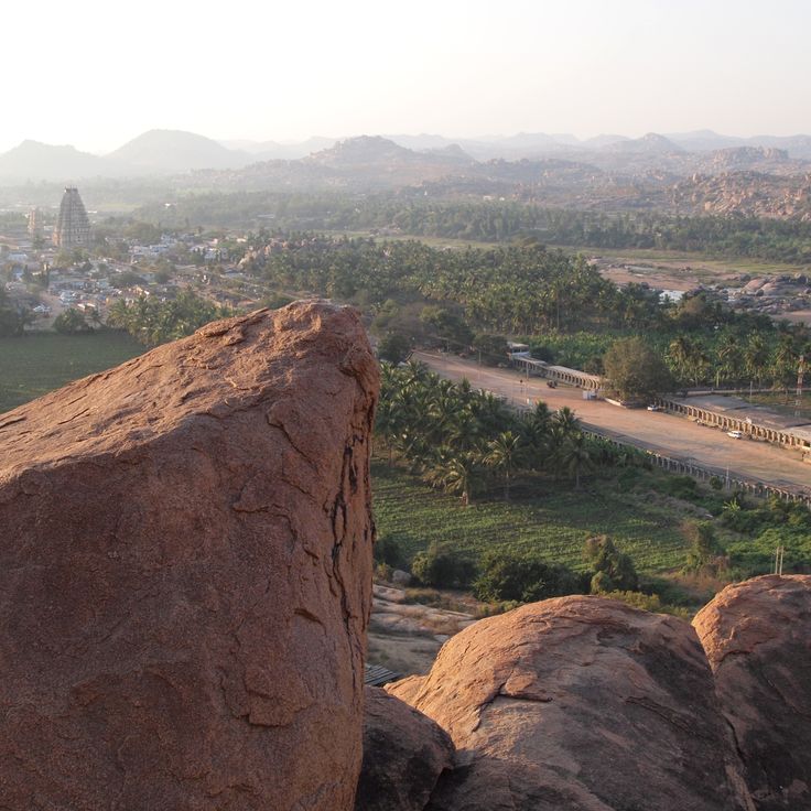
These granite formations document the geological history of the South Indian Deccan Plateau. The boulders formed through weathering of batholiths over millions of years. Erosion shaped the rounded contours and stacking patterns that now characterize the landscape of Hampi. The granite structures reach heights of several dozen feet and create natural balconies, caves and passages throughout the region.
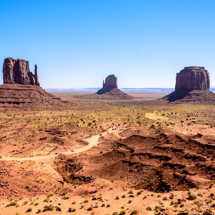
These red sandstone towers rise up to 1,000 feet (305 meters) from the Colorado Plateau floor and represent millions of years of geological processes. Monument Valley displays one of the most recognizable examples of natural erosion in North America, shaped by wind and water working through soft sandstone layers. The formations include distinctive mesas, buttes and spires that define this desert landscape within the Navajo Nation territory.
This sandstone massif extends five miles (eight kilometers) across western Australia and rises 2,821 feet (860 meters) above the surrounding plain. Mount Augustus stands as a prominent example of geological formations shaped by natural processes over millions of years. The mountain's granitic base is estimated to be around 1.7 billion years old, while the overlying sedimentary layer is considerably younger. The formation displays various erosion patterns and color variations that shift throughout the day as lighting conditions change.
This limestone formation rises 300 feet (91 meters) above the North Platte River valley in western Nebraska and documents geological processes that shaped the Great Plains region over millions of years. Chimney Rock served as a natural landmark for travelers on the Oregon Trail during the 19th century, appearing in more pioneer diaries and journals than almost any other site along the route. Erosion continues to reshape the slender spire, gradually altering its distinctive silhouette. The formation consists of layers of volcanic ash and clay deposited during the Oligocene epoch.
This granite monolith rises 633 meters (2,077 feet) from the desert plain and ranks among the world's largest freestanding rock formations. Ben Amera documents geological processes spanning millions of years, surrounded by sand dunes and smaller stone formations shaped by wind and erosion. The isolated location in Mauritania's interior makes access difficult but preserves the original character of this notable natural feature.
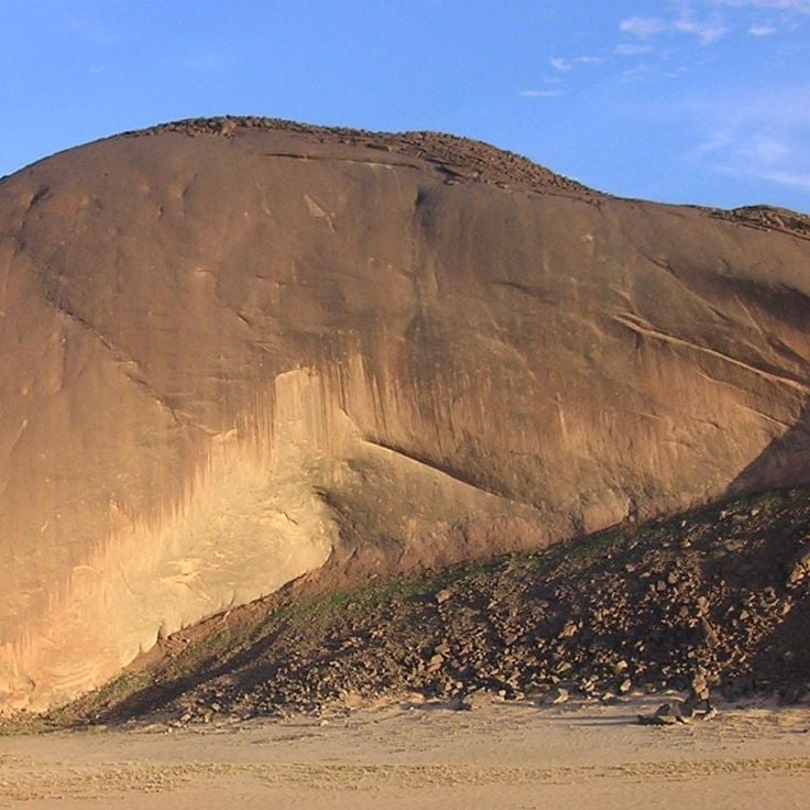
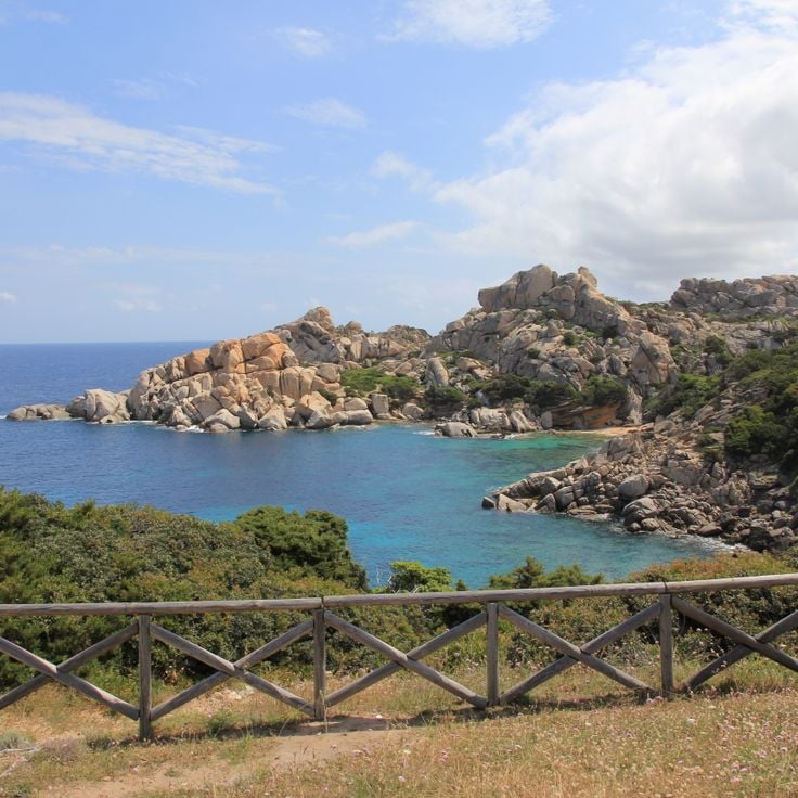
This granite formation on Sardinia's northern coast shows the results of millions of years of natural erosion. The rocks were shaped by wind and water that carved the stone into various forms. Capo Testa documents geological processes typical of Mediterranean coastal regions. The formation sits between the bays of Santa Reparata and Rena di Ponente, extending across a small peninsula.
This 250-ton (227-metric-ton) granite boulder has rested on a 45-degree inclined surface for more than 1200 years in Mahabalipuram, ranking among India's notable natural rock formations. Krishna's Butterball, named after a Hindu deity, demonstrates the geological forces that create such extraordinary natural phenomena over millions of years. The boulder defies gravity and remains in place, despite historical records documenting unsuccessful attempts to move it.
Hanging Rock is a volcanic formation from the Ordovician period with characteristic columns and projections rising 345 feet (105 meters) above the plain. This rock group formed through erosion processes that exposed harder rock layers while softer material eroded away. The formation documents volcanic activity that shaped this region of Australia approximately 450 million years ago and represents geological evidence created by natural processes over extended timeframes.
This round granite boulder measuring five meters (16 feet) in diameter has rested at 984 meters (3,228 feet) elevation between two rock faces in the Lysefjord since the last Ice Age, representing one of the most unusual geological formations in Scandinavia where the position of the stone documents glacial movements that occurred during the retreat of glaciers approximately 50,000 years ago, making Kjeragbolten a significant example of the natural processes that have shaped Norwegian fjord landscapes over millions of years.
This Millbrook sandstone block weighs 200 tons (180 metric tonnes) and balances on a base measuring only 12 inches (30 centimeters) across at Brimham Moor. The formation represents one of several geological structures created by natural erosion processes over millions of years, documenting this Yorkshire region's geological history through its unusual shape and weight distribution.
Pravčická Brána is a sandstone arch in the Bohemian Switzerland National Park with a span of 87 feet (26.5 meters), a height of 52 feet (16 meters), and a thickness of 26 feet (8 meters). This natural formation emerged through millions of years of erosion and stands as the largest sandstone arch in Europe within a forested rock landscape. The geological monument documents the region's history and attracts visitors from various countries.
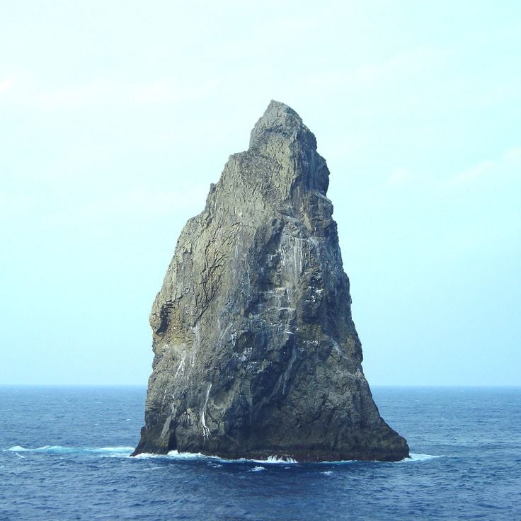
This natural stone pillar rises 165 feet (50 meters) from the sea off the coast of Saba and consists of volcanic rock. Lot's Wife formed through millions of years of erosion processes, as seawater and wind removed surrounding material and shaped this freestanding monolith. The formation documents the island's volcanic history and clearly displays the layering and texture of solidified magma. The rock shows characteristic fractures and weathering patterns typical of exposed volcanic formations in maritime environments.
This sandstone monolith rises 1,140 feet (348 meters) above the central Australian plain and extends 2.2 miles (3.6 kilometers) in length. The formation displays distinct layers of arkosic sandstone that deposited approximately 550 million years ago. The rock changes color throughout the day and under different weather conditions, ranging from rust red to darker tones. Its surface features grooves, caves and depressions formed through erosion. This geological formation documents tectonic processes that tilted the sedimentary rock from horizontal layers into its current near vertical position.
The Moeraki Boulders are spherical rock formations composed of hardened mud and limestone, reaching up to 6.5 feet (2 meters) in diameter. These geological structures formed through sedimentary deposits on the ocean floor approximately 60 million years ago and were exposed by coastal erosion in Otago. The Maori call them Eel-Pots and connect them to legends about stranded canoes.
This vertical granite wall rises 3,000 feet (900 meters) above Yosemite Valley and stands as one of North America's most prominent rock formations. El Capitan formed roughly 100 million years ago through magmatic activity and was carved into its present shape by glacial movements during the last ice age. The wall features multiple climbing routes of varying difficulty and serves as a proving ground for extreme climbers testing their skills on one of the world's most demanding monoliths.
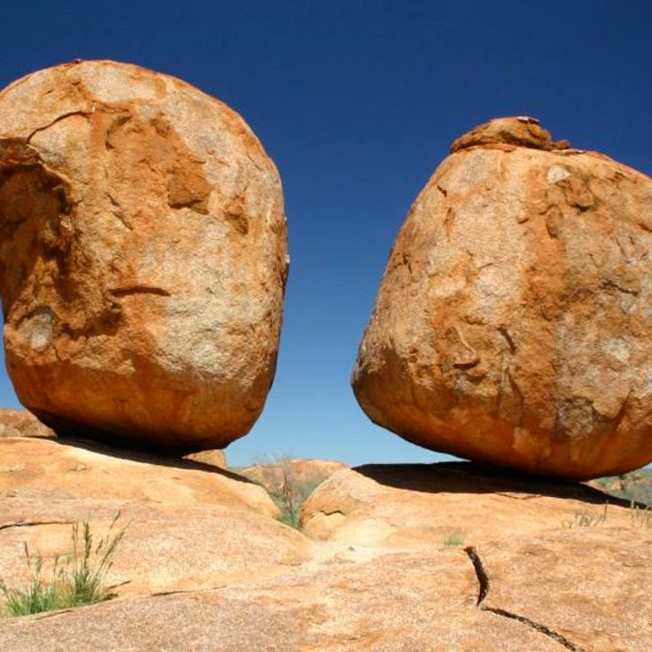
These granite boulders lie scattered across the Northern Territory desert, documenting millions of years of geological processes. The rounded stones formed through weathering and erosion, as softer surrounding rock gradually wore away. Some formations balance in seemingly precarious positions atop smaller rocks, while others rest individually on the red desert surface. The formations display various sizes ranging from roughly three feet to twenty feet (one to six meters) in diameter. The area extends several square miles along the Stuart Highway between Alice Springs and Tennant Creek.
These granite formations document the geological history of the South Indian Deccan Plateau. The boulders formed through weathering of batholiths over millions of years. Erosion shaped the rounded contours and stacking patterns that now characterize the landscape of Hampi. The granite structures reach heights of several dozen feet and create natural balconies, caves and passages throughout the region.
These red sandstone towers rise up to 1,000 feet (305 meters) from the Colorado Plateau floor and represent millions of years of geological processes. Monument Valley displays one of the most recognizable examples of natural erosion in North America, shaped by wind and water working through soft sandstone layers. The formations include distinctive mesas, buttes and spires that define this desert landscape within the Navajo Nation territory.
This sandstone massif extends five miles (eight kilometers) across western Australia and rises 2,821 feet (860 meters) above the surrounding plain. Mount Augustus stands as a prominent example of geological formations shaped by natural processes over millions of years. The mountain's granitic base is estimated to be around 1.7 billion years old, while the overlying sedimentary layer is considerably younger. The formation displays various erosion patterns and color variations that shift throughout the day as lighting conditions change.
This limestone formation rises 300 feet (91 meters) above the North Platte River valley in western Nebraska and documents geological processes that shaped the Great Plains region over millions of years. Chimney Rock served as a natural landmark for travelers on the Oregon Trail during the 19th century, appearing in more pioneer diaries and journals than almost any other site along the route. Erosion continues to reshape the slender spire, gradually altering its distinctive silhouette. The formation consists of layers of volcanic ash and clay deposited during the Oligocene epoch.
This granite monolith rises 633 meters (2,077 feet) from the desert plain and ranks among the world's largest freestanding rock formations. Ben Amera documents geological processes spanning millions of years, surrounded by sand dunes and smaller stone formations shaped by wind and erosion. The isolated location in Mauritania's interior makes access difficult but preserves the original character of this notable natural feature.
This granite formation on Sardinia's northern coast shows the results of millions of years of natural erosion. The rocks were shaped by wind and water that carved the stone into various forms. Capo Testa documents geological processes typical of Mediterranean coastal regions. The formation sits between the bays of Santa Reparata and Rena di Ponente, extending across a small peninsula.
This 250-ton (227-metric-ton) granite boulder has rested on a 45-degree inclined surface for more than 1200 years in Mahabalipuram, ranking among India's notable natural rock formations. Krishna's Butterball, named after a Hindu deity, demonstrates the geological forces that create such extraordinary natural phenomena over millions of years. The boulder defies gravity and remains in place, despite historical records documenting unsuccessful attempts to move it.
Hanging Rock is a volcanic formation from the Ordovician period with characteristic columns and projections rising 345 feet (105 meters) above the plain. This rock group formed through erosion processes that exposed harder rock layers while softer material eroded away. The formation documents volcanic activity that shaped this region of Australia approximately 450 million years ago and represents geological evidence created by natural processes over extended timeframes.
This round granite boulder measuring five meters (16 feet) in diameter has rested at 984 meters (3,228 feet) elevation between two rock faces in the Lysefjord since the last Ice Age, representing one of the most unusual geological formations in Scandinavia where the position of the stone documents glacial movements that occurred during the retreat of glaciers approximately 50,000 years ago, making Kjeragbolten a significant example of the natural processes that have shaped Norwegian fjord landscapes over millions of years.
This Millbrook sandstone block weighs 200 tons (180 metric tonnes) and balances on a base measuring only 12 inches (30 centimeters) across at Brimham Moor. The formation represents one of several geological structures created by natural erosion processes over millions of years, documenting this Yorkshire region's geological history through its unusual shape and weight distribution.
Pravčická Brána is a sandstone arch in the Bohemian Switzerland National Park with a span of 87 feet (26.5 meters), a height of 52 feet (16 meters), and a thickness of 26 feet (8 meters). This natural formation emerged through millions of years of erosion and stands as the largest sandstone arch in Europe within a forested rock landscape. The geological monument documents the region's history and attracts visitors from various countries.
This natural stone pillar rises 165 feet (50 meters) from the sea off the coast of Saba and consists of volcanic rock. Lot's Wife formed through millions of years of erosion processes, as seawater and wind removed surrounding material and shaped this freestanding monolith. The formation documents the island's volcanic history and clearly displays the layering and texture of solidified magma. The rock shows characteristic fractures and weathering patterns typical of exposed volcanic formations in maritime environments.
This sandstone monolith rises 1,140 feet (348 meters) above the central Australian plain and extends 2.2 miles (3.6 kilometers) in length. The formation displays distinct layers of arkosic sandstone that deposited approximately 550 million years ago. The rock changes color throughout the day and under different weather conditions, ranging from rust red to darker tones. Its surface features grooves, caves and depressions formed through erosion. This geological formation documents tectonic processes that tilted the sedimentary rock from horizontal layers into its current near vertical position.
The Moeraki Boulders are spherical rock formations composed of hardened mud and limestone, reaching up to 6.5 feet (2 meters) in diameter. These geological structures formed through sedimentary deposits on the ocean floor approximately 60 million years ago and were exposed by coastal erosion in Otago. The Maori call them Eel-Pots and connect them to legends about stranded canoes.
This vertical granite wall rises 3,000 feet (900 meters) above Yosemite Valley and stands as one of North America's most prominent rock formations. El Capitan formed roughly 100 million years ago through magmatic activity and was carved into its present shape by glacial movements during the last ice age. The wall features multiple climbing routes of varying difficulty and serves as a proving ground for extreme climbers testing their skills on one of the world's most demanding monoliths.
These granite boulders lie scattered across the Northern Territory desert, documenting millions of years of geological processes. The rounded stones formed through weathering and erosion, as softer surrounding rock gradually wore away. Some formations balance in seemingly precarious positions atop smaller rocks, while others rest individually on the red desert surface. The formations display various sizes ranging from roughly three feet to twenty feet (one to six meters) in diameter. The area extends several square miles along the Stuart Highway between Alice Springs and Tennant Creek.
These granite formations document the geological history of the South Indian Deccan Plateau. The boulders formed through weathering of batholiths over millions of years. Erosion shaped the rounded contours and stacking patterns that now characterize the landscape of Hampi. The granite structures reach heights of several dozen feet and create natural balconies, caves and passages throughout the region.
These red sandstone towers rise up to 1,000 feet (305 meters) from the Colorado Plateau floor and represent millions of years of geological processes. Monument Valley displays one of the most recognizable examples of natural erosion in North America, shaped by wind and water working through soft sandstone layers. The formations include distinctive mesas, buttes and spires that define this desert landscape within the Navajo Nation territory.
This sandstone massif extends five miles (eight kilometers) across western Australia and rises 2,821 feet (860 meters) above the surrounding plain. Mount Augustus stands as a prominent example of geological formations shaped by natural processes over millions of years. The mountain's granitic base is estimated to be around 1.7 billion years old, while the overlying sedimentary layer is considerably younger. The formation displays various erosion patterns and color variations that shift throughout the day as lighting conditions change.
This limestone formation rises 300 feet (91 meters) above the North Platte River valley in western Nebraska and documents geological processes that shaped the Great Plains region over millions of years. Chimney Rock served as a natural landmark for travelers on the Oregon Trail during the 19th century, appearing in more pioneer diaries and journals than almost any other site along the route. Erosion continues to reshape the slender spire, gradually altering its distinctive silhouette. The formation consists of layers of volcanic ash and clay deposited during the Oligocene epoch.
This granite monolith rises 633 meters (2,077 feet) from the desert plain and ranks among the world's largest freestanding rock formations. Ben Amera documents geological processes spanning millions of years, surrounded by sand dunes and smaller stone formations shaped by wind and erosion. The isolated location in Mauritania's interior makes access difficult but preserves the original character of this notable natural feature.
This granite formation on Sardinia's northern coast shows the results of millions of years of natural erosion. The rocks were shaped by wind and water that carved the stone into various forms. Capo Testa documents geological processes typical of Mediterranean coastal regions. The formation sits between the bays of Santa Reparata and Rena di Ponente, extending across a small peninsula.
This 250-ton (227-metric-ton) granite boulder has rested on a 45-degree inclined surface for more than 1200 years in Mahabalipuram, ranking among India's notable natural rock formations. Krishna's Butterball, named after a Hindu deity, demonstrates the geological forces that create such extraordinary natural phenomena over millions of years. The boulder defies gravity and remains in place, despite historical records documenting unsuccessful attempts to move it.