See the monuments around you in AROpen chests in the app
Around Us is built for your phone — point your camera at the streets and discover the monuments and places around you in augmented reality.Around Us is built for your phone — chests unlock when you walk, explore and capture nearby places.
From the highest peaks to coastal cliffs, this collection brings together geographically significant observation points across all continents. The locations offer views of mountain ranges, waterfalls, deserts, oceans, and notable architectural structures.
The selection includes the Great Wall near Beijing, the Cliffs of Moher above the Atlantic, the Grand Canyon in Arizona, and Mount Everest on the Nepal-Tibet border. Among the waterfalls are Iguazú Falls between Brazil and Argentina, Victoria Falls between Zambia and Zimbabwe, and Niagara Falls between Canada and the United States. The Pyramids of Giza, the Alhambra in Granada, and the Taj Mahal in Agra showcase important architectural achievements from different eras.
Natural formations such as Uluru in the Australian outback, Halong Bay in Vietnam, Banff National Park in the Canadian Rockies, and the Norwegian fjords demonstrate Earth's geological diversity. Additional locations include Santorini in the Aegean Sea, the Amazon rainforest, Horseshoe Bend on the Colorado River, Petra in Jordan, Mount Kilimanjaro in Tanzania, the Fitz Roy range in Patagonia, and Plitvice Lakes National Park in Croatia.
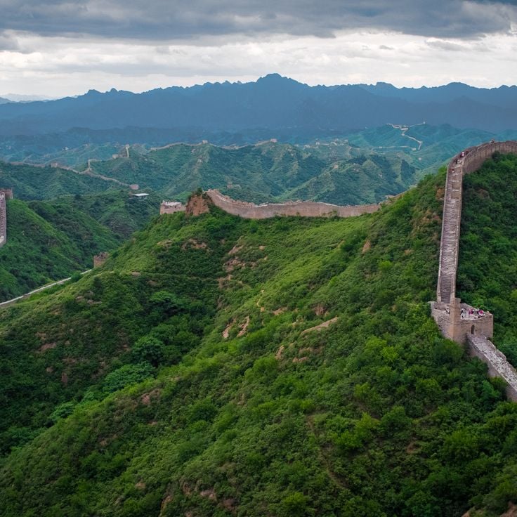
The Great Wall extends over 13000 miles (21000 kilometers) across China and was built between the 7th century BCE and the 16th century. This fortification runs through mountains, plains, and deserts, providing numerous observation points overlooking the surrounding landscapes. From various sections, visitors can observe the wall's winding structure as it stretches across mountain ridges and valleys, offering views into the historical defense system.
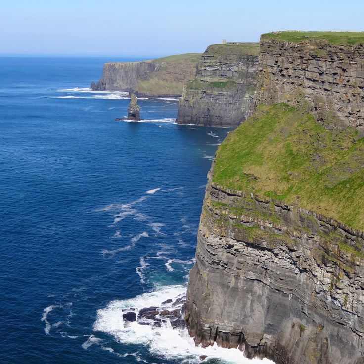
The Cliffs of Moher rise 700 feet (214 meters) above the Atlantic Ocean and extend for 9 miles (14 kilometers) along Ireland's western coast. These limestone cliffs offer wide views of the ocean, the Aran Islands, and Galway Bay. The viewpoint is located in County Clare and provides observation of the geological formations from the Carboniferous period, formed approximately 320 million years ago. The cliffs host numerous seabird colonies and are part of the Burren and Cliffs of Moher UNESCO Geopark.
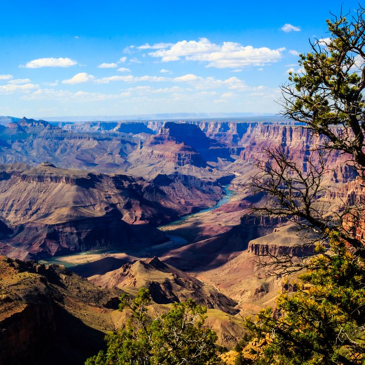
The Colorado River has carved this 277-mile (446-kilometer) canyon through rock over millions of years. The Grand Canyon extends across northern Arizona and reaches depths of up to 6,000 feet (1,829 meters) in places. The different rock layers exposed along the canyon walls document nearly two billion years of geological history. Multiple viewpoints along the South Rim and North Rim provide direct views into the gorge and of the river below.
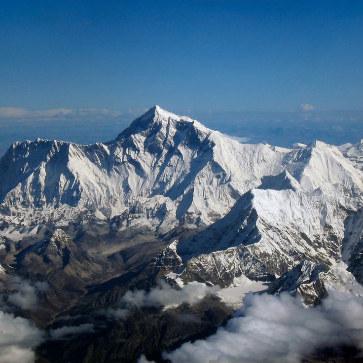
Mount Everest reaches an elevation of 29,029 feet (8,848 meters) above sea level and marks the border between Nepal and Tibet. This mountain forms the highest point on Earth and lies within the Himalayan range. From various observation points in the region, the summit and surrounding mountain chains can be viewed. The mountain attracts climbers and visitors who seek to experience the high-altitude landscape.
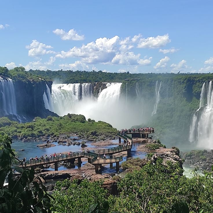
The Iguazú Falls mark the border between Brazil and Argentina where the Iguazú River plunges over a basalt cliff. The system consists of 275 individual waterfalls extending across a width of roughly 1.7 miles (2.7 kilometers). The tallest waterfall, known as the Devil's Throat, reaches a height of 269 feet (82 meters). The falls sit within two national parks, both designated as UNESCO World Heritage sites. From the Brazilian side, frontal views encompass the entire waterfall chain and the surrounding subtropical rainforest. The permanent water mist generates numerous rainbows under appropriate light conditions.
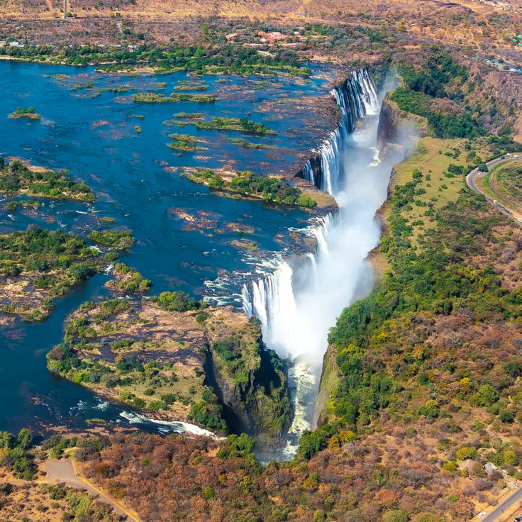
Victoria Falls marks the point where the Zambezi River drops approximately 355 feet (108 meters) across a width of roughly 5,600 feet (1.7 kilometers) into a narrow gorge. Located on the border between Zambia and Zimbabwe, these falls rank among the largest waterfalls in the world and generate a continuous spray cloud visible from considerable distances. Several viewpoints along the gorge provide direct sightlines to the falling water and the surrounding river landscape.
The Pyramids of Giza are three monumental pharaonic tombs from the Old Kingdom, built approximately 4,500 years ago. These archaeological structures on the outskirts of Cairo represent some of the oldest surviving constructions made by humanity. The complex includes the Great Pyramid of Khufu, the Pyramid of Khafre, and the Pyramid of Menkaure, accompanied by the Sphinx and several smaller satellite pyramids. From various vantage points, the pyramids provide views across the desert landscape and the nearby urban area.
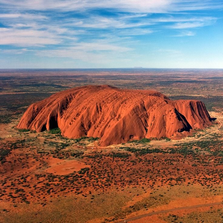
Uluru rises 1,142 feet (348 meters) above the surrounding desert plain in the heart of the Northern Territory and measures 5.8 miles (9.4 kilometers) in circumference. This sandstone monolith changes color with the sunlight and holds cultural importance for the Anangu people. The rock formation developed approximately 550 million years ago and displays traces of caves, watercourses, and traditional rock paintings. Several viewing points around the base provide observations of this geological feature set within the desert landscape of central Australia.
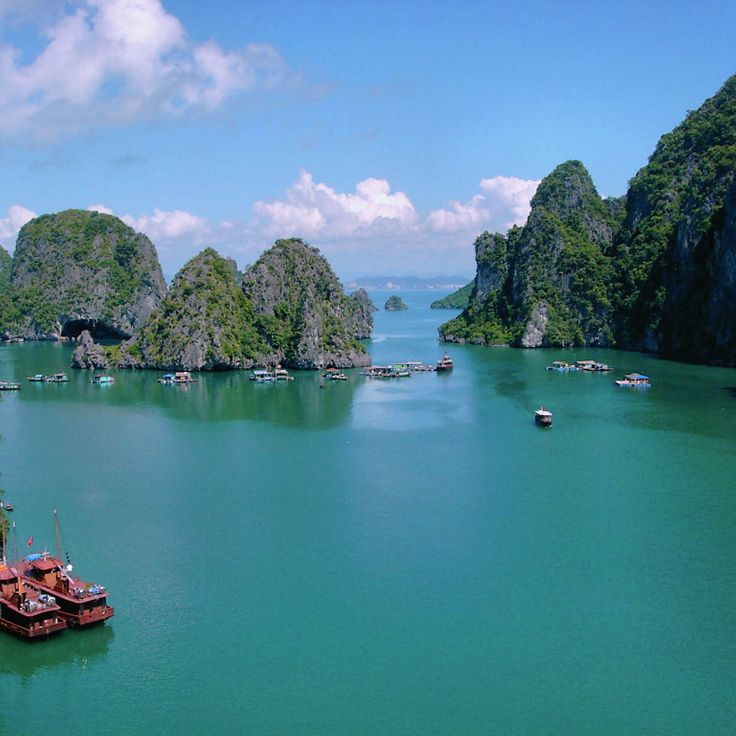
Ha Long Bay spans roughly 600 square miles and contains over 1,600 limestone islands and rock formations rising from the green waters. This marine bay sits in the Gulf of Tonkin, and its limestone formations developed over millions of years through geological processes. The bay provides vantage points from boats, kayak tours, and elevated islands, from which visitors can observe the numerous islands, hidden caves, and turquoise waters. The formations range from a few feet to nearly 650 feet in height.
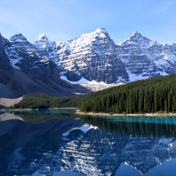
Banff National Park spans 2564 square miles (6641 square kilometers) and includes glaciers, ice fields, coniferous forests, and alpine terrain in the Canadian Rockies. Viewpoints throughout the park provide sights of turquoise glacial lakes, including Lake Louise and Moraine Lake, along with peaks reaching over 10000 feet (3000 meters). Mountain roads and trails lead to observation points overlooking the Bow Range, Waputik Mountains, and Bow Valley. Winter transforms the mountain slopes into ski areas, while summer months open access to higher elevation passes and ridges.
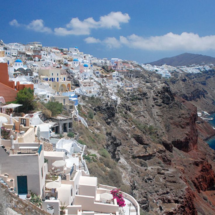
Santorini is a volcanic island in the Aegean Sea, known for its white buildings with blue domes perched on steep cliffs above the water. The caldera was formed by a volcanic eruption approximately 3,600 years ago and now creates a semicircular bay reaching depths of up to 1,300 feet (400 meters). The villages of Oia, Fira, and Imerovigli line the crater rim and provide observation points overlooking the surrounding islands of Thirasia and Nea Kameni. The cliffs display multicolored rock layers of volcanic material that document the island's geological history.
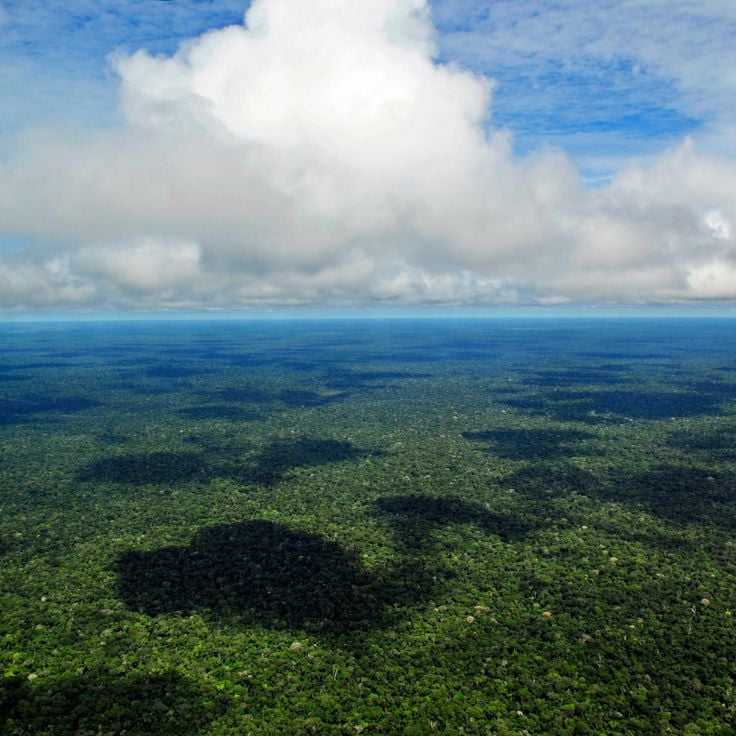
This rainforest spans 2.1 million square miles (5.5 million square kilometers) and contains over 40,000 plant species and 1,300 bird species. The observation points provide views of the dense canopy extending to the horizon and reveal the layered vegetation levels. Rivers wind through the greenery, forming waterways visible from elevated vantage points. These viewing locations convey the geographic scale of this forested area.
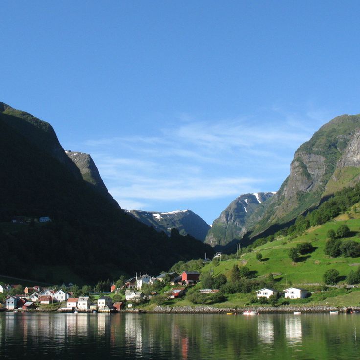
The Norwegian fjords extend over a hundred miles inland and are flanked by steep rock walls that rise several hundred feet from the water. These deep sea inlets were carved by glacial erosion during the Ice Age and form one of the most distinct geological features of Norway's western coast. The region encompasses numerous branching waterways, including Geirangerfjord and Storfjord, which cut through the mountainous landscape and provide access to remote valleys and settlements.
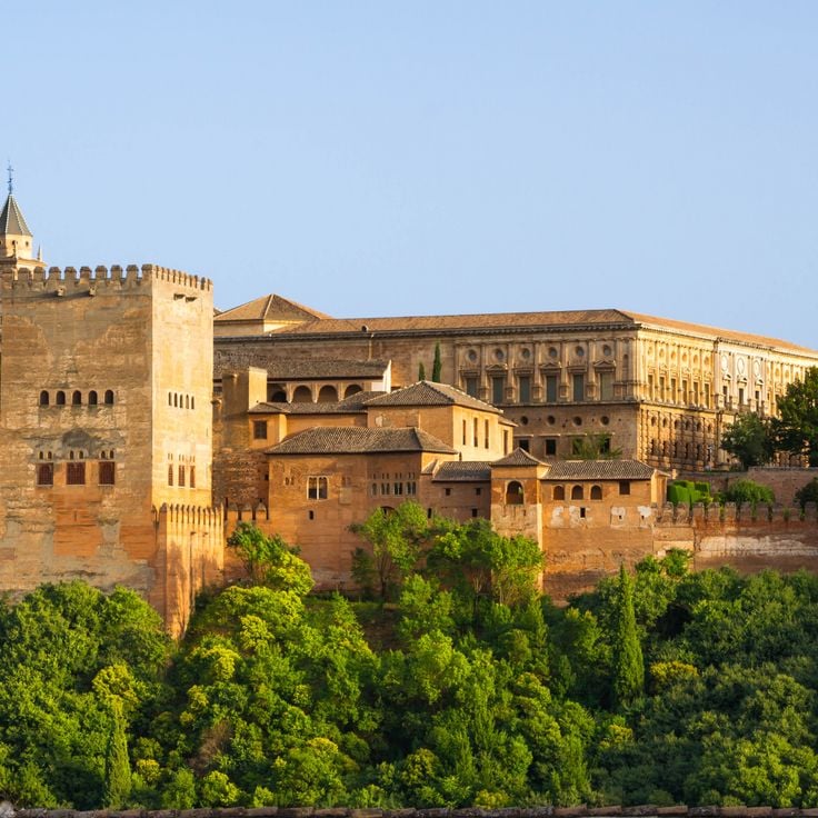
The Alhambra is a Moorish palace from the 13th century located on a hill above Granada. The complex displays Islamic architecture with decorated arches, geometric patterns, and ceramic tiles throughout its courtyards and halls. From the fortification walls and towers, the Alhambra provides views over the city of Granada, the Sierra Nevada, and the surrounding Andalusian plains. The Generalife gardens extend across the adjacent slopes and complement the palace architecture.
The Taj Mahal is a white marble mausoleum built in the 17th century that combines Persian, Ottoman, and Indian architectural styles. This monumental structure rises on the banks of the Yamuna River and was commissioned by Mughal Emperor Shah Jahan to commemorate his deceased wife Mumtaz Mahal. The structure includes a central domed chamber, four minarets at the corners, and extensive Mughal-style gardens. The facades feature inlay work with semiprecious stones and calligraphic inscriptions. The mausoleum serves as a significant example of Mughal architecture.
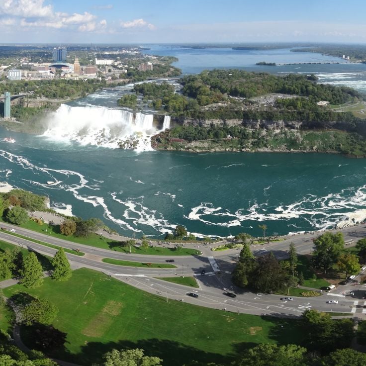
The Niagara Falls comprise three waterfalls that flow across cliffs at the border between Canada and the United States. Water passes over the falls at a rate of approximately 85,000 cubic feet per second (2,400 cubic meters per second). Observation points on the Canadian side provide views of the Horseshoe Falls, American Falls, and Bridal Veil Falls. The cliffs formed through erosion of the Niagara Escarpment, a geological feature extending across the region. Visitors can observe the water flow from various perspectives, including platforms along the gorge and elevated locations overlooking the entire formation.
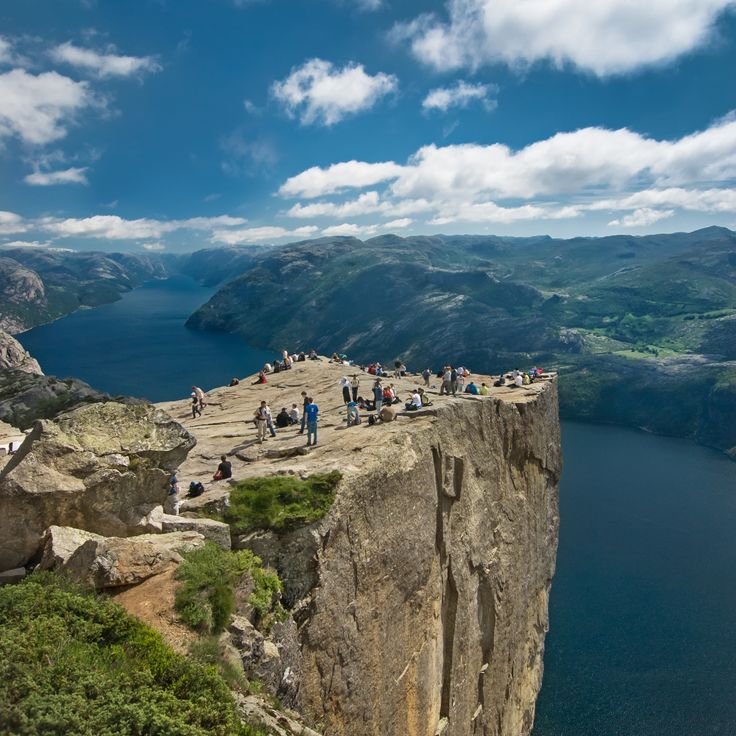
Preikestolen rises 1,982 feet (604 meters) above the Lysefjord and forms a rock platform roughly 82 feet (25 meters) wide. This formation provides views over the Norwegian fjord system and the surrounding mountains of the Rogaland region. The flat surface of the rock ledge ends at a nearly vertical edge that drops directly above the fjord waters. Access follows a hiking trail that crosses through the mountainous landscape of southwestern Norway and traverses different elevations.
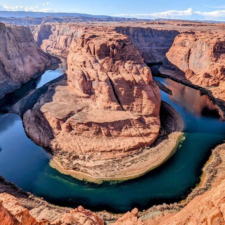
Horseshoe Bend displays a 270-degree turn of the Colorado River, which has carved 300 meters (984 feet) down into the red sandstone. This geological formation lies within Glen Canyon and is visible from the rim of a cliff that provides a direct view of the horseshoe-shaped river loop. The viewpoint sits near Page and allows visitors to observe the erosive forces that have shaped this landscape over millions of years. The Navajo Sandstone walls surround the river and form a natural amphitheater in the Arizona desert terrain.
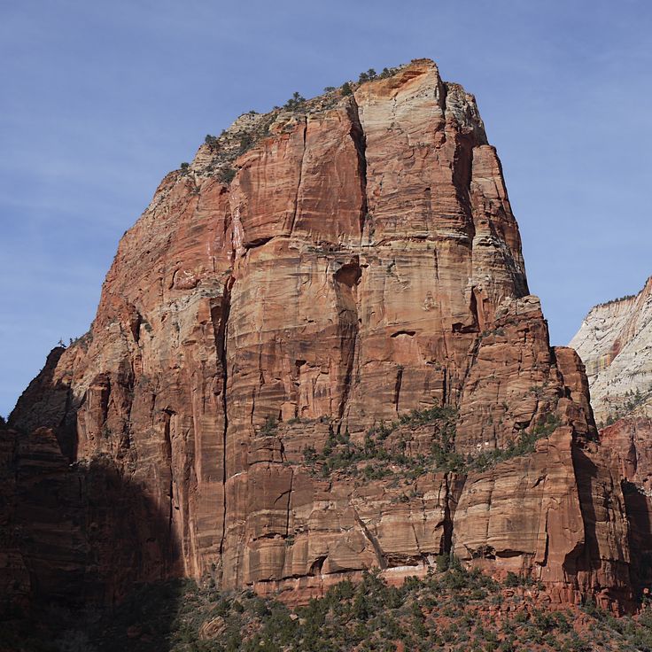
Angels Landing is a 453-foot (138-meter) rock formation rising above the valley in Zion National Park. This viewpoint is reached via a hiking trail that includes narrow paths with anchored safety chains, guiding hikers to the summit. From this position, views extend across Zion Canyon, the surrounding sandstone cliffs, and the Virgin River valley below. The formation provides a geographically significant vantage point for observing the geological structures of the Colorado Plateau.
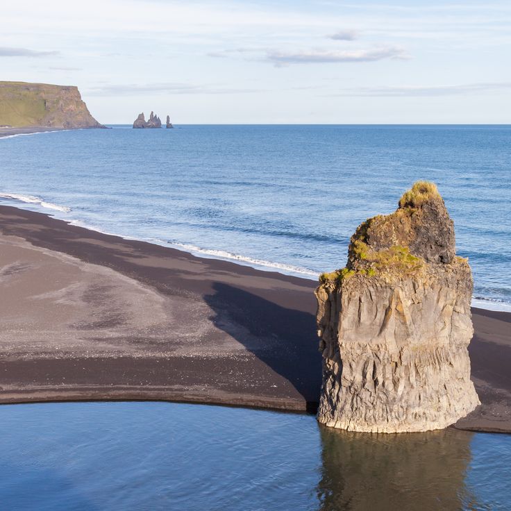
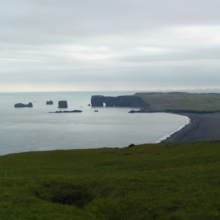
This volcanic black sand beach lies on Iceland's southern coast near Vík í Mýrdal, one of the wettest villages in the country. The dark basalt grains come from cooled lava of past eruptions, ground into fine sand by the Atlantic Ocean. From the beach, visitors see the Reynisdrangar sea stacks offshore, which local folklore describes as trolls turned to stone. The shoreline is flanked by Hálsanefshellir, a basalt column cave formed by erosion. The area experiences strong winds and unpredictable waves, requiring visitors to maintain distance from the surf.
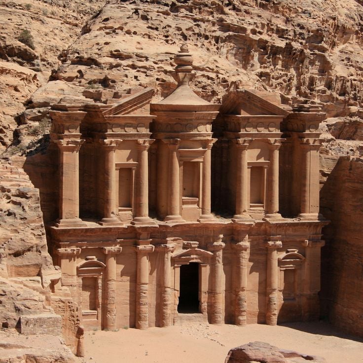
This ancient city in Jordan contains over 800 monuments carved into red sandstone cliffs, including tombs, temples, and altars. Petra offers numerous vantage points from which visitors can observe the monumental architecture and surrounding desert landscape. The rock faces, which extend throughout the site, provide panoramic views of the Nabataean structures and the rugged canyons of the region.
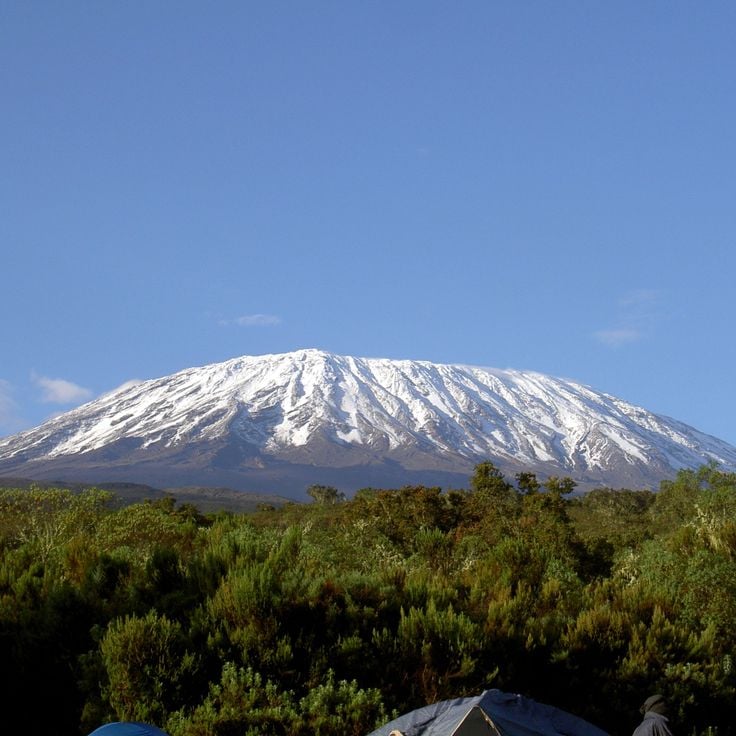
Mount Kilimanjaro is a 19,341-foot (5,895-meter) volcano with three extinct volcanic cones that rises amid a savanna landscape. The mountain provides viewpoints along its ascent routes where visitors can observe the surrounding plains, mountain forests, and glacial formations at the summit. The mountain's different elevation zones display varying vegetation types and geological features.
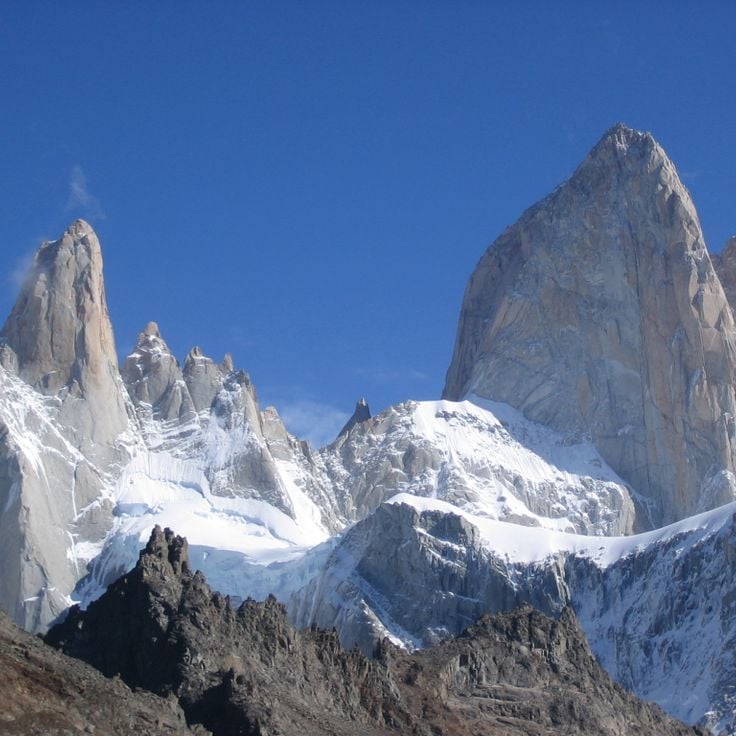
The granite peaks of the Fitz Roy mountain range rise to 11,171 feet (3,405 meters) and form a distinctive formation in Los Glaciares National Park. The massif lies in the Patagonian Andes and extends along the border between Argentina and Chile. The steep rock walls and glaciers attract climbers and hikers from various regions. The surrounding valleys provide access to several observation points from which the jagged peaks and surrounding mountain landscape become visible.
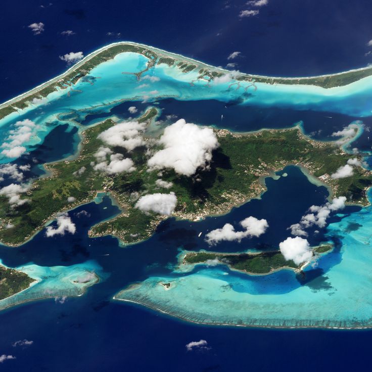
This volcanic island in the South Pacific rises around Mount Otemanu, which reaches over 2300 feet (700 meters) above the surrounding water. The atoll is encircled by a lagoon separated from the open ocean by a coral reef. The island is part of the Society Islands archipelago and provides viewing points of the central mountain's steep slopes, the turquoise waters of the lagoon, and the small islands scattered along the outer reef. From several locations, visitors can observe the mountain's distinctive double-peak formation and the contrasts between the dark volcanic rock and the light coral sand.
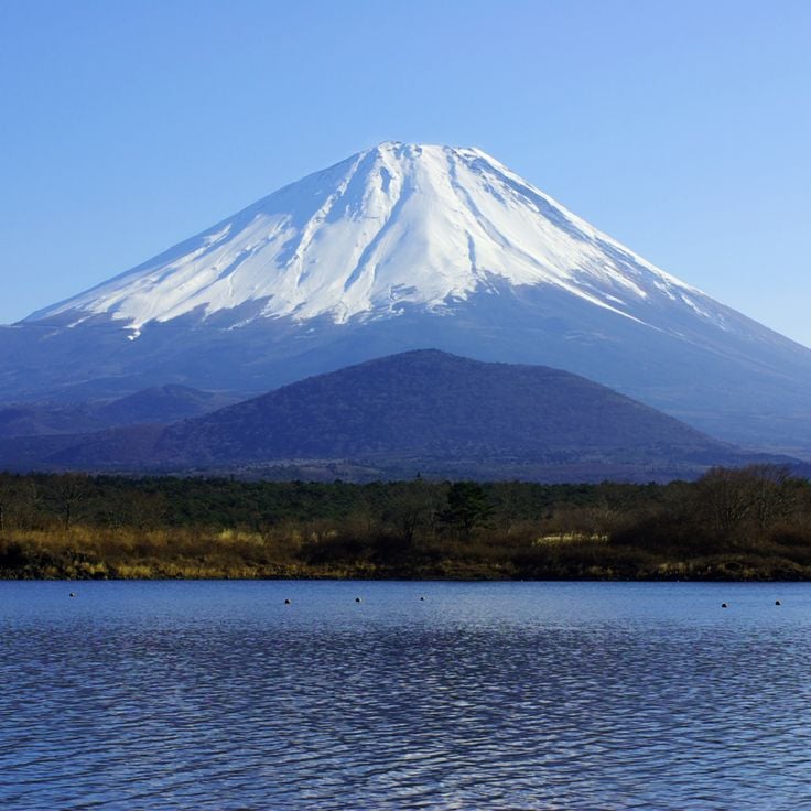
Mount Fuji is the tallest mountain in Japan, reaching an elevation of 12,388 feet (3776 meters) above sea level. This volcanic peak dominates the landscape of Honshu Island and offers expansive views from its summit across the surrounding plains, forests, and on clear days toward Tokyo. At the top, a crater measuring approximately 1640 feet (500 meters) in diameter marks the mountain's volcanic origin. The mountain serves as an important observation point from which visitors can survey the geographic formations of the region and the expanse of the Japanese countryside.
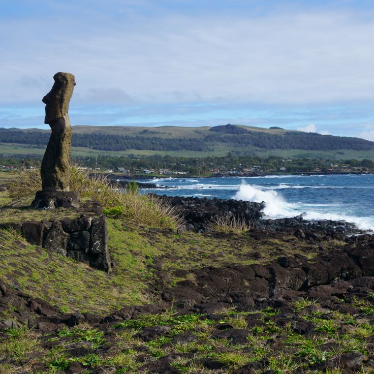
Easter Island contains 887 recorded monumental stone figures created between 1250 and 1500. These statues, known as moai, stand along the coastline and inland areas, providing views across the South Pacific. The island is located 2237 miles (3600 kilometers) west of the Chilean coast and allows observation of the volcanic landscape with three extinct volcanoes. The stone platforms where the moai were erected are positioned at elevated points overlooking the ocean and surrounding terrain.
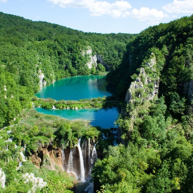
Plitvice Lakes National Park consists of 16 lakes at different elevations, connected by 92 waterfalls flowing over limestone formations. The water system extends across a forested area and forms natural travertine barriers that separate the lakes from one another. The lakes range from 1476 feet (450 meters) to 2067 feet (630 meters) above sea level. Visitors can explore the area on wooden walkways and hiking trails to observe the various waterfalls and surrounding vegetation.
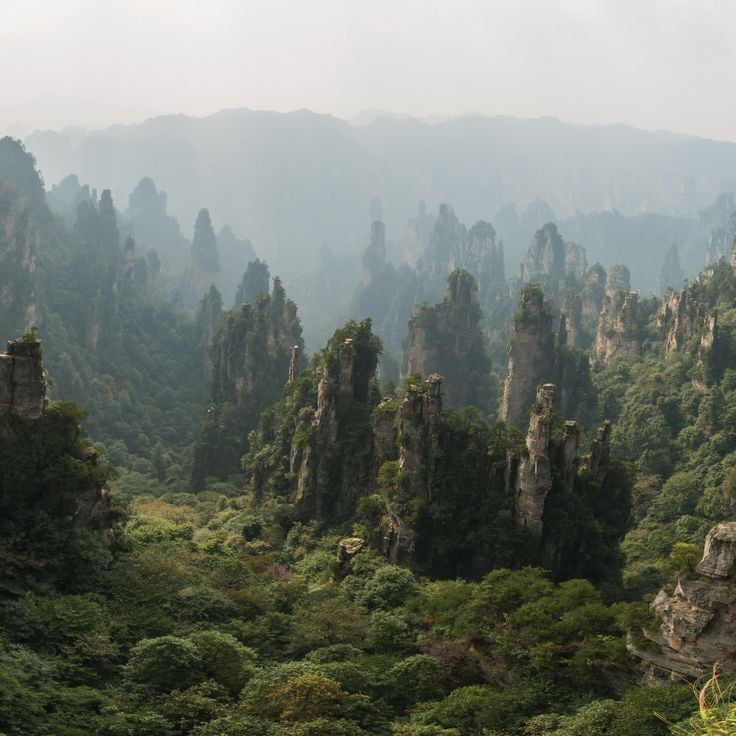
Zhangjiajie National Forest Park is located in Hunan Province and contains over 3000 quartzite sandstone pillars, many of which exceed heights of 200 meters (656 feet). These geological formations rise from dense forest and create a landscape of gorges, natural bridges, and waterfalls. The area was designated as China's first national forest reserve and forms part of the larger Wulingyuan scenic area. Visitors can observe the formations from various viewpoints along hiking trails and through a glass elevator system that provides access to elevated platforms.
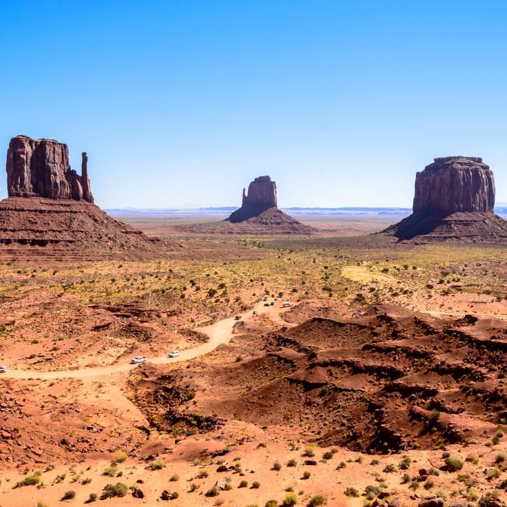
Monument Valley extends across the Colorado Plateau and presents distinct red sandstone formations that rise up to 1,000 feet (300 meters) above the desert floor. These geological structures have been shaped by erosion over millions of years and form isolated mesas, buttes, and spires. The valley lies within the Navajo Nation and provides viewpoints of the characteristic formations that stand against the desert sky and allow extensive sightlines across the surrounding landscape.
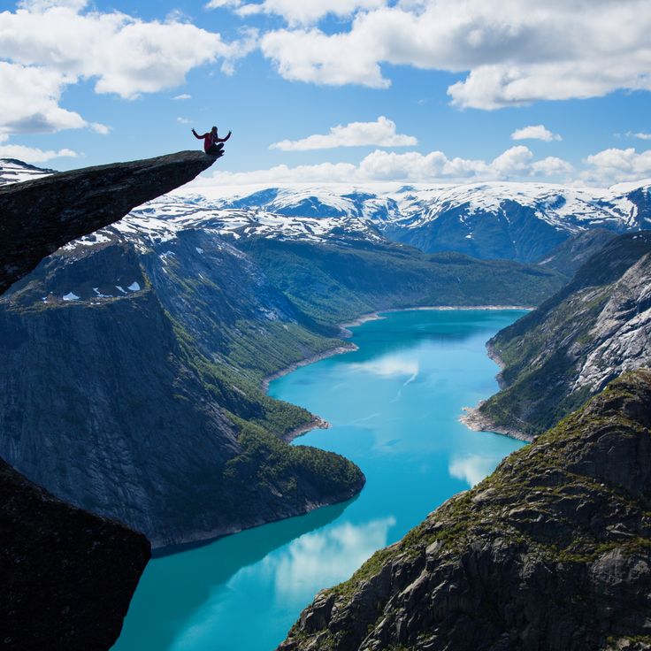
This rock formation extends horizontally about 2,300 feet (700 meters) above Lake Ringedalsvatnet in Ullensvang, providing views across the fjord-marked landscape of the Hardangervidda region. Reaching Trolltunga requires a hike of roughly 12 to 14 miles (20 to 22 kilometers) round trip through varied terrain with an elevation gain of approximately 3,000 feet (900 meters).
Dyrhólaey is a prominent rock formation on Iceland's southern coast that rises approximately 400 feet (120 meters) above the Atlantic and forms a natural arch large enough for small boats to pass through in calm conditions. From this observation point, views extend across the black sand beaches of Reynisfjara to the east and the Mýrdalsjökull glacier to the north. The cliffs serve as nesting grounds for puffins, which are present in large numbers between May and August. This cape marks the southernmost point of Iceland's mainland and offers views of waves breaking against the volcanic basalt columns along the shore.
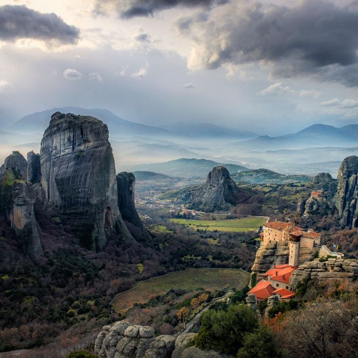
The Meteora monasteries stand on sandstone pillars that rise up to 1,300 feet (400 meters) above the Thessaly plain. This complex consists of six active Orthodox monasteries built between the 14th and 16th centuries atop natural rock towers. The monastery terraces provide views across the Pinios River valley and surrounding mountain formations.
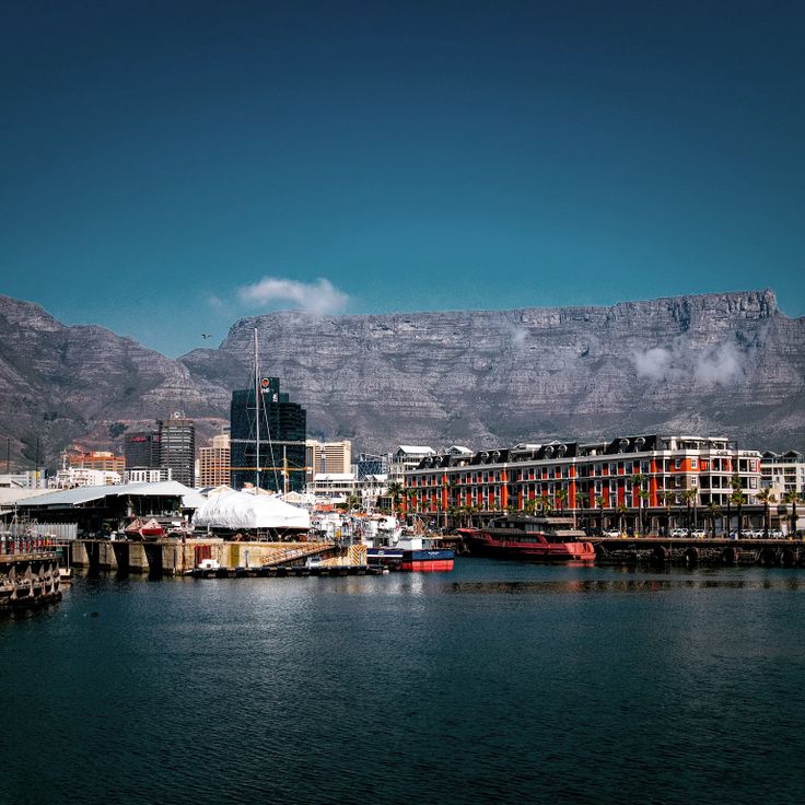
This flat topped mountain rises more than 3,280 feet (1,000 meters) above Cape Town and the Atlantic Ocean. The summit plateau extends over 1.9 miles (3 kilometers) in length and provides views across the city, Robben Island, the Cape Peninsula and the South African interior. Visitors reach the summit by rotating cable car or via several hiking trails through fynbos vegetation.
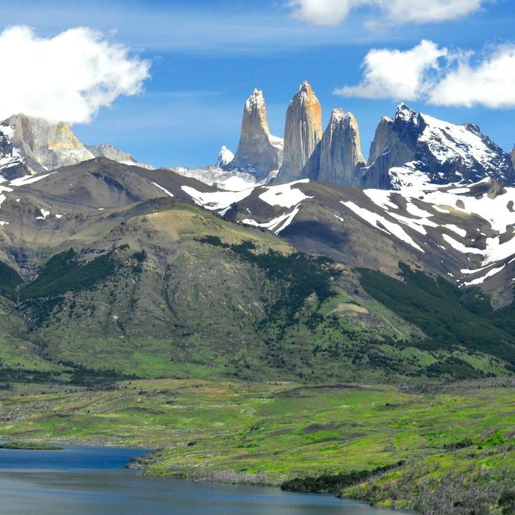
Torres del Paine is a 935 square mile (2,420 square kilometer) national park in southern Chile between the Strait of Magellan and the Argentine border. Established in 1959, this park forms a high mountain landscape with three distinct granite towers rising roughly 8,200 feet (2,500 meters) above the Patagonian steppe. The terrain comprises glacial fields, several lakes, extensive glaciers and river valleys shaped by ice flows from the Southern Patagonian Ice Field. Visitors reach the park via Puerto Natales, approximately 70 miles (112 kilometers) south of the main entrance.
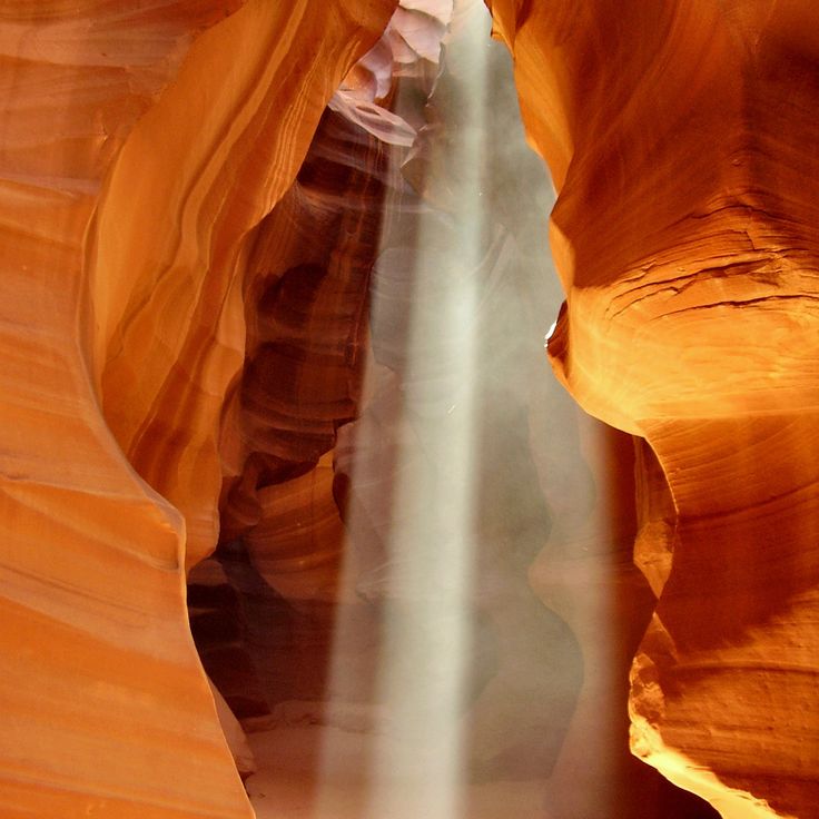
This slot canyon near Page in Arizona displays sandstone formations carved by water erosion over thousands of years. The passages range from a few inches to several feet in width, and openings in the ceiling allow daylight to illuminate the undulating walls. The canyon is divided into two sections: Upper Antelope Canyon and Lower Antelope Canyon, both located on Navajo land. Visitors can observe the geological structures and light effects that vary depending on time of day and season. Access is exclusively through guided tours.
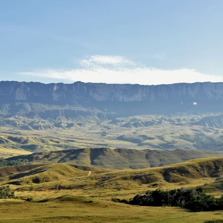
This table mountain on the border of Brazil, Venezuela and Guyana rises to 9,219 feet (2,810 meters) above sea level and stands among the oldest geological formations on Earth. Mount Roraima offers views across the Guiana Highlands, where tropical rainforest meets sheer sandstone cliffs. The flat summit plateau extends roughly 12 square miles (31 square kilometers) and features weathered rock formations, endemic plant species and waterfalls cascading from the edges. The multi-day trek to the summit passes through several vegetation zones and provides views of neighboring tepuis and the Venezuelan Gran Sabana.
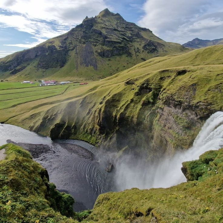
This viewpoint at Skógafoss provides access to a 200-foot waterfall in southern Iceland, where the Skógá River drops over former sea cliffs. The location offers close-range views from the base and an elevated platform reached by stairway, with sight lines extending across the coastal plain toward the Atlantic Ocean.
This overlook in Grand Teton National Park sits at the northern end of the Teton Range and provides open views across the Willow Flats wetlands and the Snake River. The Teton Range rises behind the floodplain, with the Grand Teton reaching 13,775 feet (4,199 meters). The area serves as habitat for moose, bison and waterfowl, particularly during morning and evening hours. Access is via US Highway 89/191/287 between Jackson Lake and Moran Junction. Parking is available, and the viewpoint is directly accessible from the road.
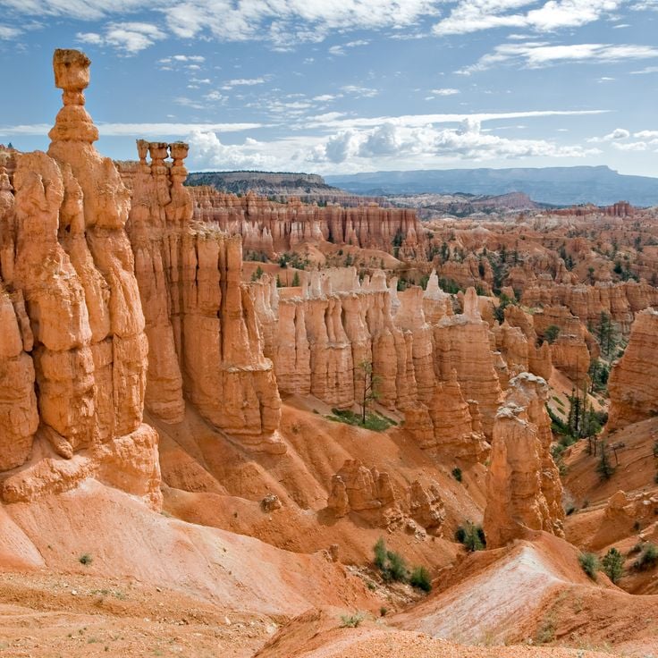
Bryce Canyon National Park presents a remarkable assembly of rock spires and amphitheaters in southern Utah. These geological formations developed through erosion processes over millions of years, creating a landscape of orange, red, and white limestone columns. The protected area spans more than 56 square miles (145 square kilometers) and offers several viewpoints along the edge of the Paunsaugunt Plateau at elevations between 8,000 and 9,100 feet (2,400 to 2,800 meters).
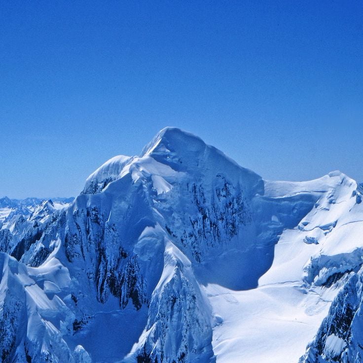
This 12,218-foot peak is New Zealand's highest mountain and dominates the Southern Alps. Aoraki / Mount Cook sits within a national park shaped by glaciers, icefields and alpine ridges. The view from the summit and surrounding observation points reveals glaciated slopes, deep valleys and the Canterbury Plains to the east.
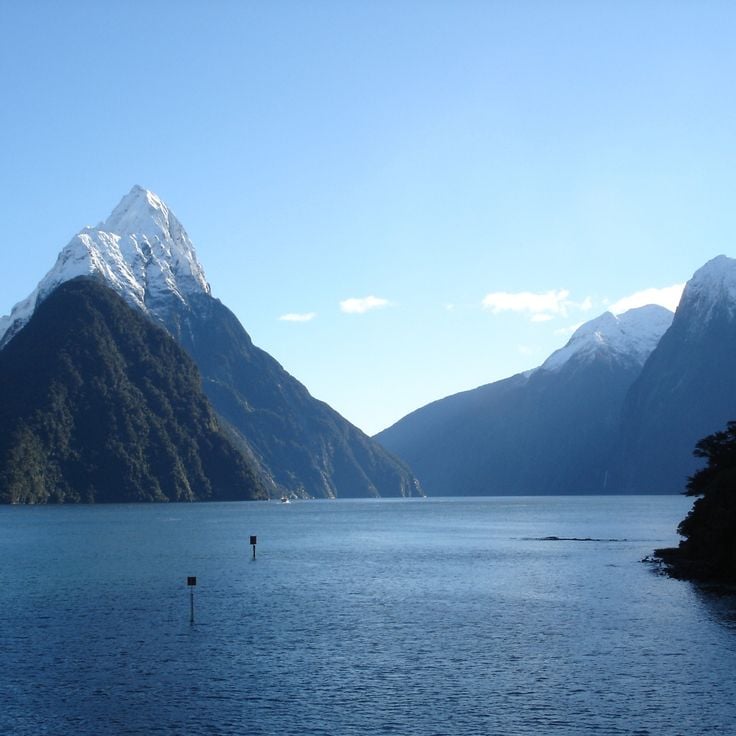
This fjord in Fiordland National Park on the southwest coast of New Zealand's South Island extends 15 kilometers (9.3 miles) inland and is flanked by forested cliffs rising up to 1,200 meters (3,900 feet). Milford Sound / Piopiotahi sits in a region that receives an average of 180 days of rain annually, creating numerous temporary waterfalls that cascade down the rock faces. The fjord was carved by glaciers during ice ages and later flooded by rising sea levels, with Mitre Peak as the most recognizable formation rising 1,692 meters (5,551 feet) directly from the water.
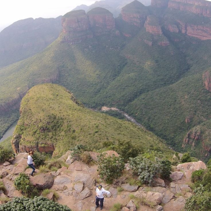
This canyon in Mpumalanga is one of the largest green gorges on Earth and provides views of cliff faces several hundred feet high, forested valleys and geological formations such as the Three Rondavels. The Blyde River has carved through red sandstone layers over millions of years to create a gorge approximately 16 miles (26 kilometers) long with depths reaching up to 2,600 feet (800 meters). Multiple viewpoints along the Panorama Route allow views of the Drakensberg Mountains, waterfalls and the valley floor where subtropical vegetation thrives. The Blyde River Canyon ranks among the geographically significant observation points in southern Africa.
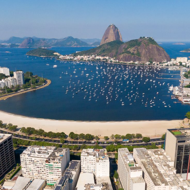
This granite and gneiss outcrop rises 1,300 feet (396 meters) above Guanabara Bay and forms one of Rio de Janeiro's defining landmarks. Sugarloaf Mountain was shaped by volcanic activity 600 million years ago and received its present contours through millennia of erosion. A two-stage cable car system, in operation since 1912, connects the city level through Morro da Urca to the summit, carrying visitors to viewing platforms that overlook Copacabana and Ipanema beaches, the Christ the Redeemer statue on Corcovado, and the surrounding mountain ranges.
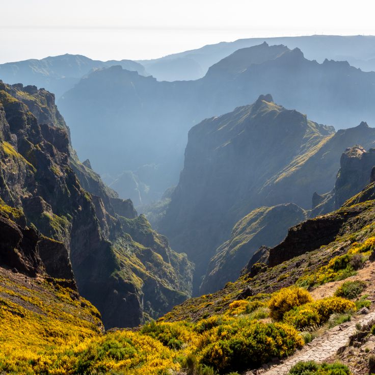
This summit sits in the central mountain range of Madeira and reaches 5906 feet (1800 meters). From Pico do Arieiro, sight lines extend across volcanic crater landscapes, cloud banks, and neighboring ridges. The viewpoint is accessible by paved road and serves as a starting point for trails leading to other peaks on the island. On clear days, the elevated position allows views toward the northern coast and surrounding valleys.
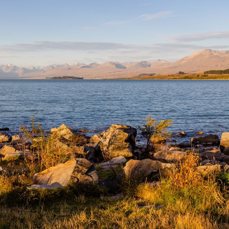
This alpine lake sits on the eastern shore of Lake Tekapo in the Mackenzie Basin, offering 32 square miles (83 square kilometers) of turquoise water colored by fine glacial particles. The lake rests at 2,330 feet (710 meters) elevation and is fed by the Godley River and smaller tributaries draining from the New Zealand Alps glacial system. The settlement developed during construction of the Upper Waitaki hydroelectric scheme and now serves as a base for observations at the Aoraki Mackenzie International Dark Sky Reserve, one of the largest such reserves in the southern hemisphere.
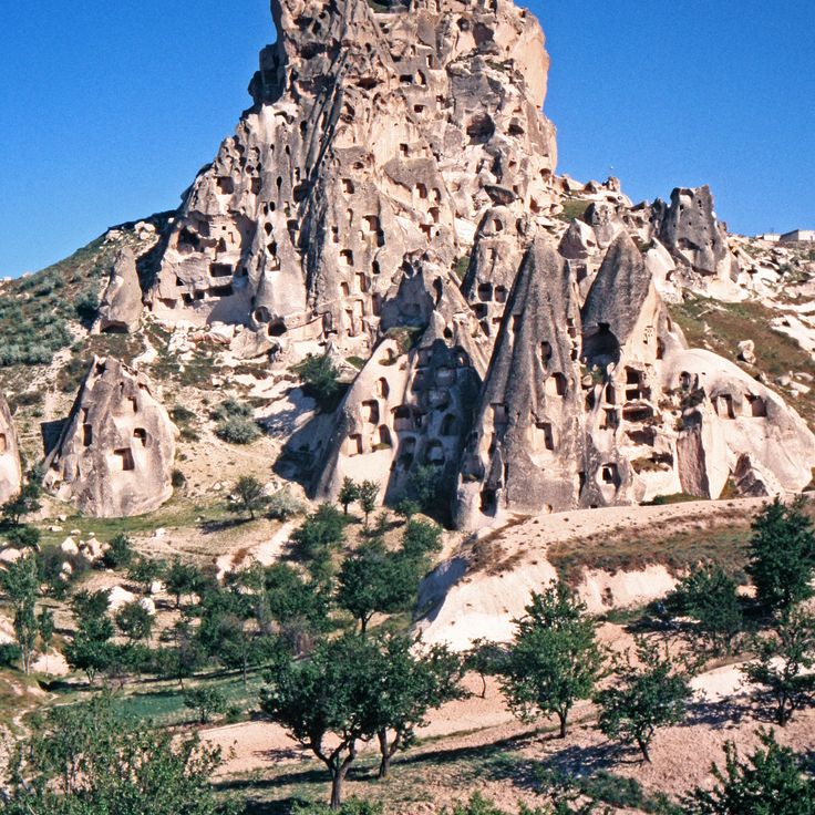
This region in Central Anatolia was shaped by volcanic activity and erosion over millions of years. The soft tufa rock served as shelter and religious space for centuries. The Göreme Valley contains Byzantine rock-cut churches decorated with frescoes from the 10th to 12th centuries. Wind and water carved the fairy chimneys, cone-shaped towers that define the terrain. From several vantage points, the extent of the valleys and the density of carved dwellings become apparent. Cappadocia sits roughly 174 miles (280 kilometers) southeast of Ankara on a high plateau at about 3,300 feet (1,000 meters) elevation.
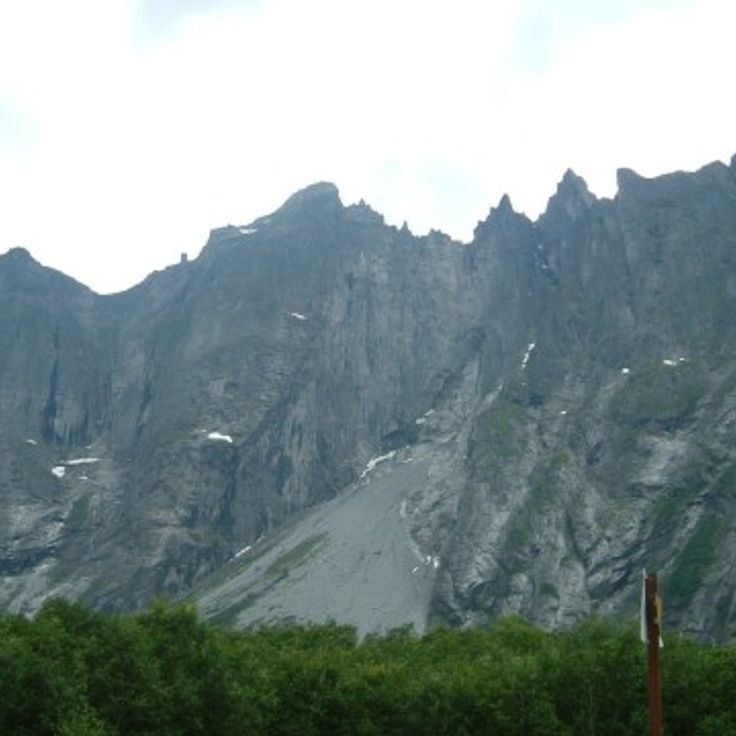
This wall rises 3,600 feet (1,100 meters) above the Romsdalen Valley and forms one of the tallest vertical cliffs in Europe. The Troll Wall consists of gray granite and has attracted climbers from various countries since the 1960s. The viewing point at the valley floor allows a view of the entire north face, while a plateau extends above the cliff. The area belongs to the Trolltindene mountain range and sits about 19 miles (30 kilometers) south of Åndalsnes in western Norway.
Laguna Colorada sits at 14,042 feet (4,278 meters) in Eduardo Abaroa Andean Fauna National Reserve in southwestern Bolivia near the Chilean border. This shallow salt lake spans 23 square miles (60 square kilometers) and derives its red coloration from algae and sediments in the water. Three species of flamingos, including the rare James's flamingo, feed on microorganisms here. The surrounding altiplano displays volcanic formations and fluctuating water levels that change the appearance of the lagoon throughout the year.
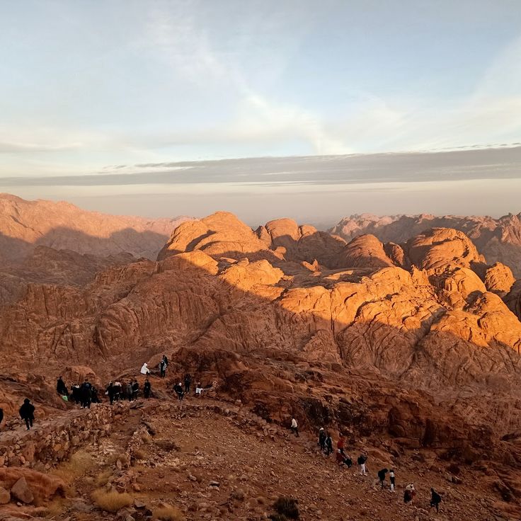
This mountain in the southern Sinai Peninsula reaches an elevation of 7,497 feet (2,285 meters) and stands as one of the most significant religious sites in the Middle East. Mount Sinai is revered in Jewish, Christian and Islamic traditions as the location where Moses received the Ten Commandments. Visitors can reach the summit via two routes: the Camel Path with approximately 3,750 steps, or the steeper Steps of Repentance with around 3,000 stone stairs. From the summit, views extend across the jagged mountain ranges of the Sinai, the desert plains below, and on clear days, the Gulf of Suez and the Gulf of Aqaba.
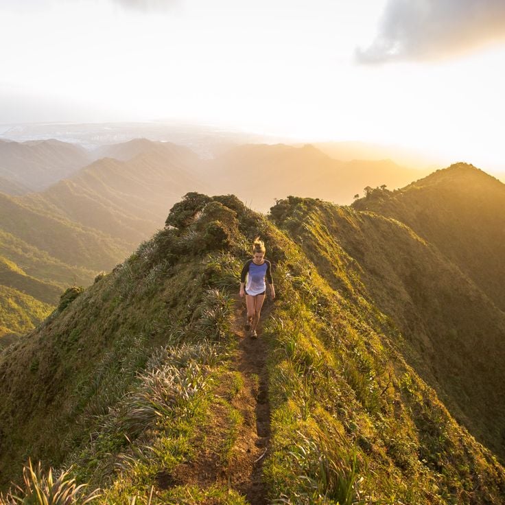
The Haiku Stairs consist of a metal stairway with 3,922 steps leading to the summit of Mount Puʻukeahiakahoe on the island of Oʻahu. The stairs were originally constructed during World War II for military purposes and follow a steep mountain ridge. From various points along the route, views extend across the Windward Coast, the Koʻolau Range, and the Pacific Ocean. The structure ascends approximately 2,000 feet (610 meters) and passes through multiple vegetation zones of the Hawaiian mountain landscape.
The Great Wall extends over 13000 miles (21000 kilometers) across China and was built between the 7th century BCE and the 16th century. This fortification runs through mountains, plains, and deserts, providing numerous observation points overlooking the surrounding landscapes. From various sections, visitors can observe the wall's winding structure as it stretches across mountain ridges and valleys, offering views into the historical defense system.
The Cliffs of Moher rise 700 feet (214 meters) above the Atlantic Ocean and extend for 9 miles (14 kilometers) along Ireland's western coast. These limestone cliffs offer wide views of the ocean, the Aran Islands, and Galway Bay. The viewpoint is located in County Clare and provides observation of the geological formations from the Carboniferous period, formed approximately 320 million years ago. The cliffs host numerous seabird colonies and are part of the Burren and Cliffs of Moher UNESCO Geopark.
The Colorado River has carved this 277-mile (446-kilometer) canyon through rock over millions of years. The Grand Canyon extends across northern Arizona and reaches depths of up to 6,000 feet (1,829 meters) in places. The different rock layers exposed along the canyon walls document nearly two billion years of geological history. Multiple viewpoints along the South Rim and North Rim provide direct views into the gorge and of the river below.
Mount Everest reaches an elevation of 29,029 feet (8,848 meters) above sea level and marks the border between Nepal and Tibet. This mountain forms the highest point on Earth and lies within the Himalayan range. From various observation points in the region, the summit and surrounding mountain chains can be viewed. The mountain attracts climbers and visitors who seek to experience the high-altitude landscape.
The Iguazú Falls mark the border between Brazil and Argentina where the Iguazú River plunges over a basalt cliff. The system consists of 275 individual waterfalls extending across a width of roughly 1.7 miles (2.7 kilometers). The tallest waterfall, known as the Devil's Throat, reaches a height of 269 feet (82 meters). The falls sit within two national parks, both designated as UNESCO World Heritage sites. From the Brazilian side, frontal views encompass the entire waterfall chain and the surrounding subtropical rainforest. The permanent water mist generates numerous rainbows under appropriate light conditions.
Victoria Falls marks the point where the Zambezi River drops approximately 355 feet (108 meters) across a width of roughly 5,600 feet (1.7 kilometers) into a narrow gorge. Located on the border between Zambia and Zimbabwe, these falls rank among the largest waterfalls in the world and generate a continuous spray cloud visible from considerable distances. Several viewpoints along the gorge provide direct sightlines to the falling water and the surrounding river landscape.
The Pyramids of Giza are three monumental pharaonic tombs from the Old Kingdom, built approximately 4,500 years ago. These archaeological structures on the outskirts of Cairo represent some of the oldest surviving constructions made by humanity. The complex includes the Great Pyramid of Khufu, the Pyramid of Khafre, and the Pyramid of Menkaure, accompanied by the Sphinx and several smaller satellite pyramids. From various vantage points, the pyramids provide views across the desert landscape and the nearby urban area.
Uluru rises 1,142 feet (348 meters) above the surrounding desert plain in the heart of the Northern Territory and measures 5.8 miles (9.4 kilometers) in circumference. This sandstone monolith changes color with the sunlight and holds cultural importance for the Anangu people. The rock formation developed approximately 550 million years ago and displays traces of caves, watercourses, and traditional rock paintings. Several viewing points around the base provide observations of this geological feature set within the desert landscape of central Australia.
Ha Long Bay spans roughly 600 square miles and contains over 1,600 limestone islands and rock formations rising from the green waters. This marine bay sits in the Gulf of Tonkin, and its limestone formations developed over millions of years through geological processes. The bay provides vantage points from boats, kayak tours, and elevated islands, from which visitors can observe the numerous islands, hidden caves, and turquoise waters. The formations range from a few feet to nearly 650 feet in height.
Banff National Park spans 2564 square miles (6641 square kilometers) and includes glaciers, ice fields, coniferous forests, and alpine terrain in the Canadian Rockies. Viewpoints throughout the park provide sights of turquoise glacial lakes, including Lake Louise and Moraine Lake, along with peaks reaching over 10000 feet (3000 meters). Mountain roads and trails lead to observation points overlooking the Bow Range, Waputik Mountains, and Bow Valley. Winter transforms the mountain slopes into ski areas, while summer months open access to higher elevation passes and ridges.
Santorini is a volcanic island in the Aegean Sea, known for its white buildings with blue domes perched on steep cliffs above the water. The caldera was formed by a volcanic eruption approximately 3,600 years ago and now creates a semicircular bay reaching depths of up to 1,300 feet (400 meters). The villages of Oia, Fira, and Imerovigli line the crater rim and provide observation points overlooking the surrounding islands of Thirasia and Nea Kameni. The cliffs display multicolored rock layers of volcanic material that document the island's geological history.
This rainforest spans 2.1 million square miles (5.5 million square kilometers) and contains over 40,000 plant species and 1,300 bird species. The observation points provide views of the dense canopy extending to the horizon and reveal the layered vegetation levels. Rivers wind through the greenery, forming waterways visible from elevated vantage points. These viewing locations convey the geographic scale of this forested area.
The Norwegian fjords extend over a hundred miles inland and are flanked by steep rock walls that rise several hundred feet from the water. These deep sea inlets were carved by glacial erosion during the Ice Age and form one of the most distinct geological features of Norway's western coast. The region encompasses numerous branching waterways, including Geirangerfjord and Storfjord, which cut through the mountainous landscape and provide access to remote valleys and settlements.
The Alhambra is a Moorish palace from the 13th century located on a hill above Granada. The complex displays Islamic architecture with decorated arches, geometric patterns, and ceramic tiles throughout its courtyards and halls. From the fortification walls and towers, the Alhambra provides views over the city of Granada, the Sierra Nevada, and the surrounding Andalusian plains. The Generalife gardens extend across the adjacent slopes and complement the palace architecture.
The Taj Mahal is a white marble mausoleum built in the 17th century that combines Persian, Ottoman, and Indian architectural styles. This monumental structure rises on the banks of the Yamuna River and was commissioned by Mughal Emperor Shah Jahan to commemorate his deceased wife Mumtaz Mahal. The structure includes a central domed chamber, four minarets at the corners, and extensive Mughal-style gardens. The facades feature inlay work with semiprecious stones and calligraphic inscriptions. The mausoleum serves as a significant example of Mughal architecture.
The Niagara Falls comprise three waterfalls that flow across cliffs at the border between Canada and the United States. Water passes over the falls at a rate of approximately 85,000 cubic feet per second (2,400 cubic meters per second). Observation points on the Canadian side provide views of the Horseshoe Falls, American Falls, and Bridal Veil Falls. The cliffs formed through erosion of the Niagara Escarpment, a geological feature extending across the region. Visitors can observe the water flow from various perspectives, including platforms along the gorge and elevated locations overlooking the entire formation.
Preikestolen rises 1,982 feet (604 meters) above the Lysefjord and forms a rock platform roughly 82 feet (25 meters) wide. This formation provides views over the Norwegian fjord system and the surrounding mountains of the Rogaland region. The flat surface of the rock ledge ends at a nearly vertical edge that drops directly above the fjord waters. Access follows a hiking trail that crosses through the mountainous landscape of southwestern Norway and traverses different elevations.
Horseshoe Bend displays a 270-degree turn of the Colorado River, which has carved 300 meters (984 feet) down into the red sandstone. This geological formation lies within Glen Canyon and is visible from the rim of a cliff that provides a direct view of the horseshoe-shaped river loop. The viewpoint sits near Page and allows visitors to observe the erosive forces that have shaped this landscape over millions of years. The Navajo Sandstone walls surround the river and form a natural amphitheater in the Arizona desert terrain.
Angels Landing is a 453-foot (138-meter) rock formation rising above the valley in Zion National Park. This viewpoint is reached via a hiking trail that includes narrow paths with anchored safety chains, guiding hikers to the summit. From this position, views extend across Zion Canyon, the surrounding sandstone cliffs, and the Virgin River valley below. The formation provides a geographically significant vantage point for observing the geological structures of the Colorado Plateau.
This volcanic black sand beach lies on Iceland's southern coast near Vík í Mýrdal, one of the wettest villages in the country. The dark basalt grains come from cooled lava of past eruptions, ground into fine sand by the Atlantic Ocean. From the beach, visitors see the Reynisdrangar sea stacks offshore, which local folklore describes as trolls turned to stone. The shoreline is flanked by Hálsanefshellir, a basalt column cave formed by erosion. The area experiences strong winds and unpredictable waves, requiring visitors to maintain distance from the surf.
This ancient city in Jordan contains over 800 monuments carved into red sandstone cliffs, including tombs, temples, and altars. Petra offers numerous vantage points from which visitors can observe the monumental architecture and surrounding desert landscape. The rock faces, which extend throughout the site, provide panoramic views of the Nabataean structures and the rugged canyons of the region.
Mount Kilimanjaro is a 19,341-foot (5,895-meter) volcano with three extinct volcanic cones that rises amid a savanna landscape. The mountain provides viewpoints along its ascent routes where visitors can observe the surrounding plains, mountain forests, and glacial formations at the summit. The mountain's different elevation zones display varying vegetation types and geological features.
The granite peaks of the Fitz Roy mountain range rise to 11,171 feet (3,405 meters) and form a distinctive formation in Los Glaciares National Park. The massif lies in the Patagonian Andes and extends along the border between Argentina and Chile. The steep rock walls and glaciers attract climbers and hikers from various regions. The surrounding valleys provide access to several observation points from which the jagged peaks and surrounding mountain landscape become visible.
This volcanic island in the South Pacific rises around Mount Otemanu, which reaches over 2300 feet (700 meters) above the surrounding water. The atoll is encircled by a lagoon separated from the open ocean by a coral reef. The island is part of the Society Islands archipelago and provides viewing points of the central mountain's steep slopes, the turquoise waters of the lagoon, and the small islands scattered along the outer reef. From several locations, visitors can observe the mountain's distinctive double-peak formation and the contrasts between the dark volcanic rock and the light coral sand.
Mount Fuji is the tallest mountain in Japan, reaching an elevation of 12,388 feet (3776 meters) above sea level. This volcanic peak dominates the landscape of Honshu Island and offers expansive views from its summit across the surrounding plains, forests, and on clear days toward Tokyo. At the top, a crater measuring approximately 1640 feet (500 meters) in diameter marks the mountain's volcanic origin. The mountain serves as an important observation point from which visitors can survey the geographic formations of the region and the expanse of the Japanese countryside.
Easter Island contains 887 recorded monumental stone figures created between 1250 and 1500. These statues, known as moai, stand along the coastline and inland areas, providing views across the South Pacific. The island is located 2237 miles (3600 kilometers) west of the Chilean coast and allows observation of the volcanic landscape with three extinct volcanoes. The stone platforms where the moai were erected are positioned at elevated points overlooking the ocean and surrounding terrain.
Plitvice Lakes National Park consists of 16 lakes at different elevations, connected by 92 waterfalls flowing over limestone formations. The water system extends across a forested area and forms natural travertine barriers that separate the lakes from one another. The lakes range from 1476 feet (450 meters) to 2067 feet (630 meters) above sea level. Visitors can explore the area on wooden walkways and hiking trails to observe the various waterfalls and surrounding vegetation.
Zhangjiajie National Forest Park is located in Hunan Province and contains over 3000 quartzite sandstone pillars, many of which exceed heights of 200 meters (656 feet). These geological formations rise from dense forest and create a landscape of gorges, natural bridges, and waterfalls. The area was designated as China's first national forest reserve and forms part of the larger Wulingyuan scenic area. Visitors can observe the formations from various viewpoints along hiking trails and through a glass elevator system that provides access to elevated platforms.
Monument Valley extends across the Colorado Plateau and presents distinct red sandstone formations that rise up to 1,000 feet (300 meters) above the desert floor. These geological structures have been shaped by erosion over millions of years and form isolated mesas, buttes, and spires. The valley lies within the Navajo Nation and provides viewpoints of the characteristic formations that stand against the desert sky and allow extensive sightlines across the surrounding landscape.
This rock formation extends horizontally about 2,300 feet (700 meters) above Lake Ringedalsvatnet in Ullensvang, providing views across the fjord-marked landscape of the Hardangervidda region. Reaching Trolltunga requires a hike of roughly 12 to 14 miles (20 to 22 kilometers) round trip through varied terrain with an elevation gain of approximately 3,000 feet (900 meters).
Dyrhólaey is a prominent rock formation on Iceland's southern coast that rises approximately 400 feet (120 meters) above the Atlantic and forms a natural arch large enough for small boats to pass through in calm conditions. From this observation point, views extend across the black sand beaches of Reynisfjara to the east and the Mýrdalsjökull glacier to the north. The cliffs serve as nesting grounds for puffins, which are present in large numbers between May and August. This cape marks the southernmost point of Iceland's mainland and offers views of waves breaking against the volcanic basalt columns along the shore.
The Meteora monasteries stand on sandstone pillars that rise up to 1,300 feet (400 meters) above the Thessaly plain. This complex consists of six active Orthodox monasteries built between the 14th and 16th centuries atop natural rock towers. The monastery terraces provide views across the Pinios River valley and surrounding mountain formations.
This flat topped mountain rises more than 3,280 feet (1,000 meters) above Cape Town and the Atlantic Ocean. The summit plateau extends over 1.9 miles (3 kilometers) in length and provides views across the city, Robben Island, the Cape Peninsula and the South African interior. Visitors reach the summit by rotating cable car or via several hiking trails through fynbos vegetation.
Torres del Paine is a 935 square mile (2,420 square kilometer) national park in southern Chile between the Strait of Magellan and the Argentine border. Established in 1959, this park forms a high mountain landscape with three distinct granite towers rising roughly 8,200 feet (2,500 meters) above the Patagonian steppe. The terrain comprises glacial fields, several lakes, extensive glaciers and river valleys shaped by ice flows from the Southern Patagonian Ice Field. Visitors reach the park via Puerto Natales, approximately 70 miles (112 kilometers) south of the main entrance.
This slot canyon near Page in Arizona displays sandstone formations carved by water erosion over thousands of years. The passages range from a few inches to several feet in width, and openings in the ceiling allow daylight to illuminate the undulating walls. The canyon is divided into two sections: Upper Antelope Canyon and Lower Antelope Canyon, both located on Navajo land. Visitors can observe the geological structures and light effects that vary depending on time of day and season. Access is exclusively through guided tours.
This table mountain on the border of Brazil, Venezuela and Guyana rises to 9,219 feet (2,810 meters) above sea level and stands among the oldest geological formations on Earth. Mount Roraima offers views across the Guiana Highlands, where tropical rainforest meets sheer sandstone cliffs. The flat summit plateau extends roughly 12 square miles (31 square kilometers) and features weathered rock formations, endemic plant species and waterfalls cascading from the edges. The multi-day trek to the summit passes through several vegetation zones and provides views of neighboring tepuis and the Venezuelan Gran Sabana.
This viewpoint at Skógafoss provides access to a 200-foot waterfall in southern Iceland, where the Skógá River drops over former sea cliffs. The location offers close-range views from the base and an elevated platform reached by stairway, with sight lines extending across the coastal plain toward the Atlantic Ocean.
This overlook in Grand Teton National Park sits at the northern end of the Teton Range and provides open views across the Willow Flats wetlands and the Snake River. The Teton Range rises behind the floodplain, with the Grand Teton reaching 13,775 feet (4,199 meters). The area serves as habitat for moose, bison and waterfowl, particularly during morning and evening hours. Access is via US Highway 89/191/287 between Jackson Lake and Moran Junction. Parking is available, and the viewpoint is directly accessible from the road.
Bryce Canyon National Park presents a remarkable assembly of rock spires and amphitheaters in southern Utah. These geological formations developed through erosion processes over millions of years, creating a landscape of orange, red, and white limestone columns. The protected area spans more than 56 square miles (145 square kilometers) and offers several viewpoints along the edge of the Paunsaugunt Plateau at elevations between 8,000 and 9,100 feet (2,400 to 2,800 meters).
This 12,218-foot peak is New Zealand's highest mountain and dominates the Southern Alps. Aoraki / Mount Cook sits within a national park shaped by glaciers, icefields and alpine ridges. The view from the summit and surrounding observation points reveals glaciated slopes, deep valleys and the Canterbury Plains to the east.
This fjord in Fiordland National Park on the southwest coast of New Zealand's South Island extends 15 kilometers (9.3 miles) inland and is flanked by forested cliffs rising up to 1,200 meters (3,900 feet). Milford Sound / Piopiotahi sits in a region that receives an average of 180 days of rain annually, creating numerous temporary waterfalls that cascade down the rock faces. The fjord was carved by glaciers during ice ages and later flooded by rising sea levels, with Mitre Peak as the most recognizable formation rising 1,692 meters (5,551 feet) directly from the water.
This canyon in Mpumalanga is one of the largest green gorges on Earth and provides views of cliff faces several hundred feet high, forested valleys and geological formations such as the Three Rondavels. The Blyde River has carved through red sandstone layers over millions of years to create a gorge approximately 16 miles (26 kilometers) long with depths reaching up to 2,600 feet (800 meters). Multiple viewpoints along the Panorama Route allow views of the Drakensberg Mountains, waterfalls and the valley floor where subtropical vegetation thrives. The Blyde River Canyon ranks among the geographically significant observation points in southern Africa.
This granite and gneiss outcrop rises 1,300 feet (396 meters) above Guanabara Bay and forms one of Rio de Janeiro's defining landmarks. Sugarloaf Mountain was shaped by volcanic activity 600 million years ago and received its present contours through millennia of erosion. A two-stage cable car system, in operation since 1912, connects the city level through Morro da Urca to the summit, carrying visitors to viewing platforms that overlook Copacabana and Ipanema beaches, the Christ the Redeemer statue on Corcovado, and the surrounding mountain ranges.
This summit sits in the central mountain range of Madeira and reaches 5906 feet (1800 meters). From Pico do Arieiro, sight lines extend across volcanic crater landscapes, cloud banks, and neighboring ridges. The viewpoint is accessible by paved road and serves as a starting point for trails leading to other peaks on the island. On clear days, the elevated position allows views toward the northern coast and surrounding valleys.
This alpine lake sits on the eastern shore of Lake Tekapo in the Mackenzie Basin, offering 32 square miles (83 square kilometers) of turquoise water colored by fine glacial particles. The lake rests at 2,330 feet (710 meters) elevation and is fed by the Godley River and smaller tributaries draining from the New Zealand Alps glacial system. The settlement developed during construction of the Upper Waitaki hydroelectric scheme and now serves as a base for observations at the Aoraki Mackenzie International Dark Sky Reserve, one of the largest such reserves in the southern hemisphere.
This region in Central Anatolia was shaped by volcanic activity and erosion over millions of years. The soft tufa rock served as shelter and religious space for centuries. The Göreme Valley contains Byzantine rock-cut churches decorated with frescoes from the 10th to 12th centuries. Wind and water carved the fairy chimneys, cone-shaped towers that define the terrain. From several vantage points, the extent of the valleys and the density of carved dwellings become apparent. Cappadocia sits roughly 174 miles (280 kilometers) southeast of Ankara on a high plateau at about 3,300 feet (1,000 meters) elevation.
This wall rises 3,600 feet (1,100 meters) above the Romsdalen Valley and forms one of the tallest vertical cliffs in Europe. The Troll Wall consists of gray granite and has attracted climbers from various countries since the 1960s. The viewing point at the valley floor allows a view of the entire north face, while a plateau extends above the cliff. The area belongs to the Trolltindene mountain range and sits about 19 miles (30 kilometers) south of Åndalsnes in western Norway.
Laguna Colorada sits at 14,042 feet (4,278 meters) in Eduardo Abaroa Andean Fauna National Reserve in southwestern Bolivia near the Chilean border. This shallow salt lake spans 23 square miles (60 square kilometers) and derives its red coloration from algae and sediments in the water. Three species of flamingos, including the rare James's flamingo, feed on microorganisms here. The surrounding altiplano displays volcanic formations and fluctuating water levels that change the appearance of the lagoon throughout the year.
This mountain in the southern Sinai Peninsula reaches an elevation of 7,497 feet (2,285 meters) and stands as one of the most significant religious sites in the Middle East. Mount Sinai is revered in Jewish, Christian and Islamic traditions as the location where Moses received the Ten Commandments. Visitors can reach the summit via two routes: the Camel Path with approximately 3,750 steps, or the steeper Steps of Repentance with around 3,000 stone stairs. From the summit, views extend across the jagged mountain ranges of the Sinai, the desert plains below, and on clear days, the Gulf of Suez and the Gulf of Aqaba.
The Haiku Stairs consist of a metal stairway with 3,922 steps leading to the summit of Mount Puʻukeahiakahoe on the island of Oʻahu. The stairs were originally constructed during World War II for military purposes and follow a steep mountain ridge. From various points along the route, views extend across the Windward Coast, the Koʻolau Range, and the Pacific Ocean. The structure ascends approximately 2,000 feet (610 meters) and passes through multiple vegetation zones of the Hawaiian mountain landscape.