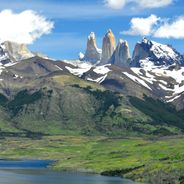
Torres del Paine National Park, National park in Chilean Patagonia
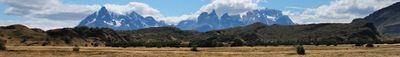
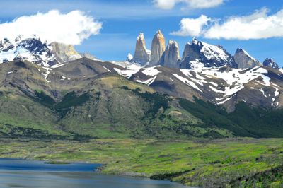
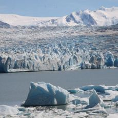
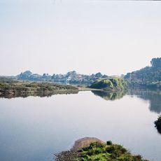
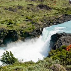
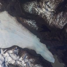
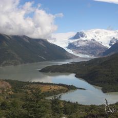
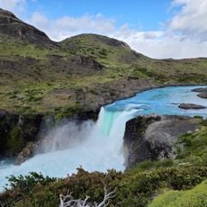
The park spans 181,414 hectares (448,230 acres) of protected land between Magellanic forests and Patagonian steppes, encompassing granite peaks, glaciers, lakes, and rivers. Turquoise waters wind through valleys beneath the towering mountain ranges, while extensive ice fields cling to higher elevations. Vegetation ranges from dense southern beech forests in wetter zones to open grasslands shaped by wind.
Lady Florence Dixie provided the first recorded description in 1880, referring to the three granite towers as Cleopatra's Needles. The Chilean government declared the territory a national park in 1959 after earlier attempts to use it for ranching failed. A devastating fire in 2011 burned over 17,000 hectares (42,000 acres), leading to stricter regulations for visitors and camping activities.
The indigenous Tehuelche named the region Paine, meaning blue in their language, reflecting their deep connection to this mountainous territory. For centuries, the area served as hunting grounds and spiritual landscape for nomadic groups who traveled between the steppes and forests. Today, hikers and nature enthusiasts from across continents visit the park, contributing to the regional economy of nearby settlements.
Visitors reach the park from Puerto Natales, located 70 miles (112 kilometers) to the south, and can choose between hotels, mountain shelters, or campgrounds. The best time to visit is from October through April during the Patagonian summer when days are longer and weather conditions become milder. Hikers must book their overnight stays in advance, and open fires are prohibited throughout the park since the 2011 blazes.
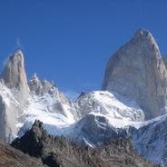
The park contains three distinct granite towers that rise from the Paine mountain range, forming natural landmarks visible from considerable distances. The peaks formed roughly twelve million years ago through volcanic activity and subsequent erosion by glaciers. The middle tower reaches 8,200 feet (2,500 meters) in elevation and presents a popular challenge for technical climbers.
Location: Torres del Paine
Location: Última Esperanza Province
Inception: May 13, 1959
Elevation above the sea: 579 m
Operator: conaf
Shares border with: Bernardo O'Higgins National Park, Los Glaciares National Park
Website: http://parquetorresdelpaine.cl/en
GPS coordinates: -50.98306,-72.96639
Latest update: November 27, 2025 20:56
From the highest peaks to coastal cliffs, this collection brings together geographically significant observation points across all continents. The locations offer views of mountain ranges, waterfalls, deserts, oceans, and notable architectural structures. The selection includes the Great Wall near Beijing, the Cliffs of Moher above the Atlantic, the Grand Canyon in Arizona, and Mount Everest on the Nepal-Tibet border. Among the waterfalls are Iguazú Falls between Brazil and Argentina, Victoria Falls between Zambia and Zimbabwe, and Niagara Falls between Canada and the United States. The Pyramids of Giza, the Alhambra in Granada, and the Taj Mahal in Agra showcase important architectural achievements from different eras. Natural formations such as Uluru in the Australian outback, Halong Bay in Vietnam, Banff National Park in the Canadian Rockies, and the Norwegian fjords demonstrate Earth's geological diversity. Additional locations include Santorini in the Aegean Sea, the Amazon rainforest, Horseshoe Bend on the Colorado River, Petra in Jordan, Mount Kilimanjaro in Tanzania, the Fitz Roy range in Patagonia, and Plitvice Lakes National Park in Croatia.
This collection leads to places that remain outside standard tourist circuits. The selection includes natural landscapes and cultural sites that receive limited attention from international visitors. From the salt flats of Bolivia to ancient ruins in Turkish mountain terrain and the ice formations of Lake Baikal, the collection provides access to less frequented regions. Natural phenomena include the Benagil Cave along Portugal's Algarve coast, the Great Blue Hole off Belize, and the sandstone formations of The Wave in Arizona. Cultural sites such as Quinta da Regaleira near Lisbon, the abandoned nitrate town of Humberstone in Chile, and the fortified Berber village of Ait Benhaddou in Morocco show historical building methods and past ways of life. The Meteora monasteries in Greece and the Waitomo glowworm caves in New Zealand demonstrate the connection between human settlement and natural environment. The locations span all continents and climate zones. They range from tropical regions like the turquoise river at Hinatuan in the Philippines, through temperate zones like the Cinchado rock formation on Tenerife, to remote areas such as Pangong Lake in Indian Ladakh and the limestone pinnacles of Tsingy de Bemaraha in Madagascar. The collection allows travelers to experience regional characteristics without commercial tourism infrastructure.
Patagonia extends across the southern reaches of Chile and Argentina, encompassing a range of natural landscapes from active glaciers to volcanic peaks. The region presents a mixture of ice, stone and water, with national parks protecting thousands of square miles of undeveloped terrain. The land was shaped by glacial processes that left deep valleys, lakes and dramatic mountain formations. The collection includes prominent locations across both countries. In Argentina, Mount Fitz Roy and Cerro Torre rise above the valley of El Chaltén, while Perito Moreno Glacier is one of the few ice formations worldwide that continues to advance. Los Alerces National Park protects ancient alerce trees that have stood for millennia. On the Chilean side, the Marble Caves at General Carrera Lake form carved rock structures, Queulat Hanging Glacier feeds waterfalls, and the towers of Torres del Paine define one of South America's most recognizable mountain landscapes. San Rafael Lagoon provides access to tidewater glaciers, while remote protected areas such as Kawésqar National Park and Pumalín Douglas Tompkins National Park preserve extensive temperate rainforests. Historical sites like Cave of Hands display prehistoric rock art.
Chile stretches over 2,670 miles (4,300 kilometers) from north to south, crossing some of South America's most varied landscapes. The north features the Atacama Desert with its salt flats, geysers at El Tatio, and astronomical observatories such as Paranal. The coastal city of Valparaíso displays colonial architecture on steep hillsides, while the abandoned nitrate mining towns of Humberstone and Sewell recall the country's industrial past. The Andean region includes active volcanoes like Villarrica and Osorno, and Lauca National Park with Lake Chungará at over 14,760 feet (4,500 meters) elevation. The Lake District and Patagonia offer extensive forests, glaciers, and fjords. Torres del Paine National Park attracts hikers with its granite peaks and Grey Glacier. Lake General Carrera on the Argentine border shows turquoise waters, while Queulat and Bernardo O'Higgins national parks preserve remote wilderness. Chiloé Island is known for its wooden churches and traditional architecture. Further south, Puerto Williams on Navarino Island marks one of the world's southernmost settlements. Easter Island sits 2,300 miles (3,700 kilometers) west of the coast in the Pacific, displaying over 900 moai statues from its Polynesian past. The Juan Fernández Archipelago, also in the Pacific, offers endemic flora and fauna. In central Chile, ski resorts like Valle Nevado provide winter sports in the Andes, while the Elqui Valley is recognized for pisco production and clear night skies. Santiago, the capital, sits in an Andean valley and serves as a starting point for trips to surrounding national parks such as La Campana.
Perito Moreno Glacier
55.9 km
Los Glaciares National Park
109.5 km
Cueva del Milodón Natural Monument
69.2 km
Grey Glacier
20.2 km
Water resources management in Chile
20.2 km
Spegazzini Glacier
86.7 km
Amalia Glacier
46.2 km
Última Esperanza Sound
55.6 km
Salto Grande
9.8 km
Aguilera
92.2 km
Glaciarium
84.5 km
Tyndall Glacier
37.1 km
Punta Walichu - Reserva Natural y Arqueológica
93.7 km
Frigorífico Bories
84.6 km
Peel Fjord
73.7 km
Parque provincial Península de Magallanes
65.2 km
Dickson Glacier
25.7 km
Eberhard Fjord
71.1 km
Seco Glacier
93.1 km
Cerro Benítez
68.6 km
Onelli Glacier
101.4 km
Fjord of the Mountains
94 km
Sierra Dorotea
82.6 km
Cerro Mayo (verdadero Stokes)
76.2 km
Onelli glacier
109.8 km
Cueva del Milodón Grande
72.7 km
Museo Regional (Municipal)
87.5 km
Kusanovic Bridge
11.5 kmReviews
Visited this place? Tap the stars to rate it and share your experience / photos with the community! Try now! You can cancel it anytime.
Discover hidden gems everywhere you go!
From secret cafés to breathtaking viewpoints, skip the crowded tourist spots and find places that match your style. Our app makes it easy with voice search, smart filtering, route optimization, and insider tips from travelers worldwide. Download now for the complete mobile experience.
A unique approach to discovering new places❞
— Le Figaro
All the places worth exploring❞
— France Info
A tailor-made excursion in just a few clicks❞
— 20 Minutes