Enable Location

We need your location to show you interesting places around you

Discover nearby places

Find interesting locations and hidden gems around you

Precise directions

Get accurate directions and distances to places

Your location is never shared with other users. It's only used when you tap the location button.

Abbey Farm House, Yeovil

Log in to your account

Start exploring — it's free

Trusted by 62,033 travelers worldwide

Continue with Google
Continue with Apple
or

We will send you a code to connect

By continuing, you accept our Terms and Conditions and our Privacy Policy

Check your inbox

We've sent a pincode in your inbox. Please enter the code below.

Abbey Farm House, Yeovil

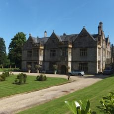
Abbey Farm House, Yeovil, Grade I listed farmhouse in Yeovil, England

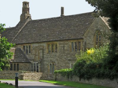
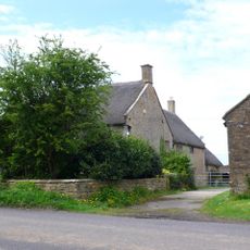
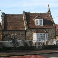
Abbey Farm House on Preston Road is a farmhouse from the early 15th century, built from local Ham stone with features typical of medieval agricultural buildings. Its Grade I listing underscores its architectural value and protected status under English heritage law.

The house was commissioned around 1420 by John Stourton, known as Jenkyn Stourton, and was originally named Preston Great Farm within Preston Plucknett manor. In the 19th century it acquired its current name, reframing its connection to the region's monastic past.

The building shows how prosperous farmers in Somerset lived and constructed their homes during medieval times. The structure tells of the craftsmanship and materials that were typical for such agricultural operations.

As a Grade I building, the house is viewable from the outside, but interior access is not freely available since it remains a private residence. You can appreciate the exterior facade and architecture from Preston Road to see the stone details and medieval construction methods.

The building received Grade I protection in 1951, making it one of the earlier safeguarded structures in the region. Its name change from Preston Great Farm to Abbey Farm House mirrors how local memory and meaning shifted with time.

The community of curious travelers

AroundUs brings together thousands of curated places, local tips, and hidden gems, enriched daily by 60,000 contributors worldwide.

Start exploring
Location
GPS coordinates
50.94470,-2.65556
Latest update
December 14, 2025 18:09
Around this place
Stable block about 70 metres west of Brympton House
United Kingdom

Stable block about 70 metres west of Brympton House

2.2 km
Naish Priory
United Kingdom

Naish Priory

2.7 km
Church of St John the Baptist, Yeovil
United Kingdom

Church of St John the Baptist, Yeovil

1.7 km
Newton Surmaville
United Kingdom

Newton Surmaville

2.9 km
Abbey Barn, Yeovil
United Kingdom

Abbey Barn, Yeovil

399 m
St Andrew's Church
United Kingdom

St Andrew's Church

2.3 km
The Old Police Station
United Kingdom

The Old Police Station

1.8 km
All Saints' Church, Yeovil Marsh
United Kingdom

All Saints' Church, Yeovil Marsh

2.5 km
Museum of South Somerset
United Kingdom

Museum of South Somerset

1.6 km
Church of St James with Its South Boundary Wall
United Kingdom

Church of St James with Its South Boundary Wall

574 m
Church of St Andrew
United Kingdom

Church of St Andrew

1.9 km
172 And 174, Goldcroft Road
United Kingdom

172 And 174, Goldcroft Road

1.7 km
Church of St Peter and St Paul
United Kingdom

Church of St Peter and St Paul

2.6 km
Classic Yeovil
United Kingdom

Classic Yeovil

2 km
Brympton House
United Kingdom

Brympton House

2.3 km
Odeon
United Kingdom

Odeon

1.6 km
Milestone At Ngr St 5170 1635
United Kingdom

Milestone At Ngr St 5170 1635

2.3 km
The Hundred Stone At Ngr St556177
United Kingdom

The Hundred Stone At Ngr St556177

2.1 km
Milestone In Boundary Wall
United Kingdom

Milestone In Boundary Wall

1.7 km
Boundary Stone Opposite Junction With Main Street
United Kingdom

Boundary Stone Opposite Junction With Main Street

2.8 km
High Leaze Farmhouse
United Kingdom

High Leaze Farmhouse

2.2 km
Milestone, 83M South-West Of The Junction Between West Coker Road (A30) And Camp Road
United Kingdom

Milestone, 83M South-West Of The Junction Between West Coker Road (A30) And Camp Road

2.2 km
Milestone At Ngr St 5143 1573
United Kingdom

Milestone At Ngr St 5143 1573

2.7 km
Toll House With Boundary Walls, Gate And Railings
United Kingdom

Toll House With Boundary Walls, Gate And Railings

2.2 km
The Chantry House The Dower House
United Kingdom

The Chantry House The Dower House

2.3 km
Newton Lodge
United Kingdom

Newton Lodge

2.2 km
Milestone, Ilchester Road, by No.134, opp. Picketty Witch PH
United Kingdom

Milestone, Ilchester Road, by No.134, opp. Picketty Witch PH

1.2 km
Milestone, Tintinhull Road, Coppitts Rise, between equestrian centre and Vagg Farm crossroads
United Kingdom

Milestone, Tintinhull Road, Coppitts Rise, between equestrian centre and Vagg Farm crossroads

1.9 km
Show the full map
« Abbey Farm House, Yeovil - Grade I listed farmhouse in Yeovil, England » is provided by Around Us (aroundus.com). Images and texts are derived from Wikimedia project under a Creative Commons license. You are allowed to copy, distribute, and modify copies of this page, under the conditions set by the license, as long as this note is clearly visible.

Discover hidden gems everywhere you go!

From secret cafés to breathtaking viewpoints, skip the crowded tourist spots and find places that match your style. Our app makes it easy with voice search, smart filtering, route optimization, and insider tips from travelers worldwide. Download now for the complete mobile experience.

Around Us App Screenshot

A unique approach to discovering new places

Le Figaro

All the places worth exploring

France Info

A tailor-made excursion in just a few clicks

20 Minutes

Around Us
Travel Guide & Maps
Download

Send to your phone

QR Code
1

Open the camera app on your mobile.

2

Point at the QR code with your camera. A notification will appear.

3

Tap the notification to open the link.