Enable Location

We need your location to show you interesting places around you

Discover nearby places

Find interesting locations and hidden gems around you

Precise directions

Get accurate directions and distances to places

Your location is never shared with other users. It's only used when you tap the location button.

Angarrack Viaduct

Log in to your account

Start exploring — it's free

Trusted by 61,564 travelers worldwide

Continue with Google
Continue with Apple
or

We will send you a code to connect

By continuing, you accept our Terms and Conditions and our Privacy Policy

Check your inbox

We've sent a pincode in your inbox. Please enter the code below.

Angarrack Viaduct

Angarrack Viaduct, Railway viaduct in Angarrack, Cornwall, England

Description

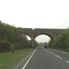
Angarrack Viaduct is a railway bridge in Angarrack featuring eleven granite arches that span across the valley below. The structure measures approximately 240 meters long and around 30 meters high, carrying the Cornish Main Line between the surrounding communities.

History

The original viaduct was designed by Isambard Kingdom Brunel as a timber structure for the West Cornwall Railway. It was replaced in 1888 with the current stone structure to provide greater durability and safety for increasing rail traffic.

Culture

The structure shapes the local landscape and serves as a daily reminder of the 19th century railway culture that transformed this region. It is a place where travelers experience Victorian engineering heritage directly as they pass over the tracks.

Practical

You can view the viaduct from nearby public paths that follow the valley and offer several vantage points. The best time for photographs is during good lighting when the granite arches stand out clearly against the sky.

Did you know?

Stone from the original Brunel foundations was later recycled and incorporated into the sea wall at Penzance railway station. This practice of material reuse shows how Victorian engineers sustainably worked with their resources and repurposed building materials.

Location
Official opening
1888
GPS coordinates
50.19332,-5.38538
Latest update
December 14, 2025 11:20

AroundUs brings together thousands of curated places, local tips, and hidden gems, enriched daily by 60,000 contributors worldwide. Discover all places nearby (Hayle).

Around this place
The Bucket of Blood
United Kingdom

The Bucket of Blood

2.1 km
St Elwyn's Church, Hayle
United Kingdom

St Elwyn's Church, Hayle

2.6 km
Church of Saint Winnear
United Kingdom

Church of Saint Winnear

1.2 km
St Felicitas and St Piala's Church, Phillack
United Kingdom

St Felicitas and St Piala's Church, Phillack

2 km
Upton Towans
United Kingdom

Upton Towans

2.4 km
Hayle Harbour
United Kingdom

Hayle Harbour

2.5 km
Loggan's Mill
United Kingdom

Loggan's Mill

1.2 km
The Cornubia Tavern
United Kingdom

The Cornubia Tavern

1.8 km
The War Memorial
United Kingdom

The War Memorial

2.3 km
Milestone At Sw577386
United Kingdom

Milestone At Sw577386

922 m
National Explosives
United Kingdom

National Explosives

2.2 km
Milestone At Sw601391
United Kingdom

Milestone At Sw601391

2 km
Carnsew Gallery
United Kingdom

Carnsew Gallery

2.7 km
Milestone At Sw564378
United Kingdom

Milestone At Sw564378

2 km
Milestone At Sw587384
United Kingdom

Milestone At Sw587384

410 m
Churchyard Wall Parallel To North Of Church And Gateways North Of Church Of Saint Winnear
United Kingdom

Churchyard Wall Parallel To North Of Church And Gateways North Of Church Of Saint Winnear

1.2 km
Cross At Approximately 4 Metres South West Of Tower
United Kingdom

Cross At Approximately 4 Metres South West Of Tower

2 km
Cross At Approximately 6 Metres North Of Church Of Saint Winnear
United Kingdom

Cross At Approximately 6 Metres North Of Church Of Saint Winnear

1.2 km
Bridge And Boundary Stone At Sw5687 3830
United Kingdom

Bridge And Boundary Stone At Sw5687 3830

1.6 km
Cross At Approximately 15 Metres North Of Tower Of Church Of Saint Winnear
United Kingdom

Cross At Approximately 15 Metres North Of Tower Of Church Of Saint Winnear

1.2 km
Footbridge At Sw 566361
United Kingdom

Footbridge At Sw 566361

2.7 km
Milestone At Roseworthy Hill On Former A30
United Kingdom

Milestone At Roseworthy Hill On Former A30

2.7 km
Milestone At Sw 57339 37649
United Kingdom

Milestone At Sw 57339 37649

1.2 km
Milestone At Connor Downs
United Kingdom

Milestone At Connor Downs

1.4 km
Doorway At Approximately 20 Metres South East Of Church Of Saint Winnear
United Kingdom

Doorway At Approximately 20 Metres South East Of Church Of Saint Winnear

1.3 km
The Passmore Edwards Institute
United Kingdom

The Passmore Edwards Institute

2.4 km
Guilford viaduct
United Kingdom

Guilford viaduct

986 m
Milestone Of Sw559370 In Garden Wall Of No.3
United Kingdom

Milestone Of Sw559370 In Garden Wall Of No.3

2.7 km
Show the full map
« Angarrack Viaduct - Railway viaduct in Angarrack, Cornwall, England » is provided by Around Us (aroundus.com). Images and texts are derived from Wikimedia project under a Creative Commons license. You are allowed to copy, distribute, and modify copies of this page, under the conditions set by the license, as long as this note is clearly visible.

Discover hidden gems everywhere you go!

From secret cafés to breathtaking viewpoints, skip the crowded tourist spots and find places that match your style. Our app makes it easy with voice search, smart filtering, route optimization, and insider tips from travelers worldwide. Download now for the complete mobile experience.

Around Us App Screenshot

A unique approach to discovering new places

Le Figaro

All the places worth exploring

France Info

A tailor-made excursion in just a few clicks

20 Minutes

Around Us
Travel Guide & Maps
Download

Send to your phone

QR Code
1

Open the camera app on your mobile.

2

Point at the QR code with your camera. A notification will appear.

3

Tap the notification to open the link.