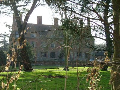
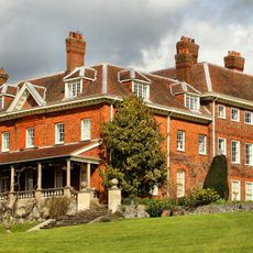
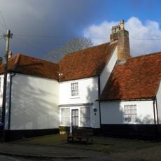
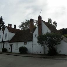
Aston Bury, Manor house in Aston, England.
Aston Bury is a manor house in England with a rectangular form and two storeys. Its flint and brick walls, timber framing, and steep roof covered in red tiles create its distinctive appearance.
The property was originally owned by the monks of St Mary Reading until the Crown seized it during the Dissolution of the Monasteries in the 16th century. This shift changed the building's purpose fundamentally.
The building shows construction techniques from the mid-17th century, combining flint bands, brick dressings, and timber-framed walls in a way that was typical for wealthy homes of that era. These methods are still visible in its appearance today.
The Grade I listed building is now a residential property with eleven separate luxury apartments and is not open to the public. Visitors can view the building from the outside and see its architectural details from the street.
The building features two prominent gabled stair wings at the rear, an unusual feature for a manor house of that period. These additions distinguish it noticeably from typical designs of the same era.
Location: Aston
GPS coordinates: 51.87900,-0.14800
Latest update: December 12, 2025 16:42
Benington Castle
2.8 km
The Tilbury
3.4 km
Church of St Martin
2.8 km
Benington High Wood
2 km
Parish Church of St Mary the Virgin
1 km
Church of Saint Mary
2.3 km
Church of All Saints
2.5 km
Parish Church of St Peter, Benington
2.8 km
War Memorial on St Mary's Churchyard (70 Metres to East of Church)
1 km
The Pig And Whistle Public House
1.1 km
Whomerley Wood moated site
3.5 km
George And Dragon Public House
3.5 km
The Bull Public House
3.6 km
Waggon And Horses Public House
2.9 km
The Roebuck Hotel
3 km
The Bell Public House
3 km
Datchworth War Memorial
2.6 km
Village Pump And Housing
3.4 km
Benington Lordship
2.9 km
Lych Gate At St Peter's Church (100 Metres To East North East Of Chancel)
3 km
Broadwater Farmhouse
3 km
93 And 95, High Street
3.5 km
Watton Place And Attached Garden Wall
3.3 km
Milepost At Junction With Station Road
2.8 km
Milestone, immediate NW of The Three Horseshoes PH
913 m
Milepost, half mile S of "Roebuck" PH
2.9 km
Milestone, Hertford Road at jct with Watton Road
1.4 km
Milestone, Hertford Road, Broadwater
2.7 kmVisited this place? Tap the stars to rate it and share your experience / photos with the community! Try now! You can cancel it anytime.
Discover hidden gems everywhere you go!
From secret cafés to breathtaking viewpoints, skip the crowded tourist spots and find places that match your style. Our app makes it easy with voice search, smart filtering, route optimization, and insider tips from travelers worldwide. Download now for the complete mobile experience.
A unique approach to discovering new places❞
— Le Figaro
All the places worth exploring❞
— France Info
A tailor-made excursion in just a few clicks❞
— 20 Minutes