Bishopton Castle, Medieval fortress in Bishopton, England
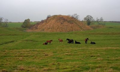
Bishopton Castle is a motte-and-bailey fortification located in a field about 400 meters southeast of Bishopton village. The site preserves a raised earthen mound and two adjoining defensive enclosures that show the typical two-part layout of Norman military construction.
Roger de Conyers built this fortification in 1143 during a dispute with William Cumin over control of the Durham bishopric. The castle emerged from a period of local power struggles in northern England.
The castle design reflects medieval English military architecture, demonstrating the power structure between local nobles and religious authorities.
The site is freely accessible and can be reached on foot from the village. The uneven ground and open field setting mean sturdy shoes and clear weather make visiting more comfortable.
Core samples taken during archaeological investigation in 2015 revealed that the mound was built directly by the Normans without being constructed on top of earlier earthwork foundations. This finding distinguished it from many other motte structures in the region.
Location: Bishopton
GPS coordinates: 54.58200,-1.43404
Latest update: December 9, 2025 20:25
Wynyard Park
7.2 km
Brick Train
7.7 km
Ropner Park
7.1 km
Church of St Andrew
7.7 km
St Peter's Church, Stockton-on-Tees
7.7 km
St Cuthbert's Church, Redmarshall
2 km
St Mary's Church, Norton
7.7 km
St Peter's Church, Bishopton
377 m
St Mary's Church, Longnewton
4.7 km
Church of St John the Baptist
5 km
Church of St Andrew
4.8 km
Church of All Saints
3.4 km
St John the Divine Church
2.9 km
Mill Bridge
7.6 km
Bishopton War Memorial
417 m
United Reformed Church of St Andrew and St George
7.8 km
Norton East Signal Box
6.7 km
Little Burdon Farmhouse
5.9 km
Barmpton, Great Burdon and Haughton-le-Skerne War Memorial
7.7 km
Hall Garth
7.6 km
Sedgefield House
7.9 km
Ketton Bridge
6.6 km
The Stables Bar And Restaurant, Front Wall And Piers To East Of Hall Garth
7.6 km
Milepost And Milestone 15 Metres West Of Number 2
6.6 km
Remains of village cross 15 metres west of Church of St Peter
385 m
Manor Farmhouse
2.4 km
Milestone, roadside at NZ380163
4.8 km
10, West End
7.9 kmVisited this place? Tap the stars to rate it and share your experience / photos with the community! Try now! You can cancel it anytime.
Discover hidden gems everywhere you go!
From secret cafés to breathtaking viewpoints, skip the crowded tourist spots and find places that match your style. Our app makes it easy with voice search, smart filtering, route optimization, and insider tips from travelers worldwide. Download now for the complete mobile experience.
A unique approach to discovering new places❞
— Le Figaro
All the places worth exploring❞
— France Info
A tailor-made excursion in just a few clicks❞
— 20 Minutes