Bussock Camp

Log in to your account

AroundUs is a community-driven map of interesting places, built by curious explorers like you. It grows with every review, story, and photo you share.
Connect to save your favorite spots, contribute locations, and create personalized routes.
By continuing, you accept our Terms and Conditions and our Privacy Policy
Add to collection
Map
Suggest a change
Share

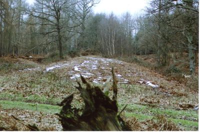
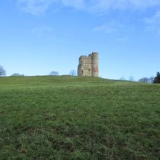
Bussock Camp, Iron Age contour fort in Chieveley, England
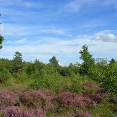
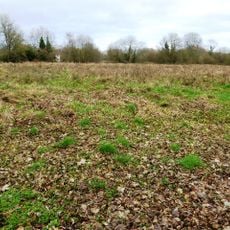
The ancient fortification features a double bank and ditch system on its southern and eastern sides, while single banks remain on the north and west.

The fort, constructed in the 6th century BC, provided shelter and defense for approximately 300 ancient Britons across multiple generations.

The archaeological site reveals patterns of early British settlements and their defensive strategies through preserved structural elements and artifacts.

Situated within private grounds at coordinates 51.4489068, -1.3291496, the fort becomes accessible to visitors during bluebell season in May.

The fort encompasses 11 acres of land with its original entrance positioned strategically on the northern side of the enclosure.

Location: Chieveley

GPS coordinates: 51.44891,-1.32915

Latest update: March 8, 2025 19:44

Around this place
Show the full map
Donnington Castle
United Kingdom

Donnington Castle

3.3 km
Watermill Theatre
United Kingdom

Watermill Theatre

3.5 km
Shaw House
United Kingdom

Shaw House

4.2 km
Snelsmore Common
United Kingdom

Snelsmore Common

1.6 km
Donnington Hospital
United Kingdom

Donnington Hospital

3.8 km
Boxford Water Meadows
United Kingdom

Boxford Water Meadows

3.9 km
Church of St Bartholomew
United Kingdom

Church of St Bartholomew

4.1 km
Parish Church of St Andrew
United Kingdom

Parish Church of St Andrew

3.9 km
Church of St James
United Kingdom

Church of St James

1.7 km
Church of St Mary
United Kingdom

Church of St Mary

1.8 km
Parish Church of St Mary
United Kingdom

Parish Church of St Mary

4.2 km
Priors Court School
United Kingdom

Priors Court School

2.5 km
Gates, Overthrow And Gatepiers Approximately 80 Metres To South Of Shaw House School
United Kingdom

Gates, Overthrow And Gatepiers Approximately 80 Metres To South Of Shaw House School

4.2 km
Speen War Memorial
United Kingdom

Speen War Memorial

4.5 km
Tomb Approximately 2 Yards East Of Chancel Of St Andrews Church
United Kingdom

Tomb Approximately 2 Yards East Of Chancel Of St Andrews Church

3.9 km
Group Of 3 Chest Tombs Approximately 14 Metres To South Of Nave Of Church Of St Mary
United Kingdom

Group Of 3 Chest Tombs Approximately 14 Metres To South Of Nave Of Church Of St Mary

4.2 km
Eassell Tomb Approximately 2 Yards To East Of Chancel Of St Andrews Church
United Kingdom

Eassell Tomb Approximately 2 Yards To East Of Chancel Of St Andrews Church

3.9 km
2 and 3, Hillside Cottages, Bath Road
United Kingdom

2 and 3, Hillside Cottages, Bath Road

4.4 km
The Priory
United Kingdom

The Priory

3.8 km
The Vicarage
United Kingdom

The Vicarage

1.9 km
Primary School And Schoolmaster's House
United Kingdom

Primary School And Schoolmaster's House

3.8 km
Lychgate And Flanking Walls Approximately 15 Metres To South Of Church Of St Mary
United Kingdom

Lychgate And Flanking Walls Approximately 15 Metres To South Of Church Of St Mary

4.2 km
Milestone Approximately 30 Metres To South Of Donnington Hospital
United Kingdom

Milestone Approximately 30 Metres To South Of Donnington Hospital

3.9 km
Tonayne House And Coach House Adjoining To North
United Kingdom

Tonayne House And Coach House Adjoining To North

3.8 km
Donnington Castle: a quadrangular castle and 17th century fieldwork.
United Kingdom

Donnington Castle: a quadrangular castle and 17th century fieldwork.

3.4 km
Milestone, Downend; opp Wellsley, 100m N of jct of road to Downend
United Kingdom

Milestone, Downend; opp Wellsley, 100m N of jct of road to Downend

3 km
1, Castle Lane
United Kingdom

1, Castle Lane

3.6 km
Milestone, opp. Fox & Hounds PH just S of by-pass bridge
United Kingdom

Milestone, opp. Fox & Hounds PH just S of by-pass bridge

1.9 km
Show the full map

Reviews

Visited this place? Tap the stars to rate it and share your experience / photos with the community! Try now! You can cancel it anytime.

« Bussock Camp - Iron Age contour fort in Chieveley, England » is provided by Around Us (aroundus.com). Images and texts are derived from Wikimedia project under a Creative Commons license. You are allowed to copy, distribute, and modify copies of this page, under the conditions set by the license, as long as this note is clearly visible.

Discover hidden gems everywhere you go!

From secret cafés to breathtaking viewpoints, skip the crowded tourist spots and find places that match your style. Our app makes it easy with voice search, smart filtering, route optimization, and insider tips from travelers worldwide. Download now for the complete mobile experience.

Around Us App Screenshot

A unique approach to discovering new places

Le Figaro

All the places worth exploring

France Info

A tailor-made excursion in just a few clicks

20 Minutes