Snelsmore Common, Nature reserve and wildlife sanctuary in North Wessex Downs, England.
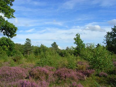
Snelsmore Common is a nature reserve with many different habitats: dry heathland, wet heathland, boggy areas, birch woodlands, and ancient broadleaved forest. Each habitat type supports different plants and creatures.
The bog area preserves a peat layer that is 5,000 years old, recording shifts in plant life and how people used the land over time. These layers of peat tell the story of environmental change across millennia.
This place was once shared common land where people gathered firewood and let their animals graze, a practice central to English village life. The way people used the land shaped which plants and habitats exist here today.
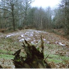
Multiple walking routes cross the reserve, including a paved trail designed for easier access. Free parking is available, making it simple to start exploring the different areas.
The wet alder woodlands here host unusual lichen communities that thrive nowhere else easily. These slow-growing organisms are signs of an undisturbed forest environment.
GPS coordinates: 51.43610,-1.33960
Latest update: December 13, 2025 11:47
Donnington Castle
1.8 km
Watermill Theatre
1.9 km
Shaw House
3.1 km
Bussock Camp
1.6 km
Donnington Hospital
2.5 km
Parish Church of St Andrew
3.2 km
Church of St James
1.3 km
Parish Church of St Mary
3.1 km
Parish Church of St Mary
3.2 km
Gates, Overthrow And Gatepiers Approximately 80 Metres To South Of Shaw House School
3.1 km
Speen War Memorial
2.9 km
Alma Cottage Alma Lodge
2.9 km
Group Of 3 Chest Tombs Approximately 14 Metres To South Of Nave Of Church Of St Mary
3.1 km
Tomb Approximately 2 Yards East Of Chancel Of St Andrews Church
3.2 km
2 and 3, Hillside Cottages, Bath Road
2.8 km
Granary At Speen Farm
3 km
Eassell Tomb Approximately 2 Yards To East Of Chancel Of St Andrews Church
3.2 km
The Priory
2.5 km
Castle Houses
3.3 km
Donnington Castle: a quadrangular castle and 17th century fieldwork.
1.9 km
Primary School And Schoolmaster's House
2.5 km
Tonayne House And Coach House Adjoining To North
2.4 km
Milestone On Bath Road In Speen Opposite Speen Manor
3 km
Lychgate And Flanking Walls Approximately 15 Metres To South Of Church Of St Mary
3.1 km
Milestone Approximately 30 Metres To South Of Donnington Hospital
2.5 km
Rectory Farmhouse
2.9 km
Milestone, opp. Fox & Hounds PH just S of by-pass bridge
1.1 km
1, Castle Lane
2.2 kmVisited this place? Tap the stars to rate it and share your experience / photos with the community! Try now! You can cancel it anytime.
Discover hidden gems everywhere you go!
From secret cafés to breathtaking viewpoints, skip the crowded tourist spots and find places that match your style. Our app makes it easy with voice search, smart filtering, route optimization, and insider tips from travelers worldwide. Download now for the complete mobile experience.
A unique approach to discovering new places❞
— Le Figaro
All the places worth exploring❞
— France Info
A tailor-made excursion in just a few clicks❞
— 20 Minutes