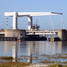
Breydon Water, Protected wetland estuary in Norfolk, Great Britain
Breydon Water is a large protected wetland on the Norfolk coast shaped by wide mudflats and salt marshes. The waters connect two major marshland systems and reveal a completely different landscape between high and low tide.
The site began as a large open estuary that transformed gradually over centuries through natural processes. Two major rivers converge at the western end, a meeting point that has shaped the water system into what visitors see today.
The name reflects the broad waters that have shaped local life for centuries, with fishing and bird watching deeply rooted in how people interact with the estuary. You can see this connection today in the way visitors and residents move through the area, always watching the sky and water.
The area is best explored by paying attention to tides and understanding when water levels shift dramatically. With the right information about high and low tide times, visitors can safely navigate the landscape and grasp how the place constantly changes.
The site hosts a remarkable gathering of migratory birds during winter months that travel from distant regions. This seasonal shift in bird populations creates a different experience with each visit depending on the time of year.
The community of curious travelers
AroundUs brings together thousands of curated places, local tips, and hidden gems, enriched daily by 60,000 contributors worldwide.