Enable Location

We need your location to show you interesting places around you

Discover nearby places

Find interesting locations and hidden gems around you

Precise directions

Get accurate directions and distances to places

Your location is never shared with other users. It's only used when you tap the location button.

Causeway Coast and Glens

Log in to your account

Start exploring — it's free

Trusted by 63,231 travelers worldwide

Continue with Google
Continue with Apple
or

We will send you a code to connect

By continuing, you accept our Terms and Conditions and our Privacy Policy

Check your inbox

We've sent a pincode in your inbox. Please enter the code below.

Discussion Reviews 1 Photos
10.3k Popularity

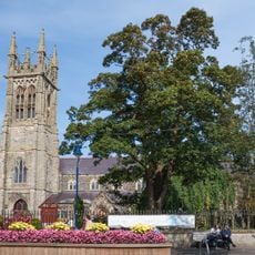
Causeway Coast and Glens, Protected coastal area in County Antrim, Northern Ireland.

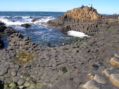
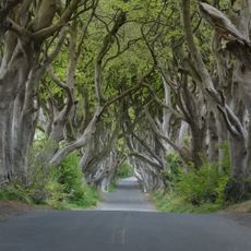
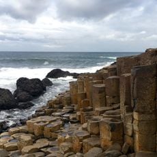
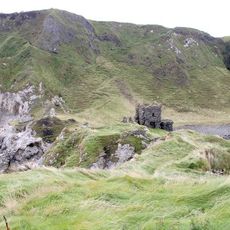
The Causeway Coast and Glens stretch approximately 30 kilometers along the North Antrim coast, featuring alternating white chalk cliffs and dark basalt formations. The region contains nine distinct valleys interwoven with walking paths and multiple entry points for exploration.

The area received official recognition as an Area of Outstanding Natural Beauty in 1988 through the Nature Conservation and Amenity Lands Order. This designation came to protect the coast and its geological formations for future generations.

The nine glens throughout the region host traditional Irish music sessions and local craft demonstrations that continue year-round. Visitors can experience these cultural activities in the villages and meet people who keep these traditions alive.

The coastal walking paths are accessible from several starting points, allowing visitors to explore at different difficulty levels. Regular bus services connect the major attractions from the town of Coleraine, making access straightforward.

Rathlin Island lies within the protected area and houses Northern Ireland's largest seabird colony, including puffins, razorbills, and kittiwakes. The island represents one of the region's most valuable wildlife sanctuaries for bird watchers.

The community of curious travelers

AroundUs brings together thousands of curated places, local tips, and hidden gems, enriched daily by 60,000 contributors worldwide.

Start exploring
Location
Capital city
Coleraine
GPS coordinates
55.20300,-6.50000
Latest update
December 10, 2025 15:55
Around this place
Dark Hedges
United Kingdom

Dark Hedges

10.8 km
Royal Portrush Golf Club
United Kingdom

Royal Portrush Golf Club

8.2 km
Carrick-a-Rede Rope Bridge
United Kingdom

Carrick-a-Rede Rope Bridge

11.4 km
Giant's Causeway
United Kingdom

Giant's Causeway

4.3 km
Dunseverick Castle
United Kingdom

Dunseverick Castle

5 km
Kinbane Castle
United Kingdom

Kinbane Castle

13.6 km
Giant's Causeway and Bushmills Railway
United Kingdom

Giant's Causeway and Bushmills Railway

2.4 km
Dundarave House
United Kingdom

Dundarave House

1.1 km
White Park Bay
United Kingdom

White Park Bay

6.9 km
Ballintoy Parish Church
United Kingdom

Ballintoy Parish Church

9.4 km
Bann Bridge
United Kingdom

Bann Bridge

13 km
Town Hall The Diamond Coleraine Co.londonderry
United Kingdom

Town Hall The Diamond Coleraine Co.londonderry

13.5 km
Portrush Town Hall
United Kingdom

Portrush Town Hall

9.7 km
Portstewart Town Hall
United Kingdom

Portstewart Town Hall

14.1 km
Ballymoney Town Hall
United Kingdom

Ballymoney Town Hall

14.7 km
Craig Hill
United Kingdom

Craig Hill

1.8 km
Armoy Round Tower and Church
United Kingdom

Armoy Round Tower and Church

14.2 km
St. John's R C Church Kyle's Brae Coleraine Co.londonderry
United Kingdom

St. John's R C Church Kyle's Brae Coleraine Co.londonderry

14.1 km
Ballymoney Museum
United Kingdom

Ballymoney Museum

14.7 km
St Olcan's RC Church
United Kingdom

St Olcan's RC Church

14.7 km
Methodist Church Circular Road Coleraine Co.londonderry
United Kingdom

Methodist Church Circular Road Coleraine Co.londonderry

13.5 km
St. Patrick's Church, Coleraine, Northern Ireland
United Kingdom

St. Patrick's Church, Coleraine, Northern Ireland

13.3 km
Billy C Of I Parish Church 1 Cabragh Road Glebe Td Bushmills Co. Antrim Bt57 8ud
United Kingdom

Billy C Of I Parish Church 1 Cabragh Road Glebe Td Bushmills Co. Antrim Bt57 8ud

2.4 km
Holy Trinity Parish Church, Main St. Portrush
United Kingdom

Holy Trinity Parish Church, Main St. Portrush

9.7 km
39-39B Castle Street Ballycastle
United Kingdom

39-39B Castle Street Ballycastle

15.5 km
Our Lady And St. Patrick R C Church Castle St. Ballymoney Co.antrim
United Kingdom

Our Lady And St. Patrick R C Church Castle St. Ballymoney Co.antrim

15.2 km
Presbyterian Church Church St./enfield St. Portstewart Co.londonderry
United Kingdom

Presbyterian Church Church St./enfield St. Portstewart Co.londonderry

14 km
70 Castle Street Ballycastle
United Kingdom

70 Castle Street Ballycastle

15.6 km
Show the full map
Reviews
Share your experience

No review yet

Discussions
Start a discussion...

No discussion yet

« Causeway Coast and Glens - Protected coastal area in County Antrim, Northern Ireland » is provided by Around Us (aroundus.com). Images and texts are derived from Wikimedia project under a Creative Commons license. You are allowed to copy, distribute, and modify copies of this page, under the conditions set by the license, as long as this note is clearly visible.

Discover hidden gems everywhere you go!

From secret cafés to breathtaking viewpoints, skip the crowded tourist spots and find places that match your style. Our app makes it easy with voice search, smart filtering, route optimization, and insider tips from travelers worldwide. Download now for the complete mobile experience.

Around Us App Screenshot

A unique approach to discovering new places

Le Figaro

All the places worth exploring

France Info

A tailor-made excursion in just a few clicks

20 Minutes

Around Us
Travel Guide & Maps
Download

Send to your phone

QR Code
1

Open the camera app on your mobile.

2

Point at the QR code with your camera. A notification will appear.

3

Tap the notification to open the link.