Christ Church, North Shields

Log in to your account

AroundUs is a community-driven map of interesting places, built by curious explorers like you. It grows with every review, story, and photo you share.
Connect to save your favorite spots, contribute locations, and create personalized routes.
Continue with Google
Continue with Apple
Continue with X
Continue with Facebook
Continue with email
By continuing, you accept our Terms and Conditions and our Privacy Policy
Create an account

Christ Church, North Shields

Add to collection
Map
Suggest a change
Share

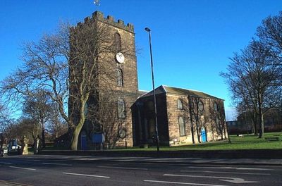
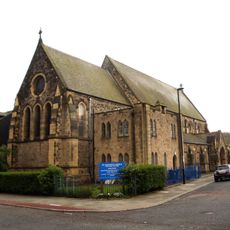
Christ Church, North Shields, Grade II listed Anglican church in North Shields, England.

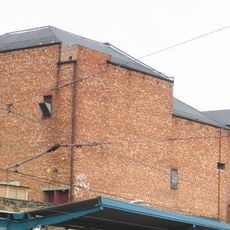
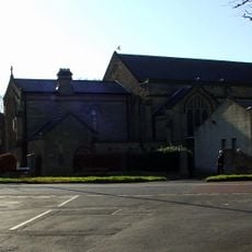
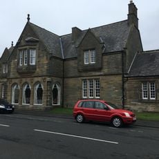
Christ Church is a sandstone building in Georgian style featuring a three-story western tower topped with battlements and decorated with round windows and round-headed openings. The structure combines a substantial nave with this distinctive tower element that defines the local streetscape.

Robert Trollope designed the original structure in 1663, while John Dodds added the western tower between 1786 and 1788 and remodeled the building from 1792 onward. These building phases show how the church expanded and renewed itself across several generations.

The interior shows elliptical arches held up by Tuscan columns, with a western gallery containing the organ and monuments honoring vicar Stephen Dockwray. These elements reflect how the community has marked important figures from its past.

The church sits on Preston Road with parking available nearby and offers level access to the main areas inside. Walkers and cyclists can reach and navigate the grounds with ease.

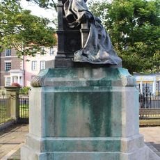
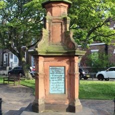
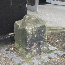
The churchyard contains a listed chest tomb for Edward Hodgson, a shoemaker from North Shields who helped establish the church in 1690. This stone grave preserves the memory of a local figure whose efforts shaped the creation of this place.

Location: North Shields

Location: North Tyneside

Inception: 1793

Architects: Robert Trollope

Architectural style: Georgian architecture

Website: http://northshieldsparish.org/Church.htm

GPS coordinates: 55.01145,-1.44810

Latest update: December 13, 2025 12:21

Photos
Around this place
Arbeia South Shields Roman Fort
United Kingdom

Arbeia South Shields Roman Fort

1.3 km
Tyne Turrets
United Kingdom

Tyne Turrets

1.4 km
Clifford's Fort
United Kingdom

Clifford's Fort

951 m
Tynemouth Town Hall
United Kingdom

Tynemouth Town Hall

399 m
Arbeia, South Shields Roman Fort
United Kingdom

Arbeia, South Shields Roman Fort

1.3 km
Herd Groyne Light
United Kingdom

Herd Groyne Light

1.5 km
Fish Quay Old Low Light
United Kingdom

Fish Quay Old Low Light

962 m
Fish Quay New Lighthouses
United Kingdom

Fish Quay New Lighthouses

718 m
Old Lowlight Heritage Centre
United Kingdom

Old Lowlight Heritage Centre

935 m
Fish Quay Old High Light
United Kingdom

Fish Quay Old High Light

759 m
Fish Quay High Light
United Kingdom

Fish Quay High Light

718 m
Fish Quay Low Light
United Kingdom

Fish Quay Low Light

905 m
New Princes Theatre
United Kingdom

New Princes Theatre

319 m
Church of Holy Saviour
United Kingdom

Church of Holy Saviour

1.4 km
Statue of Queen Victoria
United Kingdom

Statue of Queen Victoria

1.6 km
Statue of Duke of Northumberland, South of Master Mariners' Homes
United Kingdom

Statue of Duke of Northumberland, South of Master Mariners' Homes

1.1 km
Church of St Augustin
United Kingdom

Church of St Augustin

718 m
South African War Memorial Opposite Number 2
United Kingdom

South African War Memorial Opposite Number 2

1.5 km
First World War Memorial Opposite Number 6
United Kingdom

First World War Memorial Opposite Number 6

1.6 km
Master Mariners' Homes
United Kingdom

Master Mariners' Homes

1.1 km
Piers And Walls To West And South Of Christ Church
United Kingdom

Piers And Walls To West And South Of Christ Church

30 m
Clifford's Fort  Trinity House Almshouses And Boundary Stone Attached
United Kingdom

Clifford's Fort Trinity House Almshouses And Boundary Stone Attached

936 m
Main Passenger Building Of Tynemouth Old Railway Station
United Kingdom

Main Passenger Building Of Tynemouth Old Railway Station

1.5 km
1, Howard Street
United Kingdom

1, Howard Street

584 m
1-3, Tynemouth Terrace
United Kingdom

1-3, Tynemouth Terrace

1.6 km
Ballard's Smoke House  Clifford's Fort And Boundary Stones Attached
United Kingdom

Ballard's Smoke House Clifford's Fort And Boundary Stones Attached

966 m
Clifford's Fort South And East Wall Facing River
United Kingdom

Clifford's Fort South And East Wall Facing River

977 m
Milestone, North Shields, Albion Road, by Christ Church churchyard entrance
United Kingdom

Milestone, North Shields, Albion Road, by Christ Church churchyard entrance

66 m
Show the full map
Reviews

Visited this place? Tap the stars to rate it and share your experience / photos with the community! Try now! You can cancel it anytime.

« Christ Church, North Shields - Grade II listed Anglican church in North Shields, England » is provided by Around Us (aroundus.com). Images and texts are derived from Wikimedia project under a Creative Commons license. You are allowed to copy, distribute, and modify copies of this page, under the conditions set by the license, as long as this note is clearly visible.

Discover hidden gems everywhere you go!

From secret cafés to breathtaking viewpoints, skip the crowded tourist spots and find places that match your style. Our app makes it easy with voice search, smart filtering, route optimization, and insider tips from travelers worldwide. Download now for the complete mobile experience.

Around Us App Screenshot

A unique approach to discovering new places

Le Figaro

All the places worth exploring

France Info

A tailor-made excursion in just a few clicks

20 Minutes