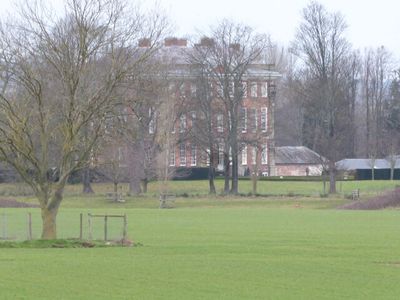
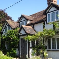
Cound Hall, Baroque country house in Cound, England.
Cound Hall is a Baroque country house built with red brick featuring tall, slender windows across two main floors. Stone decorations and fluted Corinthian pilasters accent the exterior, giving the structure a formal and refined appearance.
Edward Cressett commissioned architect John Prince of Shrewsbury to build this grand house between 1703 and 1704. The structure was created as an ambitious country residence reflecting early 18th-century English tastes.
The house displays architectural influences from Greenwich Hospital, with large-scale pilasters and carved capitals adorning its main facades. These elements shaped how the residence presented itself as a statement of wealth and refined taste.
The house sits along the A458 road, making it accessible by car. After standing vacant for 15 years, it was thoroughly restored in 1996 and returned to good condition.
Romance novelist Barbara Cartland lived in this house during the early 1930s while married to Alexander McCorquodale. Her residence here connects the place to 20th-century literary history.
Location: Cound
Architectural style: Baroque
GPS coordinates: 52.64390,-2.65083
Latest update: December 13, 2025 11:45
Pitchford Hall
3.5 km
Acton Burnell Castle
4.3 km
Cronkhill
3.9 km
St Andrew's Church, Wroxeter
2.9 km
St Eata's Church, Atcham
4.3 km
St Peter's Church, Cound
408 m
Acton Burnell Hall
4.2 km
All Saints Church, Berrington
3.4 km
Church of St Mary
3.8 km
Church of St Michael
3.5 km
The Eagles Inn
3.3 km
The Old Post Office
3 km
Village Pump And Trough Approximately 10 Metres To South Of Numbers 66 And 72
3.9 km
Cound War Memorial
525 m
Cressage War Memorial
3.3 km
Milestone Approximately 40 Metres To The South Of Milestone Cottage
4.2 km
Milestone Approximately 100 Metres To North Of Harnage Grange
3.1 km
Ice House Approximately 200 Metres To North West Of Lower Eyton
1.1 km
Milestone Approximately 60 Metres To West Of Harnage House
989 m
Cound Arbour Bridge
538 m
Keepers Lodge
4.1 km
Tern Lodge And Adjoining Wall
4.1 km
Milepost Approximately 50 Metres To North Of Number 39, Venusbank
922 m
Site of Roman town of Wroxeter (Viroconium)
3.5 km
Milepost At Ngr Sj 5836 0452
2.4 km
Milestone Approximately 70 Metres To East Of North Lodge
3.3 km
Churchyard gates, gate piers and approximately 3 metres of flanking walls approximately 10 metres to west of west tower of Church of St Andrew
2.9 km
Milestone, 260m NW Wroxeter crossroads
3.7 kmVisited this place? Tap the stars to rate it and share your experience / photos with the community! Try now! You can cancel it anytime.
Discover hidden gems everywhere you go!
From secret cafés to breathtaking viewpoints, skip the crowded tourist spots and find places that match your style. Our app makes it easy with voice search, smart filtering, route optimization, and insider tips from travelers worldwide. Download now for the complete mobile experience.
A unique approach to discovering new places❞
— Le Figaro
All the places worth exploring❞
— France Info
A tailor-made excursion in just a few clicks❞
— 20 Minutes