Enable Location

We need your location to show you interesting places around you

Discover nearby places

Find interesting locations and hidden gems around you

Precise directions

Get accurate directions and distances to places

Your location is never shared with other users. It's only used when you tap the location button.

Donaghadee lighthouse

Log in to your account

Start exploring — it's free

Trusted by 62,484 travelers worldwide

Continue with Google
Continue with Apple
or

We will send you a code to connect

By continuing, you accept our Terms and Conditions and our Privacy Policy

Check your inbox

We've sent a pincode in your inbox. Please enter the code below.

Donaghadee lighthouse

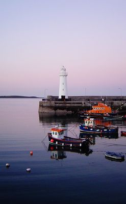
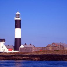
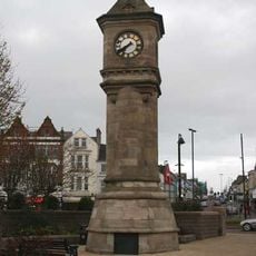
Donaghadee lighthouse, lighthouse in Northern Ireland

Donaghadee lighthouse is a white stone structure built from cut limestone in 1836 and stands about 16 meters tall. It sits on a small headland at the harbor entrance and has a lantern and dome at the top that are maintained today.

The lighthouse was built in 1836 to protect ships from rocky coasts and support a route between Donaghadee and the Scottish port of Portpatrick. In 1934 it became Ireland's first lighthouse to convert fully to electric power, later gaining automatic systems and backup generators to ensure operation.

The name Donaghadee comes from Irish and means 'fortress of the dog'. The village keeps its maritime tradition alive today, with active fishermen and a lifeboat station right beside the lighthouse, showing how important seafaring and safety remain to the community.

The lighthouse is open to visitors, and on some days you can go inside to see how it was built and how the mechanisms work. Climbing the tower offers views of the coastline and town, best experienced in dry weather.

The lighthouse was the first light in all of Ireland to switch fully to electric lighting in 1934, making it a pioneer in Irish maritime technology. This technological leap showed how innovative this small harbor community was at that time.

The community of curious travelers

AroundUs brings together thousands of curated places, local tips, and hidden gems, enriched daily by 60,000 contributors worldwide.

Start exploring
Location
Inception
1836
GPS coordinates
54.64505,-5.53092
Latest update
February 9, 2026 07:40
Around this place
Mount Stewart
United Kingdom

Mount Stewart

11.2 km
Clandeboye Estate
United Kingdom

Clandeboye Estate

12 km
Bangor Abbey
United Kingdom

Bangor Abbey

9.4 km
Helen's Tower
United Kingdom

Helen's Tower

10.8 km
Bangor Castle
United Kingdom

Bangor Castle

9 km
Movilla Abbey
United Kingdom

Movilla Abbey

11.7 km
Grey Abbey
United Kingdom

Grey Abbey

12.3 km
Mew Island Lighthouse
United Kingdom

Mew Island Lighthouse

5.8 km
Ballycopeland Windmill
United Kingdom

Ballycopeland Windmill

4.4 km
Ward Park
United Kingdom

Ward Park

8.5 km
Pickie Fun Park
United Kingdom

Pickie Fun Park

9.5 km
McKee Clock
United Kingdom

McKee Clock

9.1 km
Town Hall Conway Square Newtownards Co. Down
United Kingdom

Town Hall Conway Square Newtownards Co. Down

12.1 km
Newtownards Priory
United Kingdom

Newtownards Priory

12 km
Former Town Hall 24 High Street Donaghadee Co Down
United Kingdom

Former Town Hall 24 High Street Donaghadee Co Down

500 m
Bangor Town Museum
United Kingdom

Bangor Town Museum

9 km
Somme Museum
United Kingdom

Somme Museum

10.3 km
First Presbyterian Church 100 Main Street Bangor Co Down Bt20 4ag
United Kingdom

First Presbyterian Church 100 Main Street Bangor Co Down Bt20 4ag

9.1 km
Bangor Carnegie Library
United Kingdom

Bangor Carnegie Library

8.6 km
Clandeboye House
United Kingdom

Clandeboye House

12 km
Donagahdee (cof I) Parish Church Church Place Donaghadee County Down Bt21 0db
United Kingdom

Donagahdee (cof I) Parish Church Church Place Donaghadee County Down Bt21 0db

625 m
Christ Church (c Of I) Woburn Road Ballyrawer Millisle Newtownards Co Down Bt22 2hy
United Kingdom

Christ Church (c Of I) Woburn Road Ballyrawer Millisle Newtownards Co Down Bt22 2hy

7 km
St. Saviourís C Of I Parish Church Church Street Greyabbey Newtownards Co. Down Bt22 2nq
United Kingdom

St. Saviourís C Of I Parish Church Church Street Greyabbey Newtownards Co. Down Bt22 2nq

12.1 km
Woburn House
United Kingdom

Woburn House

5.7 km
Mount Stewart & Garden Walls Mount Stewart Newtownards Co. Down Bt22 2ru
United Kingdom

Mount Stewart & Garden Walls Mount Stewart Newtownards Co. Down Bt22 2ru

11.4 km
St. Markís (c Of I) Parish Church Church Street Newtownards Co Down Bt23 4an
United Kingdom

St. Markís (c Of I) Parish Church Church Street Newtownards Co Down Bt23 4an

12.5 km
Town Hall Bangor Castle Castle Park Avenue Bangor Co Down Bt20 4bn
United Kingdom

Town Hall Bangor Castle Castle Park Avenue Bangor Co Down Bt20 4bn

9 km
Bangor War Memorial Ward Park Bangor Co Down
United Kingdom

Bangor War Memorial Ward Park Bangor Co Down

8.6 km
Show the full map
« Donaghadee lighthouse - lighthouse in Northern Ireland » is provided by Around Us (aroundus.com). Images and texts are derived from Wikimedia project under a Creative Commons license. You are allowed to copy, distribute, and modify copies of this page, under the conditions set by the license, as long as this note is clearly visible.

Discover hidden gems everywhere you go!

From secret cafés to breathtaking viewpoints, skip the crowded tourist spots and find places that match your style. Our app makes it easy with voice search, smart filtering, route optimization, and insider tips from travelers worldwide. Download now for the complete mobile experience.

Around Us App Screenshot

A unique approach to discovering new places

Le Figaro

All the places worth exploring

France Info

A tailor-made excursion in just a few clicks

20 Minutes

Around Us
Travel Guide & Maps
Download

Send to your phone

QR Code
1

Open the camera app on your mobile.

2

Point at the QR code with your camera. A notification will appear.

3

Tap the notification to open the link.