Enable Location

We need your location to show you interesting places around you

Discover nearby places

Find interesting locations and hidden gems around you

Precise directions

Get accurate directions and distances to places

Your location is never shared with other users. It's only used when you tap the location button.

Errwood Hall

Log in to your account

Start exploring — it's free

Trusted by 61,397 travelers worldwide

Continue with Google
Continue with Apple
or

We will send you a code to connect

By continuing, you accept our Terms and Conditions and our Privacy Policy

Check your inbox

We've sent a pincode in your inbox. Please enter the code below.

Errwood Hall

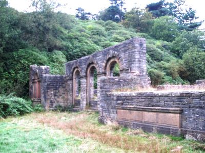
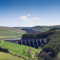
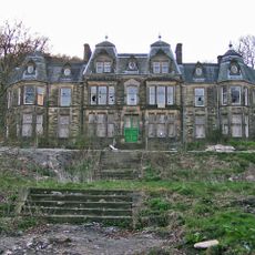
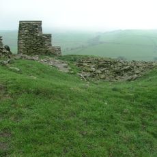
Errwood Hall, Victorian country house ruins in Peak District, Great Britain

Description

Errwood Hall is the site of a 19th-century country house that now remains as stone foundations and standing walls scattered across the Upper Goyt Valley, surrounded by woodland. The ruins show where rooms once stood and give a sense of the building's original scale.

History

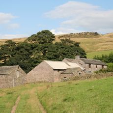
Samuel Grimshawe II, a wealthy Manchester businessman, built the hall in the 1830s as the focal point of a large rural estate with working farms and mining operations. The structure dominated the landscape for over a century until it was abandoned in the 20th century.

Culture

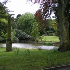
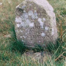
The Grimshawe family left personal marks on this place, including a private cemetery and a memorial shrine dedicated to their governess Miss Dolores de Ybarguen. These intimate spaces reflect how the family expressed their attachment to the estate.

Practical

The site is open to public access and can be explored freely, as protective barriers have been removed in recent years. Visitors should stay on marked paths and follow any safety guidance posted by the Peak Park Authority to ensure safe exploration.

Did you know?

An augmented reality app lets visitors see the hall as it once stood by overlaying digital reconstructions on the actual ruins in real time. This creates a striking contrast between what remains today and the building's former presence.

GPS coordinates
53.26950,-1.98725
Latest update
December 10, 2025 15:51

AroundUs brings together thousands of curated places, local tips, and hidden gems, enriched daily by 60,000 contributors worldwide. Discover all places nearby (United Kingdom).

Around this place
Errwood Reservoir
United Kingdom

Errwood Reservoir

922 m
Windgather Rocks
United Kingdom

Windgather Rocks

3.9 km
Fernilee Reservoir
United Kingdom

Fernilee Reservoir

2.2 km
Lamaload Reservoir
United Kingdom

Lamaload Reservoir

3.8 km
Jenkin Chapel
United Kingdom

Jenkin Chapel

3.2 km
Forest Chapel
United Kingdom

Forest Chapel

4.4 km
Christ Church
United Kingdom

Christ Church

3.9 km
Saltersford Hall And Attached Farm Buildings
United Kingdom

Saltersford Hall And Attached Farm Buildings

3 km
Wye House
United Kingdom

Wye House

4.6 km
3 obelisks within the gardens of Edgemoor (Edgemoor not included)
United Kingdom

3 obelisks within the gardens of Edgemoor (Edgemoor not included)

2.9 km
Milepost at SJ 9991 7211
United Kingdom

Milepost at SJ 9991 7211

2.8 km
Lightwood Ridge (Number 199) and Woodlea (Number 201)
United Kingdom

Lightwood Ridge (Number 199) and Woodlea (Number 201)

4.6 km
Summerclose Farmhouse and attached barn
United Kingdom

Summerclose Farmhouse and attached barn

4.3 km
Wayside shrine at SK 0070 7525
United Kingdom

Wayside shrine at SK 0070 7525

1.4 km
Longford Lodge
United Kingdom

Longford Lodge

4.4 km
Milestone 140 metres north of milepost at SJ 9991 7211
United Kingdom

Milestone 140 metres north of milepost at SJ 9991 7211

2.7 km
Manor House (Number 9) and Barton House (Number 11)
United Kingdom

Manor House (Number 9) and Barton House (Number 11)

4.6 km
Yearn's Low bowl barrow
United Kingdom

Yearn's Low bowl barrow

4.7 km
Walls and gates to Milnthorp Homes
United Kingdom

Walls and gates to Milnthorp Homes

4.5 km
Milepost at SJ 9681 7353
United Kingdom

Milepost at SJ 9681 7353

4.3 km
Milepost at SJ 9818 7347
United Kingdom

Milepost at SJ 9818 7347

3 km
Lismore Fields Mesolithic and Neolithic settlement
United Kingdom

Lismore Fields Mesolithic and Neolithic settlement

4.3 km
Milepost 4 Miles From Buxton, 7 3/4 From Macclesfield
United Kingdom

Milepost 4 Miles From Buxton, 7 3/4 From Macclesfield

3.6 km
Milestone, Axe Edge Moor, W of Ladmanlow
United Kingdom

Milestone, Axe Edge Moor, W of Ladmanlow

3.1 km
Milepost, beneath The Terett, W of Buxton
United Kingdom

Milepost, beneath The Terett, W of Buxton

3.6 km
Milepost, Axe Edge Moor, W of Ladmanlow
United Kingdom

Milepost, Axe Edge Moor, W of Ladmanlow

3.8 km
Milepost, Stanley Moor
United Kingdom

Milepost, Stanley Moor

4.5 km
Milepost, Danebower Hollow
United Kingdom

Milepost, Danebower Hollow

4.5 km
Show the full map
« Errwood Hall - Victorian country house ruins in Peak District, Great Britain » is provided by Around Us (aroundus.com). Images and texts are derived from Wikimedia project under a Creative Commons license. You are allowed to copy, distribute, and modify copies of this page, under the conditions set by the license, as long as this note is clearly visible.

Discover hidden gems everywhere you go!

From secret cafés to breathtaking viewpoints, skip the crowded tourist spots and find places that match your style. Our app makes it easy with voice search, smart filtering, route optimization, and insider tips from travelers worldwide. Download now for the complete mobile experience.

Around Us App Screenshot

A unique approach to discovering new places

Le Figaro

All the places worth exploring

France Info

A tailor-made excursion in just a few clicks

20 Minutes

Around Us
Travel Guide & Maps
Download

Send to your phone

QR Code
1

Open the camera app on your mobile.

2

Point at the QR code with your camera. A notification will appear.

3

Tap the notification to open the link.