Erskine Bridge

Log in to your account

AroundUs is a community-driven map of interesting places, built by curious explorers like you. It grows with every review, story, and photo you share.
Connect to save your favorite spots, contribute locations, and create personalized routes.
By continuing, you accept our Terms and Conditions and our Privacy Policy
Add to collection
Map
Suggest a change
Share

Erskine Bridge, Cable-stayed bridge in Renfrewshire and West Dunbartonshire, Scotland.

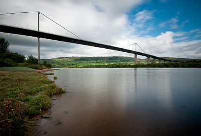
Erskine Bridge is a road crossing that spans the banks of the Clyde between Renfrewshire and West Dunbartonshire in Scotland. The steel structure reaches a total length of around 1,300 meters (about 4,300 feet) and stands roughly 45 meters (approximately 150 feet) tall, supported by a central mast system with slanted cables and a hollow beam design.

Construction started in 1967 and was formally opened by Princess Anne on July 2, 1971, replacing the ferry that previously connected both banks. The finished crossing was seen as a breakthrough for cable-stayed design in Britain at the time of its completion.

The crossing takes its name from a nearby village and now serves as an everyday link for commuters and travelers heading to Glasgow International Airport. Many drivers cross the bridge as a routine part of their journey north, unaware of the engineering effort that made it possible.

The crossing carries around 35,000 vehicles each day and remains open to traffic at all times, with no toll fees charged since 2006. Pedestrians and cyclists can use a separate path that runs alongside the traffic lanes.

When completed, the main span of 305 meters (around 1,000 feet) held the longest distance for a cable-stayed bridge with a hollow beam anywhere in the world. That record stood for several years before other similar crossings surpassed it in the 1970s.

Location: Renfrewshire

Location: West Dunbartonshire

Official opening: July 2, 1971

Height: 45 m

Length: 1,321.87 m

Longest Span: 305 m

GPS coordinates: 55.92030,-4.46222

Latest update: December 5, 2025 22:26

Around this place
Show the full map
Forth and Clyde Canal
United Kingdom

Forth and Clyde Canal

1.6 km
Titan Clydebank
United Kingdom

Titan Clydebank

4.4 km
Cochno Stone
United Kingdom

Cochno Stone

4.5 km
India of Inchinnan
United Kingdom

India of Inchinnan

4 km
Dunglass Castle
United Kingdom

Dunglass Castle

2.7 km
Ingliston Country Club & Hotel
United Kingdom

Ingliston Country Club & Hotel

4.2 km
Blantyre Monument
United Kingdom

Blantyre Monument

2.2 km
Beardmore Crane
United Kingdom

Beardmore Crane

2.4 km
Lamont Farm
United Kingdom

Lamont Farm

2.5 km
Clydebank, 49 Dumbarton Road, Municipal Buildings
United Kingdom

Clydebank, 49 Dumbarton Road, Municipal Buildings

4 km
Morison Memorial church
United Kingdom

Morison Memorial church

4 km
Clydebank Museum
United Kingdom

Clydebank Museum

4 km
Grey Mare's Tail, Kilpatrick Hills
United Kingdom

Grey Mare's Tail, Kilpatrick Hills

4.7 km
Erskine House
United Kingdom

Erskine House

1 km
Clydebank, Hall Street, Baths & Fire Station Tenement
United Kingdom

Clydebank, Hall Street, Baths & Fire Station Tenement

4 km
Clydebank Library
United Kingdom

Clydebank Library

4 km
Mountblow Football Pavilion, Lilac Avenue, Clydebank
United Kingdom

Mountblow Football Pavilion, Lilac Avenue, Clydebank

1.6 km
Empire Cinema
United Kingdom

Empire Cinema

4.1 km
Dalmuir Library
United Kingdom

Dalmuir Library

2.3 km
Forth And Clyde Canal, Bowling Harbour, Railway Swing Bridge And Approach Viaducts
United Kingdom

Forth And Clyde Canal, Bowling Harbour, Railway Swing Bridge And Approach Viaducts

1.6 km
Erskine House, Ferry Lodge
United Kingdom

Erskine House, Ferry Lodge

335 m
Forth And Clyde Canal, Bowling Basin, Drawbridge
United Kingdom

Forth And Clyde Canal, Bowling Basin, Drawbridge

1.6 km
Forth and Clyde Canal: Old Kilpatrick - Linnvale
United Kingdom

Forth and Clyde Canal: Old Kilpatrick - Linnvale

2.1 km
Forth And Clyde Canal, Bowling Harbour, Customs House
United Kingdom

Forth And Clyde Canal, Bowling Harbour, Customs House

1.6 km
Clydebank, 11 Hume Street
United Kingdom

Clydebank, 11 Hume Street

4.3 km
Bowling, Dumbarton Road, Public Park, War Memorial
United Kingdom

Bowling, Dumbarton Road, Public Park, War Memorial

1.7 km
Former Public Baths And Swimming Pool, Bruce Street
United Kingdom

Former Public Baths And Swimming Pool, Bruce Street

4.1 km
Clydebank, 2 Sylvania Way South, Clydebank Co-operative Society
United Kingdom

Clydebank, 2 Sylvania Way South, Clydebank Co-operative Society

4.2 km
Show the full map

Reviews

Visited this place? Tap the stars to rate it and share your experience / photos with the community! Try now! You can cancel it anytime.

« Erskine Bridge - Cable-stayed bridge in Renfrewshire and West Dunbartonshire, Scotland » is provided by Around Us (aroundus.com). Images and texts are derived from Wikimedia project under a Creative Commons license. You are allowed to copy, distribute, and modify copies of this page, under the conditions set by the license, as long as this note is clearly visible.

Discover hidden gems everywhere you go!

From secret cafés to breathtaking viewpoints, skip the crowded tourist spots and find places that match your style. Our app makes it easy with voice search, smart filtering, route optimization, and insider tips from travelers worldwide. Download now for the complete mobile experience.

Around Us App Screenshot

A unique approach to discovering new places

Le Figaro

All the places worth exploring

France Info

A tailor-made excursion in just a few clicks

20 Minutes