Enable Location

We need your location to show you interesting places around you

Discover nearby places

Find interesting locations and hidden gems around you

Precise directions

Get accurate directions and distances to places

Your location is never shared with other users. It's only used when you tap the location button.

Escowbeck

Log in to your account

Start exploring — it's free

Trusted by 63,472 travelers worldwide

Continue with Google
Continue with Apple
or

We will send you a code to connect

By continuing, you accept our Terms and Conditions and our Privacy Policy

Check your inbox

We've sent a pincode in your inbox. Please enter the code below.

Escowbeck
Discussion Reviews 1 Photos
1.9k Popularity

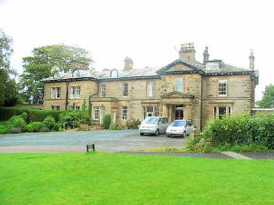
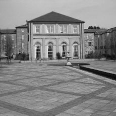
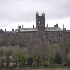
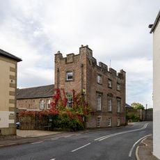
Escowbeck, English country house in Quernmore, Great Britain

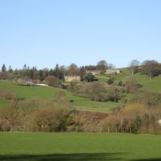
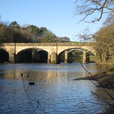
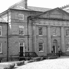
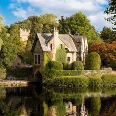
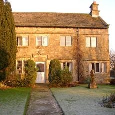
Escowbeck is a stone manor house located on Caton Lane with traditional architectural features and classical proportions. The building has been converted into residential apartments and overlooks the valley of the Crook of Lune from its elevated position.

The house was built in 1842 for John Greg, a mill owner and newspaper founder in the local area. This period marked the growth of industrial enterprise in Lancashire during the Victorian era.

The name comes from Old Norse roots meaning the stream by the ash tree hill. This ancient naming reflects how the landscape has been understood by people over many centuries.

The property sits alongside the A683 road and is visible from the main route through the valley. The location provides good views over the surrounding landscape and is accessible by vehicle from the main road.

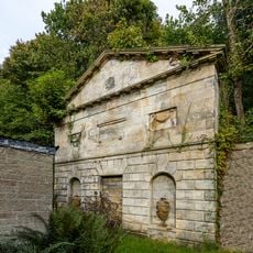
An observatory was built at the site where John Phillip Greg conducted astronomical observations of the night sky. His research helped identify a major meteor shower that still bears his family name.

The community of curious travelers

AroundUs brings together thousands of curated places, local tips, and hidden gems, enriched daily by 60,000 contributors worldwide.

Start exploring
Location
Inception
1842
GPS coordinates
54.07200,-2.72500
Latest update
December 14, 2025 11:00
Around this place
St Wilfrid's Church, Halton-on-Lune
United Kingdom

St Wilfrid's Church, Halton-on-Lune

2.8 km
St Paul's Church, Brookhouse
United Kingdom

St Paul's Church, Brookhouse

1.6 km
St Peter's Church, Quernmore
United Kingdom

St Peter's Church, Quernmore

4 km
St Michael's Chapel, Lancaster Moor Hospital
United Kingdom

St Michael's Chapel, Lancaster Moor Hospital

4.3 km
St Saviour's Church, Aughton
United Kingdom

St Saviour's Church, Aughton

4.1 km
Littledale Free Church
United Kingdom

Littledale Free Church

4.4 km
Halton narrow toll bridge
United Kingdom

Halton narrow toll bridge

2.4 km
Halton Park
United Kingdom

Halton Park

1.7 km
Bradshaw Mausoleum, Halton Churchyard
United Kingdom

Bradshaw Mausoleum, Halton Churchyard

2.8 km
Western railway bridge over the River Lune at Crook of Lune
United Kingdom

Western railway bridge over the River Lune at Crook of Lune

822 m
White Lion Hotel And Coach House Adjoining To North-East
United Kingdom

White Lion Hotel And Coach House Adjoining To North-East

2.7 km
Halton Road Bridge
United Kingdom

Halton Road Bridge

4.3 km
Eastern railway bridge over the River Lune at Crook of Lune
United Kingdom

Eastern railway bridge over the River Lune at Crook of Lune

658 m
Moor Hospital, New Block
United Kingdom

Moor Hospital, New Block

4.1 km
Milestone
United Kingdom

Milestone

1.2 km
Milestone
United Kingdom

Milestone

4.3 km
Caton Lune Bridge
United Kingdom

Caton Lune Bridge

611 m
Moor Hospital, Blocks 40,41,42,44 And 46
United Kingdom

Moor Hospital, Blocks 40,41,42,44 And 46

4.4 km
Milestone
United Kingdom

Milestone

1.2 km
The Boat House
United Kingdom

The Boat House

2.7 km
High cross in St Wilfrid's churchyard, Halton
United Kingdom

High cross in St Wilfrid's churchyard, Halton

2.8 km
Pair Of Gatepiers At Entrance To Churchyard To South Of The Church Of St Wilfrid
United Kingdom

Pair Of Gatepiers At Entrance To Churchyard To South Of The Church Of St Wilfrid

2.8 km
Tower House And Former Stables And Barn Adjoining
United Kingdom

Tower House And Former Stables And Barn Adjoining

2.7 km
Lancaster Canal Dolphinlee Bridge (Number 105)
United Kingdom

Lancaster Canal Dolphinlee Bridge (Number 105)

4.2 km
Milestone
United Kingdom

Milestone

2.7 km
Halton-with-Aughton War Memorial
United Kingdom

Halton-with-Aughton War Memorial

2.7 km
Manor House
United Kingdom

Manor House

2.4 km
Milestone, Lancaster Road, at appex of main curve on Crook o' Lune, E of the Hotel
United Kingdom

Milestone, Lancaster Road, at appex of main curve on Crook o' Lune, E of the Hotel

445 m
Show the full map
Reviews
Share your experience

No review yet

Discussions
Start a discussion...

No discussion yet

« Escowbeck - English country house in Quernmore, Great Britain » is provided by Around Us (aroundus.com). Images and texts are derived from Wikimedia project under a Creative Commons license. You are allowed to copy, distribute, and modify copies of this page, under the conditions set by the license, as long as this note is clearly visible.

Discover hidden gems everywhere you go!

From secret cafés to breathtaking viewpoints, skip the crowded tourist spots and find places that match your style. Our app makes it easy with voice search, smart filtering, route optimization, and insider tips from travelers worldwide. Download now for the complete mobile experience.

Around Us App Screenshot

A unique approach to discovering new places

Le Figaro

All the places worth exploring

France Info

A tailor-made excursion in just a few clicks

20 Minutes

Around Us
Travel Guide & Maps
Download

Send to your phone

QR Code
1

Open the camera app on your mobile.

2

Point at the QR code with your camera. A notification will appear.

3

Tap the notification to open the link.