Garrison Point Fort

Log in to your account

AroundUs is a community-driven map of interesting places, built by curious explorers like you. It grows with every review, story, and photo you share.
Connect to save your favorite spots, contribute locations, and create personalized routes.
Continue with Google
Continue with Apple
Continue with X
Continue with Facebook
Continue with email
By continuing, you accept our Terms and Conditions and our Privacy Policy
Create an account
Add to collection
Map
Suggest a change
Share

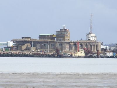
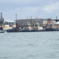
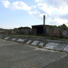
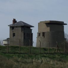
Garrison Point Fort, Military fort in Sheerness, England

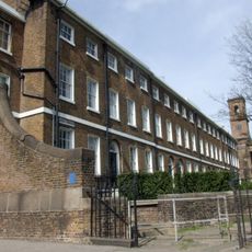
Garrison Point Fort is a semicircular fortification in Sheerness with two gun floors featuring iron shields for protection. The structure stands at the junction where the Medway river meets the Thames, built to defend this strategic waterway.

Construction of the fort took place between 1861 and 1872 as Britain prepared its coastline against potential French naval attacks. The Victorian period saw such fortifications built across southern England in response to international tensions.

The fort shows how Victorians approached coastal protection and reflects the era's concern about foreign threats to Britain. It remains embedded in Sheerness's port landscape as a tangible link to 19th-century military thinking and local maritime identity.

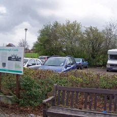
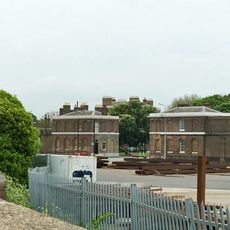
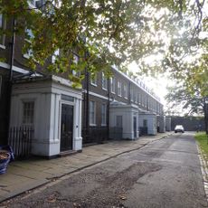
The fort is located within an active port and is not open to the public for safety and operational reasons. You can view it from outside the port perimeter or at a distance along the waterfront.

The fort is one of only two double-tiered casemated fortifications built in Britain during the 1860s. This rare construction method makes it an important example of Victorian military engineering that few people know about.

Location: Swale

Location: Sheerness

Inception: 1861

GPS coordinates: 51.44690,0.74441

Latest update: December 9, 2025 18:48

Photos
Around this place
Grain Tower
United Kingdom

Grain Tower

1 km
United Kingdom

Grain Fort

2.1 km
Queenborough Castle
United Kingdom

Queenborough Castle

3.4 km
Great Mill
United Kingdom

Great Mill

1.6 km
Shed No. 78
United Kingdom

Shed No. 78

277 m
Town Hall
United Kingdom

Town Hall

3.3 km
The Hogarth Inn
United Kingdom

The Hogarth Inn

2.4 km
The Criterion Blue Town
United Kingdom

The Criterion Blue Town

621 m
Church of St James
United Kingdom

Church of St James

2.3 km
Parish Church of the Holy Trinity
United Kingdom

Parish Church of the Holy Trinity

1.6 km
Parish Church of the Holy Trinity
United Kingdom

Parish Church of the Holy Trinity

3.3 km
Roman Catholic Church of St Henry and St Elizabeth
United Kingdom

Roman Catholic Church of St Henry and St Elizabeth

1.8 km
Sheerness War Memorial
United Kingdom

Sheerness War Memorial

1.2 km
Monument To Greet Family In Churchyard Of Holy Trinity Parish Church
United Kingdom

Monument To Greet Family In Churchyard Of Holy Trinity Parish Church

3.3 km
Red Lion Public House
United Kingdom

Red Lion Public House

653 m
Former Royal Dockyard Church And Attached Wall And Railings
United Kingdom

Former Royal Dockyard Church And Attached Wall And Railings

773 m
World War Ii Anti-Tank Obstacles On The Foreshore
United Kingdom

World War Ii Anti-Tank Obstacles On The Foreshore

2.9 km
King William Lion Monument To West Of Medway Port Authority Offices
United Kingdom

King William Lion Monument To West Of Medway Port Authority Offices

647 m
Remains Of Windmill In Grounds Of Seaview Hotel
United Kingdom

Remains Of Windmill In Grounds Of Seaview Hotel

1.8 km
Coastal artillery defences on the Isle of Grain, immediately east and south east of Grain village
United Kingdom

Coastal artillery defences on the Isle of Grain, immediately east and south east of Grain village

1.7 km
Queenborough Lines
United Kingdom

Queenborough Lines

2.1 km
North Gate House
United Kingdom

North Gate House

578 m
Numbers 1 To 15 And Attached Railings
United Kingdom

Numbers 1 To 15 And Attached Railings

700 m
Railings To South Side Of Green To East Of Naval Terrace
United Kingdom

Railings To South Side Of Green To East Of Naval Terrace

841 m
South Gate House
United Kingdom

South Gate House

605 m
Numbers 1 To 8 Attached Basement Railings, Walls, Coach House And Stables
United Kingdom

Numbers 1 To 8 Attached Basement Railings, Walls, Coach House And Stables

821 m
Clock Tower
United Kingdom

Clock Tower

1.5 km
Sheerness defences
United Kingdom

Sheerness defences

677 m
Show the full map
Reviews

Visited this place? Tap the stars to rate it and share your experience / photos with the community! Try now! You can cancel it anytime.

« Garrison Point Fort - Military fort in Sheerness, England » is provided by Around Us (aroundus.com). Images and texts are derived from Wikimedia project under a Creative Commons license. You are allowed to copy, distribute, and modify copies of this page, under the conditions set by the license, as long as this note is clearly visible.

Discover hidden gems everywhere you go!

From secret cafés to breathtaking viewpoints, skip the crowded tourist spots and find places that match your style. Our app makes it easy with voice search, smart filtering, route optimization, and insider tips from travelers worldwide. Download now for the complete mobile experience.

Around Us App Screenshot

A unique approach to discovering new places

Le Figaro

All the places worth exploring

France Info

A tailor-made excursion in just a few clicks

20 Minutes