·

Enable Location

We need your location to show you interesting places around you

Discover nearby places

Find interesting locations and hidden gems around you

Precise directions

Get accurate directions and distances to places

Your location is never shared with other users. It's only used when you tap the location button.

Hexham Old Bridge

Log in to your account

Start exploring — it's free

Trusted by 62,653 travelers worldwide

Continue with Google
Continue with Apple
or

We will send you a code to connect

By continuing, you accept our Terms and Conditions and our Privacy Policy

Check your inbox

We've sent a pincode in your inbox. Please enter the code below.

Hexham Old Bridge

Hexham Old Bridge, Stone bridge in Hexham, England

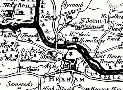
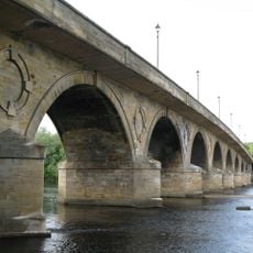
Hexham Old Bridge is a stone structure crossing the River Tyne with seven arches built from carefully cut stone blocks. The solid construction has supported foot traffic and vehicles for generations, forming an essential connection between the town and surrounding areas.

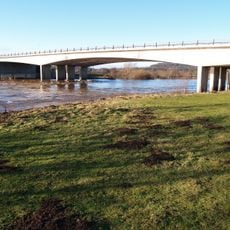
Construction finished in 1770, but the great Tyne flood of 1771 severely damaged the structure just a year later. The bridge was rebuilt and has endured since then, with modifications made over time to accommodate changing transportation needs.

The bridge reflects local building traditions through its use of regional stone and skilled craftsmanship. Pedestrians and vehicles still cross it daily in the same way people have for centuries.

The bridge is freely accessible from both sides and provides a practical crossing for both pedestrians and vehicles at any time. The stone surface can be slippery when wet, so care should be taken during rain or damp conditions.

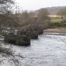
Workers discovered quicksand beneath the gravel during a 1774 reconstruction attempt, forcing engineers to abandon that approach. This hidden geological challenge revealed just how unpredictable the riverbed could be.

The community of curious travelers

AroundUs brings together thousands of curated places, local tips, and hidden gems, enriched daily by 60,000 contributors worldwide.

Start exploring
Inception
1770
GPS coordinates
54.98200,-2.11200
Latest update
December 14, 2025 14:40
Around this place
Hexham Abbey
United Kingdom

Hexham Abbey

1.3 km
Hexham Bridge
United Kingdom

Hexham Bridge

1.3 km
Border Counties Bridge
United Kingdom

Border Counties Bridge

556 m
Constantius Bridge
United Kingdom

Constantius Bridge

832 m
Church of St John of Beverley
United Kingdom

Church of St John of Beverley

585 m
War Memorial to North-East of Church of St John
United Kingdom

War Memorial to North-East of Church of St John

582 m
Archway To Church Flags  Archway To Cowgarth
United Kingdom

Archway To Church Flags Archway To Cowgarth

1.3 km
Heart Of All England Tavern
United Kingdom

Heart Of All England Tavern

1.3 km
Bridge Over Halgut Burn In Grounds Of Hexham House
United Kingdom

Bridge Over Halgut Burn In Grounds Of Hexham House

1.2 km
Drinking Fountain To South Of Central Range Of Hexham County Primary Infant And Junior School
United Kingdom

Drinking Fountain To South Of Central Range Of Hexham County Primary Infant And Junior School

1.1 km
Hexham Primary Infants And Junior School
United Kingdom

Hexham Primary Infants And Junior School

1.1 km
Holy Island House
United Kingdom

Holy Island House

1 km
Hexham House
United Kingdom

Hexham House

1.2 km
St Wilfrid's Gateway The Priory Gatehouse
United Kingdom

St Wilfrid's Gateway The Priory Gatehouse

1.2 km
3, Market Street
United Kingdom

3, Market Street

1.3 km
Footbridge Over The Birkey Burn 220 Metres South Of Acomb House
United Kingdom

Footbridge Over The Birkey Burn 220 Metres South Of Acomb House

1 km
Pant With Adjacent Hydrant
United Kingdom

Pant With Adjacent Hydrant

1.3 km
20 And 22, Market Street
United Kingdom

20 And 22, Market Street

1.2 km
24, Market Street
United Kingdom

24, Market Street

1.2 km
6 And 8, Market Street
United Kingdom

6 And 8, Market Street

1.3 km
Milestone South Of Old Road 12 Metres West Of Entrance To The Hermitage
United Kingdom

Milestone South Of Old Road 12 Metres West Of Entrance To The Hermitage

727 m
Hydrant 5 Metres South-West Of Cartshed South Of Fold Cottage
United Kingdom

Hydrant 5 Metres South-West Of Cartshed South Of Fold Cottage

1.3 km
2, Gilesgate
United Kingdom

2, Gilesgate

1.1 km
9, Market Street
United Kingdom

9, Market Street

1.2 km
Wall To Bowling Green, From Hexham House To Priory Gateway
United Kingdom

Wall To Bowling Green, From Hexham House To Priory Gateway

1.2 km
27 And 28, Market Place
United Kingdom

27 And 28, Market Place

1.3 km
The Spital
United Kingdom

The Spital

331 m
The Hermitage
United Kingdom

The Hermitage

716 m
Show the full map
« Hexham Old Bridge - Stone bridge in Hexham, England » is provided by Around Us (aroundus.com). Images and texts are derived from Wikimedia project under a Creative Commons license. You are allowed to copy, distribute, and modify copies of this page, under the conditions set by the license, as long as this note is clearly visible.

Discover hidden gems everywhere you go!

From secret cafés to breathtaking viewpoints, skip the crowded tourist spots and find places that match your style. Our app makes it easy with voice search, smart filtering, route optimization, and insider tips from travelers worldwide. Download now for the complete mobile experience.

Around Us App Screenshot

A unique approach to discovering new places

Le Figaro

All the places worth exploring

France Info

A tailor-made excursion in just a few clicks

20 Minutes

Around Us
Travel Guide & Maps
Download

Send to your phone

QR Code
1

Open the camera app on your mobile.

2

Point at the QR code with your camera. A notification will appear.

3

Tap the notification to open the link.