Enable Location

We need your location to show you interesting places around you

Discover nearby places

Find interesting locations and hidden gems around you

Precise directions

Get accurate directions and distances to places

Your location is never shared with other users. It's only used when you tap the location button.

Maryon Park

Log in to your account

Start exploring — it's free

Trusted by 61,369 travelers worldwide

Continue with Google
Continue with Apple
or

We will send you a code to connect

By continuing, you accept our Terms and Conditions and our Privacy Policy

Check your inbox

We've sent a pincode in your inbox. Please enter the code below.

Maryon Park

Maryon Park, Urban park in Charlton, United Kingdom.

Description

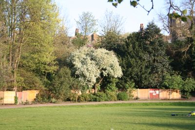
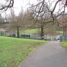
Maryon Park is an urban park south of the Thames Barrier with steep hillsides and winding paths running through grassland. Hawkweed, gorse, and broom grow across the slopes, creating pockets of shrubby growth throughout the terrain.

History

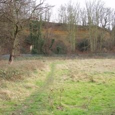
This location was once called Hanging Wood and came to the London County Council from the Maryon-Wilson family in 1891 as a former quarry site. The transfer marked the beginning of its transformation into public green space.

Culture

The park gained international attention when director Michelangelo Antonioni chose it as a main filming location for his 1966 film Blowup. The film scenes continue to shape how visitors from around the world perceive this place.

Practical

The park has several recreational facilities including tennis courts, a basketball court, and a children's playground for visitors of all ages. The Capital Ring and Green Chain walking trails run through the grounds and link it with other green spaces in the area.

Did you know?

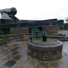
Cox's Mount was once a Roman fortification and later served ships on the Thames in the 1850s as a reference point for calibrating their compasses. This double historical importance of the hill often goes unnoticed by visitors today.

Location
Operator
Greenwich London Borough Council
GPS coordinates
51.48900,0.04300
Latest update
December 8, 2025 20:00

AroundUs brings together thousands of curated places, local tips, and hidden gems, enriched daily by 60,000 contributors worldwide. Discover all places nearby (Charlton).

Around this place
St Luke's Church
United Kingdom

St Luke's Church

946 m
Maryon Wilson Park
United Kingdom

Maryon Wilson Park

479 m
Gilbert's Pit
United Kingdom

Gilbert's Pit

107 m
Barrier Gardens Pier
United Kingdom

Barrier Gardens Pier

740 m
Rotunda
United Kingdom

Rotunda

875 m
The Valley
United Kingdom

The Valley

538 m
Church of St Thomas
United Kingdom

Church of St Thomas

254 m
Church of St Michael and All Angels
United Kingdom

Church of St Michael and All Angels

756 m
Bugle Horn Inn
United Kingdom

Bugle Horn Inn

934 m
Former Police Station To Royal Dockyard
United Kingdom

Former Police Station To Royal Dockyard

517 m
Cambridge Barracks Entrance
United Kingdom

Cambridge Barracks Entrance

851 m
Royal Dockyard Clock House (Facing Entrance)
United Kingdom

Royal Dockyard Clock House (Facing Entrance)

890 m
Royal Dockyard Gun Emplacements On Riverside To North East Of Entrance And Gunposts Facing
United Kingdom

Royal Dockyard Gun Emplacements On Riverside To North East Of Entrance And Gunposts Facing

971 m
Chimney To Steam Factory, Former Royal Dockyard
United Kingdom

Chimney To Steam Factory, Former Royal Dockyard

567 m
Forecourt Railings And Gates To Red Barracks, And Gate Lodge
United Kingdom

Forecourt Railings And Gates To Red Barracks, And Gate Lodge

793 m
Charlton War Memorial
United Kingdom

Charlton War Memorial

980 m
Numbers 106 To 110 Including Attached Walls And Railings
United Kingdom

Numbers 106 To 110 Including Attached Walls And Railings

589 m
Former Siemens Cable Factory, 37 Bowater Road
United Kingdom

Former Siemens Cable Factory, 37 Bowater Road

563 m
Charlton Assembly Rooms
United Kingdom

Charlton Assembly Rooms

846 m
Royal Dockyard Entrance Gateway Piers And Abutting Walls
United Kingdom

Royal Dockyard Entrance Gateway Piers And Abutting Walls

841 m
153-159, Woodhill Se18
United Kingdom

153-159, Woodhill Se18

548 m
Woodhill School
United Kingdom

Woodhill School

438 m
118 And 120, Woodhill Se18
United Kingdom

118 And 120, Woodhill Se18

611 m
Royal Dockyard Police Building At East Side Of Entrance Gateway
United Kingdom

Royal Dockyard Police Building At East Side Of Entrance Gateway

854 m
North Boundary Walls To Grounds Of Royal Military Repository, From Corner Of Repository Road Westwards Almost To Opposite Maryon Road
United Kingdom

North Boundary Walls To Grounds Of Royal Military Repository, From Corner Of Repository Road Westwards Almost To Opposite Maryon Road

785 m
Beresford Terrace
United Kingdom

Beresford Terrace

679 m
Former Smithery, Erecting Shop And Brass Foundry, Royal Dockyard
United Kingdom

Former Smithery, Erecting Shop And Brass Foundry, Royal Dockyard

580 m
Green Hill Garrison School
United Kingdom

Green Hill Garrison School

908 m
Show the full map
« Maryon Park - Urban park in Charlton, United Kingdom » is provided by Around Us (aroundus.com). Images and texts are derived from Wikimedia project under a Creative Commons license. You are allowed to copy, distribute, and modify copies of this page, under the conditions set by the license, as long as this note is clearly visible.

Discover hidden gems everywhere you go!

From secret cafés to breathtaking viewpoints, skip the crowded tourist spots and find places that match your style. Our app makes it easy with voice search, smart filtering, route optimization, and insider tips from travelers worldwide. Download now for the complete mobile experience.

Around Us App Screenshot

A unique approach to discovering new places

Le Figaro

All the places worth exploring

France Info

A tailor-made excursion in just a few clicks

20 Minutes

Around Us
Travel Guide & Maps
Download

Send to your phone

QR Code
1

Open the camera app on your mobile.

2

Point at the QR code with your camera. A notification will appear.

3

Tap the notification to open the link.