Loring Hall

Log in to your account

AroundUs is a community-driven map of interesting places, built by curious explorers like you. It grows with every review, story, and photo you share.
Connect to save your favorite spots, contribute locations, and create personalized routes.
By continuing, you accept our Terms and Conditions and our Privacy Policy
Add to collection
Map
Suggest a change
Share

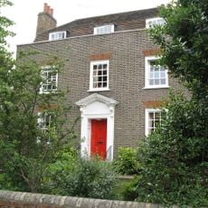
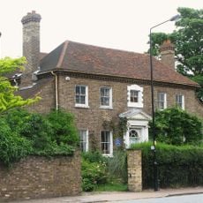
Loring Hall, Grade II listed country house in North Cray, United Kingdom.

Loring Hall stands as a substantial brick building featuring traditional architectural elements, symmetrical windows, and refined exterior decorations from the 18th century.

The residence gained recognition when British Foreign Secretary Viscount Castlereagh lived there from 1811 until his death by suicide in 1822.

Goldsmiths College renamed the building to honor Captain William Loring, their first warden who sacrificed his life at Gallipoli during World War I.

The building now functions as a specialized care facility for individuals with learning disabilities, continuing its legacy of service to the community.

English Heritage placed a blue plaque on the building to commemorate Viscount Castlereagh's residency and tragic end at this location.

Location: London Borough of Bexley

GPS coordinates: 51.43080,0.13944

Latest update: March 3, 2025 00:24

Photos
Around this place
Show the full map
Foots Cray Meadows
United Kingdom

Foots Cray Meadows

1 km
The King's Head Inn
United Kingdom

The King's Head Inn

1.4 km
Parish Church of St John the Evangelist
United Kingdom

Parish Church of St John the Evangelist

1.3 km
Parish Church of St Mary the Virgin
United Kingdom

Parish Church of St Mary the Virgin

1.4 km
Parish Church of All Saints
United Kingdom

Parish Church of All Saints

1.6 km
St. Andrew's
United Kingdom

St. Andrew's

879 m
Parish Church of St James
United Kingdom

Parish Church of St James

743 m
Coal Duty Boundary Marker (In The Fence To The Back Of The Garden Of Number 57 Baldwyn's Park) And Adjacent Iron Bollard
United Kingdom

Coal Duty Boundary Marker (In The Fence To The Back Of The Garden Of Number 57 Baldwyn's Park) And Adjacent Iron Bollard

1.8 km
Pillar Box Beside Number 48 At Junction With Parkhurst Road
United Kingdom

Pillar Box Beside Number 48 At Junction With Parkhurst Road

1.4 km
The Seven Stars Public House
United Kingdom

The Seven Stars Public House

2 km
Bexley War Memorial
United Kingdom

Bexley War Memorial

1.3 km
Faesten Dic, a medieval frontier work in Joydens Wood
United Kingdom

Faesten Dic, a medieval frontier work in Joydens Wood

1.6 km
North Cray War Memorial
United Kingdom

North Cray War Memorial

726 m
Five Arch Bridge
United Kingdom

Five Arch Bridge

771 m
Coal Duty Boundary Marker (On The South Side Of Number 1)
United Kingdom

Coal Duty Boundary Marker (On The South Side Of Number 1)

1.9 km
Stable Block To Former Foots Cray Place
United Kingdom

Stable Block To Former Foots Cray Place

1.5 km
1st Bexleyheath Scout Group Memorial
United Kingdom

1st Bexleyheath Scout Group Memorial

1.3 km
Lodge To Hurstmere School
United Kingdom

Lodge To Hurstmere School

1.9 km
Walls Surrounding And To West And South West Of Parish Church Of St James And Gatepiers And Gates To West Of Church
United Kingdom

Walls Surrounding And To West And South West Of Parish Church Of St James And Gatepiers And Gates To West Of Church

752 m
Bowling Pavillion, Foots Cray Place
United Kingdom

Bowling Pavillion, Foots Cray Place

1.6 km
Cray House
United Kingdom

Cray House

1.4 km
16, North Cray Road
United Kingdom

16, North Cray Road

1.3 km
Two Chest Tombs To East Side Of Parish Church Of St James
United Kingdom

Two Chest Tombs To East Side Of Parish Church Of St James

731 m
High Street House
United Kingdom

High Street House

1.4 km
Tomb Of Frances Madocks To South Side Of Parish Church Of St James
United Kingdom

Tomb Of Frances Madocks To South Side Of Parish Church Of St James

752 m
Milepost, Hurst Road, nr jct with Bexley High Street, by Church Hall
United Kingdom

Milepost, Hurst Road, nr jct with Bexley High Street, by Church Hall

1.3 km
Lychgate to South West of Parish Church of St Mary the Virgin
United Kingdom

Lychgate to South West of Parish Church of St Mary the Virgin

1.4 km
Milestone, Old Bexley Lane, 40m E of Kent Boundary post
United Kingdom

Milestone, Old Bexley Lane, 40m E of Kent Boundary post

2 km
Show the full map
Reviews

Visited this place? Tap the stars to rate it and share your experience / photos with the community! Try now! You can cancel it anytime.

« Loring Hall - Grade II listed country house in North Cray, United Kingdom » is provided by Around Us (aroundus.com). Images and texts are derived from Wikimedia project under a Creative Commons license. You are allowed to copy, distribute, and modify copies of this page, under the conditions set by the license, as long as this note is clearly visible.

Discover hidden gems everywhere you go!

From secret cafés to breathtaking viewpoints, skip the crowded tourist spots and find places that match your style. Our app makes it easy with voice search, smart filtering, route optimization, and insider tips from travelers worldwide. Download now for the complete mobile experience.

Around Us App Screenshot

A unique approach to discovering new places

Le Figaro

All the places worth exploring

France Info

A tailor-made excursion in just a few clicks

20 Minutes