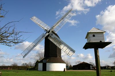
Outwood Windmill, Post mill in Outwood, Surrey, United Kingdom
Outwood Windmill is a wooden post mill featuring four rotating sails and multiple internal levels where grain was ground into flour. The building preserves its original milling machinery, gears, and mechanisms that powered the grinding process.
Thomas Budgen built this mill in 1665 during the era when windmills were essential to English farming. The structure dates from a period when wind-powered milling represented the most advanced grain processing technology available.
The mill represents traditional English agricultural practices, demonstrating the mechanics of wind-powered grain processing through its preserved internal machinery.
Visit on clear, breezy days when you can explore the interior levels more comfortably and see how the sails would move in the wind. Wear sturdy shoes as the building has narrow staircases and uneven floors throughout.
The mill operates using four spring-controlled sails that could adjust automatically to wind pressure without stopping the machinery. This engineering solution allowed millers to regulate sail tension and power output while the mill continued working.
Location: Outwood
GPS coordinates: 51.19380,-0.10131
Latest update: December 12, 2025 08:01
London England Temple
4.9 km
British Wildlife Centre
4.3 km
Church of St John the Baptist, Outwood
939 m
Archway Theatre
5 km
Church of St Mary the Virgin
1.5 km
Church of St John the Evanglist
3.3 km
Church of St Bartholomew
4.5 km
Church of St Mary the Virgin
5.3 km
Chapel Of St Mark
3.6 km
St Stephen
4.6 km
The Queens Head Public House
5.4 km
Milestone, Eastbourne Road, quarter mile S of Railway Bridge
4.2 km
Milestone, Blindley Heath Common
3.8 km
Hamme House
4.3 km
Kings Mill House
4.5 km
The White Hart Inn Including Former Stable To Rear
5.2 km
Horley War Memorial
5.3 km
The Manse
5.2 km
Milestone, The Grange, Eastbourne Road, Blindley Heath
3.3 km
Blindley Heath War Memorial
3.4 km
Staplehurst Farm House
4.3 km
Horne WWI Memorial, Surrey
1.5 km
Milepost, Pentridge Common, Horley Road, 200m N of jct with A2044 (was B2035)
5.1 km
40-44, High Street
5.4 km
Godstone Place
3.8 km
Milepost, Bonehurst Road, Salfords, just N of "X Ray House"
4.4 km
Milestone, Eastbourne Road, jct with Hart Lane
5.4 km
Brick Kiln
5 kmVisited this place? Tap the stars to rate it and share your experience / photos with the community! Try now! You can cancel it anytime.
Discover hidden gems everywhere you go!
From secret cafés to breathtaking viewpoints, skip the crowded tourist spots and find places that match your style. Our app makes it easy with voice search, smart filtering, route optimization, and insider tips from travelers worldwide. Download now for the complete mobile experience.
A unique approach to discovering new places❞
— Le Figaro
All the places worth exploring❞
— France Info
A tailor-made excursion in just a few clicks❞
— 20 Minutes