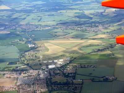
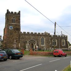
RAF Henlow, Military air base and museum in Bedfordshire, England
RAF Henlow is a Royal Air Force station in Bedfordshire that includes an aerodrome, military museum, and technical training facilities. The site currently operates the RAF Centre of Aerospace Medicine and hosts specialized departments for military operations.
The station was established in 1918 as an aircraft repair depot during World War I and later became an important training and testing center. It became Britain's first parachute testing center in 1920 and played a key role during World War II in refurbishing military aircraft.
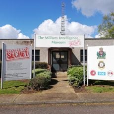
The Signals Museum here displayed developments in electronic communications from World War I until its closure in June 2024. It documented how radio and messaging technology evolved during the era of flight.
Access may be limited since this is an active military facility, so visitors should check requirements beforehand. Comfortable clothing and shoes are helpful when exploring the extensive grounds.
During World War II, this facility specialized in reassembling Hawker Hurricane aircraft that arrived by ship from Canada. These aircraft were then deployed by carriers to Malta for combat operations.
Location: Henlow
Location: Clifton
Elevation above the sea: 47 m
Address: Building 104, RAF Henlow, Henlow SG16 6DN
Website: https://raf.mod.uk/our-organisation/stations/raf-henlow
GPS coordinates: 52.01560,-0.30333
Latest update: December 7, 2025 20:24
Fairfield Hospital, Bedfordshire
4.1 km
Chicksands Priory
5.1 km
Henlow Grange
2.6 km
Parish Church of All Saints, Campton
3.8 km
Church of St Mary the Virgin, Henlow
2.5 km
Arlesey Old Moat and Glebe Meadows
2.5 km
Church of St Peter, Arlesey
2.8 km
Henlow Common and Langford Meadows
4.4 km
Church of St Andrew, Langford, Bedfordshire
5.2 km
Military Intelligence Museum
5.4 km
Church of All Saints
4.9 km
Church of All Saints
1.8 km
Church of St Mary the Virgin
3.1 km
Church of Saint Guthlac
5.2 km
Church of All Saints
2.7 km
Parish Church of St Michael and All Angels
3.3 km
Church of St Peter (C of E) at Corner with Holwell Road
3.3 km
Parish Church of Saint Giles
5.3 km
42, Church Street
4.9 km
14, 14A, 16 And 16A, Church Street
4.7 km
Church At Fairfield Hospital
4.1 km
The Five Bells Public House
4.7 km
The White Hart Public House
3.3 km
Well Head And War Memorial At Junction With Grange Street
2.4 km
Cadwell Farmhouse
4.9 km
Church Farmhouse
3.2 km
Manor House
3.2 km
Milestone, Arlersley Road, 160m S of jct with Regent Street
5 kmVisited this place? Tap the stars to rate it and share your experience / photos with the community! Try now! You can cancel it anytime.
Discover hidden gems everywhere you go!
From secret cafés to breathtaking viewpoints, skip the crowded tourist spots and find places that match your style. Our app makes it easy with voice search, smart filtering, route optimization, and insider tips from travelers worldwide. Download now for the complete mobile experience.
A unique approach to discovering new places❞
— Le Figaro
All the places worth exploring❞
— France Info
A tailor-made excursion in just a few clicks❞
— 20 Minutes