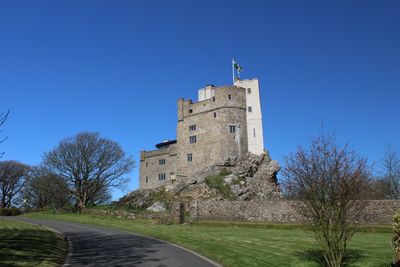
Roch Castle, 12th-century castle in Nolton and Roch, Wales, GB.
Roch Castle is a fortress from the 12th century built on a volcanic rock outcrop in Pembrokeshire, Wales. The structure rises from this rocky foundation with thick stone walls and defensive towers that command views across the surrounding landscape.
A Norman knight called Adam de Rupe built this fortress in 1195 as a strategic defense along the border between English and Welsh territories. During the English Civil War, it served as a military garrison until Parliament's forces captured and destroyed it in 1644.
The fortress served as a boundary marker between English and Welsh lands, making it an important symbol of territorial division during the medieval period. Today, visitors can see how its position shaped the cultural landscape of Pembrokeshire.
The site is accessible by a walking path, though reaching it requires some effort due to the slope and uneven rock surface. Visitors should wear sturdy footwear and be prepared for exposed conditions on the rocky summit, where wind can be stronger.
The fortress was the birthplace of Lucy Walter, whose son became the Duke of Monmouth and played a major role in later English history. This connection to the royal family through an unexpected branch adds a personal dimension to its military story.
The community of curious travelers
AroundUs brings together thousands of curated places, local tips, and hidden gems, enriched daily by 60,000 contributors worldwide.