Enable Location

We need your location to show you interesting places around you

Discover nearby places

Find interesting locations and hidden gems around you

Precise directions

Get accurate directions and distances to places

Your location is never shared with other users. It's only used when you tap the location button.

Sankey Viaduct

Log in to your account

Start exploring — it's free

Trusted by 62,900 travelers worldwide

Continue with Google
Continue with Apple
or

We will send you a code to connect

By continuing, you accept our Terms and Conditions and our Privacy Policy

Check your inbox

We've sent a pincode in your inbox. Please enter the code below.

Sankey Viaduct
Discussion Reviews 2 Photos
6.8k Popularity

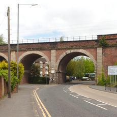
Sankey Viaduct, Railway viaduct in St Helens, England

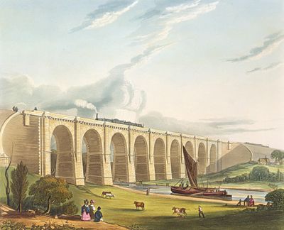
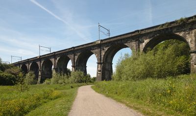
Sankey Viaduct is a railway viaduct in St Helens built from yellow sandstone and red brick with nine round-headed arches. It crosses the landscape as a solid structure that belongs to the earliest days of rail transport.

George Stephenson designed and supervised construction between 1828 and 1830 for the Liverpool-Manchester railway connection. Its completion marked a turning point in how England moved goods and people across distances.

The structure embodies the early railway age when engineers had to solve the puzzle of connecting different transport routes above and below. It shows how commerce and industrial growth shaped the region's infrastructure.

The viaduct is best viewed from nearby Earlestown station, which is reachable by Northern Rail services. Walking along the railway path offers different angles to see the entire structure.

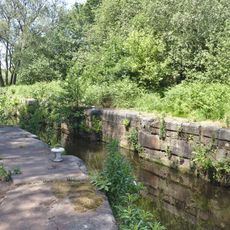
The viaduct crosses the Sankey Canal, one of England's first industrial waterways, with arch designs that allow tall sailing vessels to pass underneath. This solution shows the skill of early engineers in solving practical puzzles.

The community of curious travelers

AroundUs brings together thousands of curated places, local tips, and hidden gems, enriched daily by 60,000 contributors worldwide.

Start exploring
Location
Inception
September 15, 1830
Architects
George Stephenson
Width
7.6 m
GPS coordinates
53.44745,-2.65076
Latest update
December 9, 2025 18:41
Around this place
Church of St James the Great, Haydock
United Kingdom

Church of St James the Great, Haydock

2.3 km
St John the Baptist's Church, Earlestown
United Kingdom

St John the Baptist's Church, Earlestown

794 m
Earlestown Town Hall
United Kingdom

Earlestown Town Hall

791 m
Church of St Mary and St John, Newton-le-Willows
United Kingdom

Church of St Mary and St John, Newton-le-Willows

1.6 km
St Peter's Church, Newton-le Willows
United Kingdom

St Peter's Church, Newton-le Willows

2.6 km
Emmanuel Wargrave Church
United Kingdom

Emmanuel Wargrave Church

1.6 km
Newton-le-Willows United Reformed Chapel
United Kingdom

Newton-le-Willows United Reformed Chapel

2 km
Church of St Michael and All Angels, Burtonwood
United Kingdom

Church of St Michael and All Angels, Burtonwood

1.9 km
Mill Lane viaduct, Newton-le-Willows
United Kingdom

Mill Lane viaduct, Newton-le-Willows

2.5 km
Wood Pit and Lyme Pit disasters memorial
United Kingdom

Wood Pit and Lyme Pit disasters memorial

1.9 km
Bradlegh Old Hall
United Kingdom

Bradlegh Old Hall

899 m
158 and 160 High Street, Newton-le-Willows
United Kingdom

158 and 160 High Street, Newton-le-Willows

2.2 km
Bradley Swing Bridge, Sankey Canal
United Kingdom

Bradley Swing Bridge, Sankey Canal

789 m
Evans memorial, Newton-le-Willows United Reformed Chapel
United Kingdom

Evans memorial, Newton-le-Willows United Reformed Chapel

1.9 km
Haydock Colliery memorial at St James Church Haydock
United Kingdom

Haydock Colliery memorial at St James Church Haydock

2.3 km
Newton-le-Willows Library
United Kingdom

Newton-le-Willows Library

1.3 km
Earlestown War Memorial
United Kingdom

Earlestown War Memorial

797 m
Waiting room at Earlestown railway station
United Kingdom

Waiting room at Earlestown railway station

968 m
Parish stocks, Newton-le-Willows
United Kingdom

Parish stocks, Newton-le-Willows

2.6 km
All Saints, Newton-le-Willows
United Kingdom

All Saints, Newton-le-Willows

1.3 km
St Patrick's Church, Earlestown
United Kingdom

St Patrick's Church, Earlestown

709 m
St David's Church, Newton-le-Willows
United Kingdom

St David's Church, Newton-le-Willows

1.4 km
159 - 163 Crow Lane East, Newton-le-Willows
United Kingdom

159 - 163 Crow Lane East, Newton-le-Willows

1.6 km
Newton-le-Willows railway station building
United Kingdom

Newton-le-Willows railway station building

2.5 km
Earlestown Market Cross
United Kingdom

Earlestown Market Cross

851 m
Fairbrothers Farmhouse
United Kingdom

Fairbrothers Farmhouse

2 km
Bradley Lock, Sankey Canal
United Kingdom

Bradley Lock, Sankey Canal

544 m
Entrance archway To Randall's Nursery
United Kingdom

Entrance archway To Randall's Nursery

2.3 km
Show the full map
« Sankey Viaduct - Railway viaduct in St Helens, England » is provided by Around Us (aroundus.com). Images and texts are derived from Wikimedia project under a Creative Commons license. You are allowed to copy, distribute, and modify copies of this page, under the conditions set by the license, as long as this note is clearly visible.

Discover hidden gems everywhere you go!

From secret cafés to breathtaking viewpoints, skip the crowded tourist spots and find places that match your style. Our app makes it easy with voice search, smart filtering, route optimization, and insider tips from travelers worldwide. Download now for the complete mobile experience.

Around Us App Screenshot

A unique approach to discovering new places

Le Figaro

All the places worth exploring

France Info

A tailor-made excursion in just a few clicks

20 Minutes

Around Us
Travel Guide & Maps
Download

Send to your phone

QR Code
1

Open the camera app on your mobile.

2

Point at the QR code with your camera. A notification will appear.

3

Tap the notification to open the link.