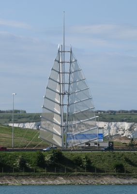
Sails of the South, Steel structure on M275 motorway in Portsmouth, United Kingdom.
Description
Sails of the South is a steel structure on the M275 motorway in Portsmouth that consists of three large sail-like forms mounted on tall metal posts. The installation spans both sides of the highway at Tipner Bridge and features violet lighting at night to serve as a landmark for approaching traffic.
History
The artwork was built in 2001 as part of the Gateway Project to modernize Portsmouth's entrance corridor. This installation marked a shift in how the city approached its visual identity when welcoming visitors by road.
Culture
The structure represents Portsmouth's connection to seafaring and maritime heritage, which has shaped the city's identity for centuries. Visitors immediately recognize through this artwork that they are approaching a place deeply rooted in naval tradition.
Practical
The structure is positioned between both directions of the motorway traffic and is easily visible from passing vehicles. The best time to photograph it is in the evening when the violet lighting is most effective.
Did you know?
In the 2000s, many of the lights were damaged by vandalism and remained unrepaired for years. This incident paradoxically made the installation even more noticeable as drivers recognized the incomplete lighting pattern.
AroundUs brings together thousands of curated places, local tips, and hidden gems, enriched daily by 60,000 contributors worldwide. Discover all places nearby (United Kingdom).
Portchester Castle
2.1 km
HMS Excellent
1.7 km
Wymering Manor
1.5 km
Portus Adurni
2.1 km
Hilsea Lines
1.5 km
Portchester Castle Visitor Centre
2.1 km
Church of St Peter and St Paul
1.5 km
Church of St Mary
2 km
Church of St John the Baptist
2 km
Cosham Park House
1.8 km
Fountain Public House And Attached Boundary Wall And Gate Piers
1.7 km
Cosham Library
2 km
511, London Road
1.2 km
Paulsgrove Library
1.8 km
Odeon Port Solent
1.4 km
Former Barn To North Of Green Farmhouse
1.5 km
Milestone: Hilsea Market Approximately 200 Metres South Of Military Road
1 km
Green Farmhouse
1.5 km
73 And 75, Kingston Crescent
2.2 km
Portchester House
2.2 km
65-71, Kingston Crescent
2.2 km
Lamp In St Mary's Churchyard
2 km
Churchyard Wall At St Mary's Churchyard
2 km
Milestone Adjacent To The Red Lion Public House (Public House Not Included)
2.1 km
Town Boundary Stone At Junction Of London Road And Torrington Road
1.3 km
61 And 63, Kingston Crescent
2.2 km
Scenic viewpoint
970 m
Lychgate At Entrance To St Mary's Churchyard
2 kmDiscover hidden gems everywhere you go!
From secret cafés to breathtaking viewpoints, skip the crowded tourist spots and find places that match your style. Our app makes it easy with voice search, smart filtering, route optimization, and insider tips from travelers worldwide. Download now for the complete mobile experience.
A unique approach to discovering new places❞
— Le Figaro
All the places worth exploring❞
— France Info
A tailor-made excursion in just a few clicks❞
— 20 Minutes