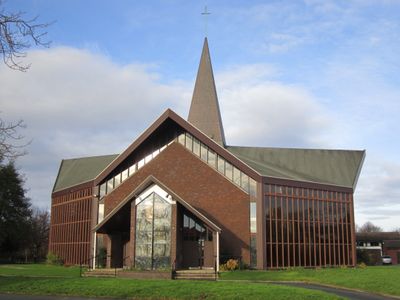
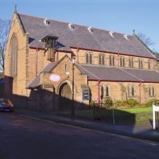
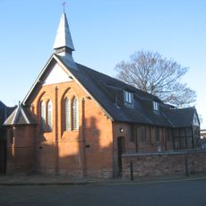
St Columba's Church, Chester, Catholic church in Newton, Chester, England
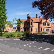
St Columba's Church is a Catholic place of worship in Newton, Chester, featuring architectural design typical of the 1960s. The building stands at the intersection of Plas Newton Lane and Newhall Road, with a parish hall added in 1978 that serves community gatherings and events.
The building was established in 1964 when a foundation stone was laid to mark the start of construction. The first religious service took place not long after, beginning its role in serving the local community.
The church serves the Catholic community of Chester and shares a joint parish with another nearby congregation. You can see how it functions as a gathering place for worship and community events throughout the year.
The church is located at a street intersection in a residential area, making it easy to find and access on foot. The attached parish hall hosts various community events and gatherings throughout the year for different occasions.
The design was created by Francis Prichard, an architect who also served as a local civic leader. This combination of professional architecture and community leadership shaped the building's origins in an unusual way.
Location: Newton
Inception: February 19, 1966
Website: https://stcolumbachester.wordpress.com
GPS coordinates: 53.21090,-2.87260
Latest update: December 14, 2025 17:41
Chester Zoo
1.9 km
Chester Shot Tower
1.9 km
Oakfield Manor
1.6 km
Queen Hotel, Chester
1.7 km
Hoole Hall
1.3 km
Holy Ascension Church, Upton by Chester
1.2 km
Christ Church, Chester
1.9 km
Bache Hall
1.7 km
All Saints' Church, Hoole
1.1 km
St Barnabas' Church, Chester
1.7 km
Countess of Chester Country Park
2 km
Town Crier
1.7 km
Former Westminster Road School And Schoolhouse, Now Centre And Flats
1.4 km
Milepost 80 Metres North Of Junction With Abbots Park
2 km
Steam Mill Public House and Offices
2 km
The Little Oak Public House
2.1 km
The Catholic Club
2.1 km
Hoole and Newton War Memorial
1.3 km
Chemistry Lock and sluice
1.9 km
37 And 39, Egerton Street
2 km
Upton and District War Memorial Cross
994 m
Hoole Lane Lock
1.9 km
Downswood
1.8 km
4 and 6, Abbots Grange
1.9 km
Water tower, boiler house and railings, Boughton Water Pumping Station
1.9 km
Milepost 30 Metres South Of Junction With Ormonde Road
1.6 km
Footpath Guidepost In North West Corner Of The Garden Of Longlands
2 km
Pinfold
1.5 kmVisited this place? Tap the stars to rate it and share your experience / photos with the community! Try now! You can cancel it anytime.
Discover hidden gems everywhere you go!
From secret cafés to breathtaking viewpoints, skip the crowded tourist spots and find places that match your style. Our app makes it easy with voice search, smart filtering, route optimization, and insider tips from travelers worldwide. Download now for the complete mobile experience.
A unique approach to discovering new places❞
— Le Figaro
All the places worth exploring❞
— France Info
A tailor-made excursion in just a few clicks❞
— 20 Minutes