Enable Location

We need your location to show you interesting places around you

Discover nearby places

Find interesting locations and hidden gems around you

Precise directions

Get accurate directions and distances to places

Your location is never shared with other users. It's only used when you tap the location button.

St Mary's, Stretton

Log in to your account

Start exploring — it's free

Trusted by 62,856 travelers worldwide

Continue with Google
Continue with Apple
or

We will send you a code to connect

By continuing, you accept our Terms and Conditions and our Privacy Policy

Check your inbox

We've sent a pincode in your inbox. Please enter the code below.

St Mary's, Stretton

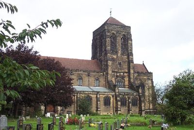
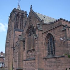
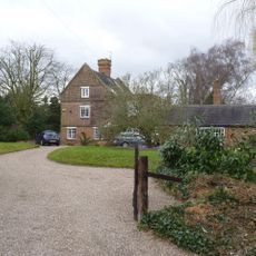
St Mary's, Stretton, church in Stretton, Staffordshire, UK

St Mary's in Stretton is a church with a cruciform floor plan and a large central tower, built primarily of yellow sandstone on the exterior and red sandstone within. The building contains a nave with side aisles, a chancel, and several chapels, with interiors adorned with carved woodwork, stone figures, and stained glass windows.

The church was consecrated in 1897 and replaced a smaller chapel built in 1837 to serve the growing community. The new building was financed by John Gretton, a local businessman, and designed by two prominent Victorian architects.

The church bears the name St Mary's in honor of the Virgin Mary, a significance reflected throughout its interior decoration and layout. The Lady Chapel in the south aisle remains a space where visitors can sit and reflect, with windows depicting scenes of the Ascension and Pentecost.

Access to the church is through two west-facing entrances, one of which features a stone statue of St Chad above the door. The interior is bright and airy, with good lighting for reading and attending services, plus modern amenities such as a sound system and projector.

A hidden detail is the chronogram inscribed in the sanctuary, which marks the consecration year in Latin numerals cleverly embedded in text. This subtle medieval technique allows visitors to discover the year 1897 concealed in sacred language.

The community of curious travelers

AroundUs brings together thousands of curated places, local tips, and hidden gems, enriched daily by 60,000 contributors worldwide.

Start exploring
Location
GPS coordinates
52.83410,-1.62480
Latest update
February 9, 2026 11:07
Around this place
Monks Bridge
United Kingdom

Monks Bridge

1.6 km
Claymills Pumping Station
United Kingdom

Claymills Pumping Station

1 km
Bladon Castle
United Kingdom

Bladon Castle

2.1 km
Dovecliff Hall
United Kingdom

Dovecliff Hall

1.2 km
St John the Divine
United Kingdom

St John the Divine

1.7 km
St. Chad's Church
United Kingdom

St. Chad's Church

2 km
St Wilfrid's Church, Egginton
United Kingdom

St Wilfrid's Church, Egginton

2 km
1, Chapel Lane
United Kingdom

1, Chapel Lane

1.9 km
Dove Aqueduct
United Kingdom

Dove Aqueduct

1.6 km
Milepost At Beam Hill Cross Roads (Ngr Sk2346125998)
United Kingdom

Milepost At Beam Hill Cross Roads (Ngr Sk2346125998)

1.9 km
Craythorne Hall (Now Includes Craythorne Grange)
United Kingdom

Craythorne Hall (Now Includes Craythorne Grange)

972 m
The Spread Eagle Public House
United Kingdom

The Spread Eagle Public House

2.2 km
Brookhouse Inn
United Kingdom

Brookhouse Inn

2.1 km
Former Hydraulic Power House
United Kingdom

Former Hydraulic Power House

2.2 km
Perimeter Wall To East, North And South Of The Almshouses, Nos. 2, 4, 6, 8 And 12
United Kingdom

Perimeter Wall To East, North And South Of The Almshouses, Nos. 2, 4, 6, 8 And 12

2.2 km
14 And 16, Burnside
United Kingdom

14 And 16, Burnside

2.2 km
Trent And Mersey Canal Milepost At Sk 259 260
United Kingdom

Trent And Mersey Canal Milepost At Sk 259 260

655 m
3, Beacon Road
United Kingdom

3, Beacon Road

1.9 km
1, Beacon Road
United Kingdom

1, Beacon Road

1.9 km
5 And 6, Bladons Yard
United Kingdom

5 And 6, Bladons Yard

2.1 km
Barn Farmhouse
United Kingdom

Barn Farmhouse

2.1 km
Milepost At Royal Oak Inn (Ngr Sk2433524765)
United Kingdom

Milepost At Royal Oak Inn (Ngr Sk2433524765)

1.9 km
Milepost, Tutbury Road, jct with BeamHill Road at Outwoods Cross
United Kingdom

Milepost, Tutbury Road, jct with BeamHill Road at Outwoods Cross

2 km
Hand Pump Approximately 10M East Of The Almshouses
United Kingdom

Hand Pump Approximately 10M East Of The Almshouses

2.2 km
The Almshouses
United Kingdom

The Almshouses

2.2 km
The Croft House
United Kingdom

The Croft House

2.2 km
Milepost, Horninglow Road North; by Royal Oak PH, just W of bypass flover
United Kingdom

Milepost, Horninglow Road North; by Royal Oak PH, just W of bypass flover

1.9 km
Milestone, Horninglow Road North; by Royal Oak PH, just west of bypass flover
United Kingdom

Milestone, Horninglow Road North; by Royal Oak PH, just west of bypass flover

1.9 km
Show the full map
« St Mary's, Stretton - church in Stretton, Staffordshire, UK » is provided by Around Us (aroundus.com). Images and texts are derived from Wikimedia project under a Creative Commons license. You are allowed to copy, distribute, and modify copies of this page, under the conditions set by the license, as long as this note is clearly visible.

Discover hidden gems everywhere you go!

From secret cafés to breathtaking viewpoints, skip the crowded tourist spots and find places that match your style. Our app makes it easy with voice search, smart filtering, route optimization, and insider tips from travelers worldwide. Download now for the complete mobile experience.

Around Us App Screenshot

A unique approach to discovering new places

Le Figaro

All the places worth exploring

France Info

A tailor-made excursion in just a few clicks

20 Minutes

Around Us
Travel Guide & Maps
Download

Send to your phone

QR Code
1

Open the camera app on your mobile.

2

Point at the QR code with your camera. A notification will appear.

3

Tap the notification to open the link.