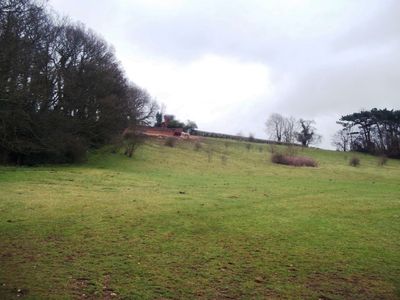
Bladon Castle, Gothic folly in Newton Solney, England
Bladon Castle is a Gothic folly in Newton Solney, Derbyshire, built in the early 1800s. It features battlements, a corner turret, and connected parapet walls in the Neo-Gothic style, though it is actually constructed as one extended wall designed to create the illusion of a larger fortified building.
Architect Jeffrey Wyattville designed this building in the early 1800s for landowner Abraham Hoskins of Burton-on-Trent. It later evolved from a purely decorative structure into a residence, with rooms added while keeping its original castle-like appearance.
The structure reflects a 19th-century English fashion where landowners created decorative buildings to add drama and interest to their grounds. It represents how the wealthy used architecture to shape their landscapes and express romantic ideals about castles and history.
The building can be viewed from designated viewpoints along Newton Road while maintaining distance from the private property. It is visible from the public footpath, but respect the boundaries of the private grounds and do not attempt to enter the property.
The building plays with perception and scale, as the front facade makes it appear far larger than its actual depth. This optical trick was intentional from the start and remains a surprising discovery for visitors who walk around the property to examine it from different angles.
Location: Newton Solney
GPS coordinates: 52.82260,-1.60093
Latest update: December 14, 2025 12:26
National Brewery Centre
2.7 km
Monks Bridge
1.9 km
Claymills Pumping Station
1.1 km
Winshill Water Tower
2.4 km
Dovecliff Hall
2.6 km
St John the Divine
2.8 km
Burton Mill
1.2 km
St Mark's, Winshill
1.6 km
St. Chad's Church
2.4 km
St Mary's, Stretton
2.1 km
St Wilfrid's Church, Egginton
2.8 km
Church of St Mary the Virgin, Newton Solney
1.2 km
167, Horninglow Street
2.6 km
Stone Archways At Gateway To Cemetery
2.6 km
Dove Aqueduct
1.9 km
Milepost, Ashby Road; Winshill, by No. 29, below junction with Mervyn Road
2.1 km
Water Tower About 100 Metres To Rear Of Offices Of Bass's Brewery
2.8 km
Former Hydraulic Power House
2.3 km
Trent And Mersey Canal Milepost At Sk 259 260
1.4 km
Newton Solney pipe bridge
2.1 km
Milepost At Royal Oak Inn (Ngr Sk2433524765)
2.7 km
Magistrates Court
2.6 km
Cattle Bridge
2.8 km
Burton Bridge
2.3 km
Pickford's Bonded Warehouse
2.4 km
Milestone, Ashby Road East; outside No. 25, adj County Boundary
2.8 km
Milepost, Horninglow Road North; by Royal Oak PH, just W of bypass flover
2.7 km
Milestone, Horninglow Road North; by Royal Oak PH, just west of bypass flover
2.7 kmVisited this place? Tap the stars to rate it and share your experience / photos with the community! Try now! You can cancel it anytime.
Discover hidden gems everywhere you go!
From secret cafés to breathtaking viewpoints, skip the crowded tourist spots and find places that match your style. Our app makes it easy with voice search, smart filtering, route optimization, and insider tips from travelers worldwide. Download now for the complete mobile experience.
A unique approach to discovering new places❞
— Le Figaro
All the places worth exploring❞
— France Info
A tailor-made excursion in just a few clicks❞
— 20 Minutes