St Mary's Church, Chastleton

Log in to your account

AroundUs is a community-driven map of interesting places, built by curious explorers like you. It grows with every review, story, and photo you share.
Connect to save your favorite spots, contribute locations, and create personalized routes.
Continue with Google
Continue with Apple
Continue with X
Continue with Facebook
Continue with email
By continuing, you accept our Terms and Conditions and our Privacy Policy
Create an account

St Mary's Church, Chastleton

Add to collection
Map
Suggest a change
Share

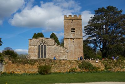
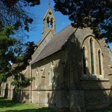
St Mary's Church, Chastleton, Norman church in Chastleton, England.

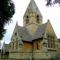
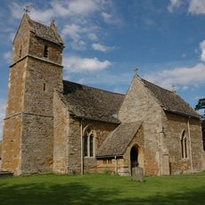
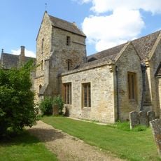
St Mary's Church is a Norman building in Chastleton, constructed around 1100 and featuring rounded arches and thick pillars that show medieval building methods. The interior contains a Jacobean pulpit from 1623 and Victorian-era seating, with a bell tower added in 1689 that holds six bells.

The church was built around 1100 and expanded in 1320, with its original Norman structure largely preserved through the centuries. The bell tower was added in 1689, marking a later period of architectural development for the building.

Religious paintings cover the north wall, dating from the 17th and 18th centuries and uncovered during restoration in the 1930s. These artworks show how the church was decorated during different periods of worship and artistic practice.

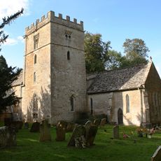
The church welcomes visitors during service times and is normally open for viewing the interior and its furnishings. The surrounding churchyard provides a peaceful space to walk around and see the building from different angles.

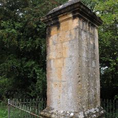
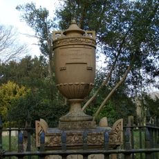
The bell tower contains six bells, with the oldest cast in 1696, offering a rare example of how the sound of worship has carried through centuries. The churchyard also holds the tomb of sculptor Sir Richard Westmacott, a major Victorian-era artist whose works appear across Britain.

Location: Chastleton

Inception: 14 century

Architectural style: Norman architecture

Website: http://stmaryscnorton.com/around-the-benefice.php

GPS coordinates: 51.95955,-1.63958

Latest update: December 14, 2025 11:03

Photos
Around this place
Daylesford House
United Kingdom

Daylesford House

2.7 km
Chastleton House
United Kingdom

Chastleton House

39 m
Four shire stone
United Kingdom

Four shire stone

3.6 km
Church of St Peter
United Kingdom

Church of St Peter

3.2 km
Church of St Mary
United Kingdom

Church of St Mary

3.9 km
Church of St Mary Magdalene
United Kingdom

Church of St Mary Magdalene

2.2 km
Church of St Philip
United Kingdom

Church of St Philip

4.6 km
Church of St Edward
United Kingdom

Church of St Edward

2.8 km
Church of St Lawrence
United Kingdom

Church of St Lawrence

3.5 km
Church of St Nicholas
United Kingdom

Church of St Nicholas

3.8 km
Cornwell Manor
United Kingdom

Cornwell Manor

3 km
Church of St Peter
United Kingdom

Church of St Peter

3.2 km
Church of St Denis
United Kingdom

Church of St Denis

1.8 km
Church of the Holy Ascension
United Kingdom

Church of the Holy Ascension

3.7 km
Adlestrop Park
United Kingdom

Adlestrop Park

2.3 km
Dovecote Approximately 130 Metres South East Of Chastleton House
United Kingdom

Dovecote Approximately 130 Metres South East Of Chastleton House

104 m
Monument With Railings To Warren Hastings In The Churchyard Of The Church Of St Peter Circa 1 Metre East Of East End Of Chancel
United Kingdom

Monument With Railings To Warren Hastings In The Churchyard Of The Church Of St Peter Circa 1 Metre East Of East End Of Chancel

3.2 km
Milestone At Ngr Sp 2327 3199
United Kingdom

Milestone At Ngr Sp 2327 3199

3.3 km
Adlestrop House
United Kingdom

Adlestrop House

2.2 km
Stables And Brew House Approximately 12 Metres South West Of Castleton House
United Kingdom

Stables And Brew House Approximately 12 Metres South West Of Castleton House

62 m
Gateway, Attached Garden Walls And Coach House To South Of Main Front Of Chastleton House
United Kingdom

Gateway, Attached Garden Walls And Coach House To South Of Main Front Of Chastleton House

40 m
Barton House
United Kingdom

Barton House

3.6 km
The Old School House
United Kingdom

The Old School House

3.2 km
RAF Moreton-in-Marsh Memorial
United Kingdom

RAF Moreton-in-Marsh Memorial

4.1 km
Milestone, 200m SE of The Cross Hands PH & Chastleton Quarry (jct A436); close to lane for Hollis Hill Farm
United Kingdom

Milestone, 200m SE of The Cross Hands PH & Chastleton Quarry (jct A436); close to lane for Hollis Hill Farm

2.4 km
Milestone, London Road; 50m E of Cotswolds Business Village
United Kingdom

Milestone, London Road; 50m E of Cotswolds Business Village

4.5 km
Milestone, by jct of UC road to Upper Oddington village, opp entrance to Hill farm
United Kingdom

Milestone, by jct of UC road to Upper Oddington village, opp entrance to Hill farm

4.2 km
Milestone, Kitebrook House
United Kingdom

Milestone, Kitebrook House

2.1 km
Show the full map
Reviews

Visited this place? Tap the stars to rate it and share your experience / photos with the community! Try now! You can cancel it anytime.

« St Mary's Church, Chastleton - Norman church in Chastleton, England » is provided by Around Us (aroundus.com). Images and texts are derived from Wikimedia project under a Creative Commons license. You are allowed to copy, distribute, and modify copies of this page, under the conditions set by the license, as long as this note is clearly visible.

Discover hidden gems everywhere you go!

From secret cafés to breathtaking viewpoints, skip the crowded tourist spots and find places that match your style. Our app makes it easy with voice search, smart filtering, route optimization, and insider tips from travelers worldwide. Download now for the complete mobile experience.

Around Us App Screenshot

A unique approach to discovering new places

Le Figaro

All the places worth exploring

France Info

A tailor-made excursion in just a few clicks

20 Minutes